also see Climate Change Page
.jpg)
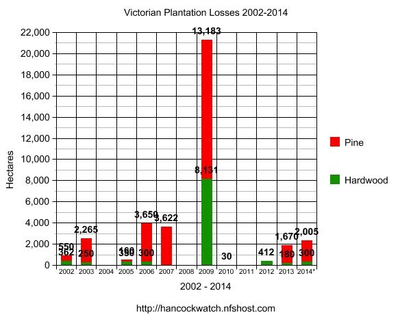
35,470 ha of hardwood and softwood plantations (including 685ha of MIS land/Research plots) have burnt in Victoria since 2002 (~2950ha/yr). This represents ~7.8% of the state's 2012 plantation base (0.65% yr of State Plantation Base - based on last 12 years).
Almost 25,000 ha of pine plantations have burnt in Victoria since 2002 (2070 ha/yr). This represents ~11.3% of the state's 2012 plantation base. 0.94%/yr of State Plantation Base per year - based on last 12 years. [In the preceeding 70 years possibly 10,000ha of plantations would have suffered from fire, meaning that ~80% of the area burnt in the states plantations have occurred during the past decade].
Between 1973-98 it had been reported that state plantation base losses (in state owned plantations) were 0.15% per year. Hancock Victorian Plantations purchased the state plantations in 1998. Since 2002, approximately 13,400ha of these plantations have been burnt. This represents ~12.5% of the ex State Pine assets or 1.04% of the ex state plantation base per year. This represents a 690% increase on losses estimated between 1973-1998.
Limited figures have been found on the amount of private pine plantation losses between 1973-98, but it is assumed that losses were minimal. Fire losses recorded by Australian Paper in their plantations for example between 1961-95 were 771ha or 30.84ha/yr or 0.078%/yr (based on 1994 Australian Paper plantation figures). Private plantation losses - excluding ex State Pine Plantations - between the years 2002-2012 have been approximately 12,000ha (1000ha/yr) (a large portion of which is Hancock purchased plantations from Australian Paper Plantations in 2001). This represents 10.4%, or 0.87%/yr of privately owned softwood plantations, an increase of 1100% on plantation base losses estimated by Australian Paper between 1961-95.
~9,950ha (~830 ha/yr) of Victoria's hardwood plantations have burnt since 2002. This represents 4.3% of the state's 2012 hardwood plantation base, or 0.36%/yr. Approximately 80% of hardwood plantations burnt were Hancock plantations burnt over January/February 2009, in the Delburn and Churchill fires.
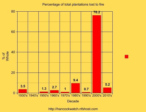
Clearly, then plantations, particularly pine plantations, are a much more risky proposition than in any other time over the past 40 years. Plantation losses are amplified by bushfire risk. Many plantation fires are caused by outside influences. Risks are likely to increase significantly due to climate change and the increase of severe bushfire days.
*refers to 2014 up to February 10.
graph does not include 2014 totals
| Approximate Date | Area | Size | ||
| 1. | February 7/8 2009 | Strzelecki Ranges | 10706ha | Pine and Hardwood |
| 2. | February 7/8 2009 | Central Highlands | 4044ha |
Pine |
| 3. | December 2006/January 2007 | Mansfield Region + North East Region | 3622ha | Pine |
| 4. | January 28/30 2009 | Delburn (Boolara) Fires (Gippsland) | 2700ha (1) | Pine and Hardwood |
| 5. | February 2003 | Beechworth Region | 1927ha | Pine |
| 6. | February 7/8 2009 | North East Victoria | 1850ha | Pine |
| 7 | February 9 2014 | Strzelecki Ranges - Jack River | 1600ha | Pine |
| 8. | February 7 2009 | Wandong - Central Region | 1549ha (2) | Pine and Hardwood |
| 9. | February 16 1983 | Macedon | 1326ha (3) | Pine |
|
10.
|
March 12 2006
|
Linton/Scarsdale
|
1200ha
|
Pine
|
| 11. | January 13 2013 | Kentbruck (South West Victoria) | 1200ha | Pine |
| 12. | January 1985 | Morses Creek (North East Victoria) | 1100ha | Pine |
| 13. | January 13 1939 | Bright (North East Victoria) | 1000ha (4) | Pine |
| 14. | December 2006 | Yinnar (Gippsland) grassfire & 900ha pine | 900ha (5) | Pine |
| 15. | December 2006 | Coopers Creek Fire (Gippsland) | 850ha (6) | Pine |
| 16. | January 31 2006 | Moondarra Fire (Gippsland) | 850ha | Pine and Hardwood |
| 17. | February 16/17 1983 | Boonah (Otway Ranges) | 789ha (7) | Pine |
| 18. | February 2002 | McGauran's Fire (Gippsland) | 662ha | Pine and Hardwood |
| 19. | 1955 | The Pines Forest (Frankston) | 567ha (8) | Pine |
| 20. | January 13 1939 | Narbethong | 553ha (9) | Pine |
| 21. | April 2005 | Dunmore (South West Victoria) | 350ha | Hardwood |
(1) At this stage it is unclear whether industry has recorded the amount of plantations lost in the Delburn Fires into the total amounts of plantation lost in Gippsland in the February 7/8 2009 fires (10,706)ha. At this time it is assumed that plantation losses recorded one week earlier at Delburn have been recorded as being seperate and therefore additional to the plantations lost in plantations one week later.
(2) Amount of plantation owned primarily by Midways lost estimated. Also unknown at this stage exact percentage of pine/hardwood, as some areas of plantation had been converted from pine to hardwood in the preceeding few years.
(3) The amount of plantations lost in the Macedon fires has been estimated.
(4) Historical reports state that 4000ha of plantations were burnt in the 1939 fires. Only 1200ha of plantations had been established by the state government up to 1939. As such, the 4000ha figure is likely to be wrong. 1000ha burnt has been estimated as it may have included some privately grown plantations.
(5) Reported in the media - exact amount burnt may have been inaccurate.
(6) Limited media reports about exact areas burnt could be located. This is an estimate based on plantation map analysis.
(7) Two totals have been found in the historical records regarding the amount of plantations burnt in these fires. The estimate used in this report are the lower estimates as provided by the State Government.
(8) Exact size of fire not sourced and is based on size of plantation, most of which was apparently incinerated.
(9) The amount of plantations lost at Narbethong appears to be accurate. However if this is correct then the amount of plantation lost elsewhere in the 1939 fires (see (3)) may be overstated.
.jpg)
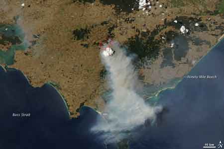
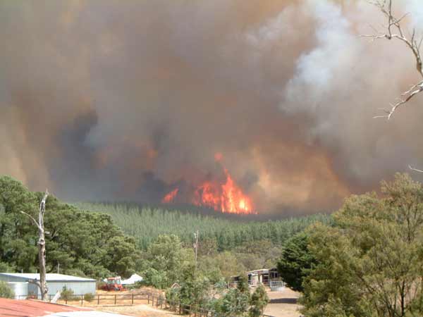
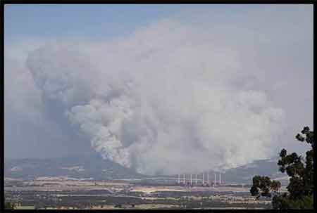
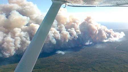
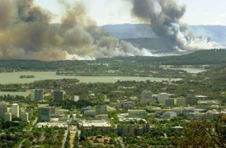
Jan 31 2009: ~50% of the smoke plume in this image is coming from Hancock plantations burning in Gippsland. Are plantations really greenhouse friendly? Are Hancock plantations contributing to global warming?
5.6. Victoria Data collected over the 31 years from 1973 to 2003 indicates that the Department of Sustainability and Environment (DSE), and its equivalent agencies in earlier years, attended an average of 516 fires each year on land it manages, with each fire burning an average area of 203 ha. Of the 516 fires each year, on average 12 commenced in State-owned softwood plantation, or plantation that was originally owned by the State. The fires that did not originate in softwood plantation burnt an average area of 207 ha, while the fires that did originate in plantation burnt an average area of 51 ha. For the 27 year period from 1973 to 1999, Tolhurst (2001) indicates the loss of Stateowned softwood plantation averaged 0.15% pa of the total softwood plantation area.
Victorian data from the last 31 years indicate that fires that have originated in softwood plantations have burnt less total area, on average, than fires that burnt softwood plantation where the origin was outside the plantation boundary. Good access to softwood plantations and effective first attack arrangements are probably the reasons for this result. Source: Softwood Plantation Fire Synopsis Compiled by Forest Fire Management Group (FFMG) is a sub-Committee of the Forestry and Forest Products Committee which reports to the Primary Industry Ministerial Council Endorsed by: Australasian Fire Authorities Council Ltd (AFAC) ISBN 0 643 06533 4 © Forest Fire Management Group November 2007. http://www.royalcommission.vic.gov.au/Documents/Document-files/Exhibits/WIT-3004-032-0323
"...Between 1974 and 1994 Victoria recorded 308 fires which burnt about 5% (5,540ha), of its 106,000ha of state owned pine plantations, giving an average fire size of 18ha (CFA/DCNR/VPC, 1994)" Source: Fire Management in Pine Plantations. Prepared by Tony Bartlett, Director, ACT Forests.
.jpg)
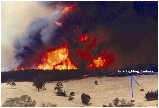
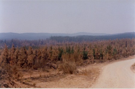
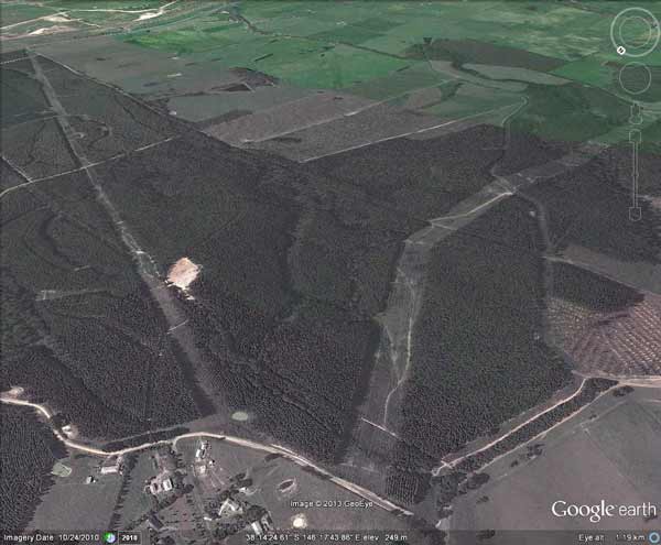
February 2003: Midways Plantations Wandong. It is unknown how many hectares were burnt in this fire.
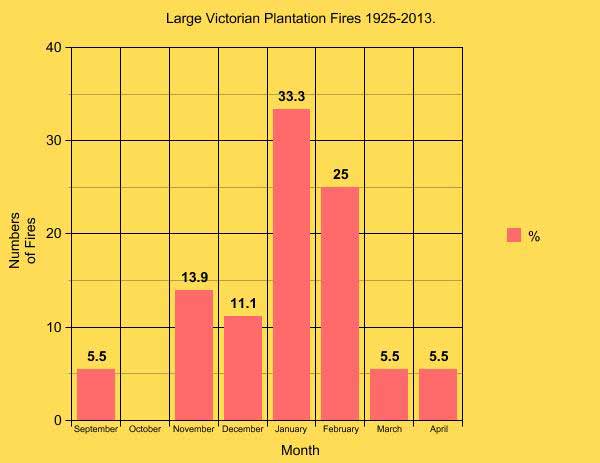
January is the most prevalent time of the year for large fire events in Victorian plantations.
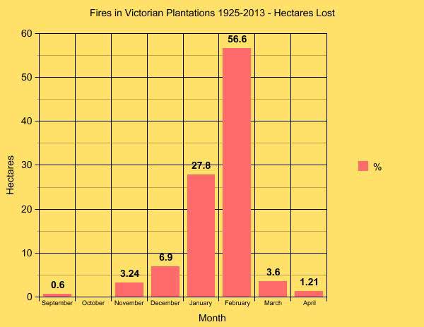
However, the most damaging fires, in terms of hectares burnt occur in February, with the February 2009 fires being the most destructive..
16 January 1928: Creswick http://trove.nla.gov.au/ndp/del/article/45998670
12 feb 1934 Heywood 283ha (700 acres). Doubt on exact number burnt. Must have been privately grown.
27 September 1938: Mt Macedon. Unknown acres. http://trove.nla.gov.au/ndp/del/article/91452563
(This figure is likely to be wrong as the state public plantation base in 1939 was only 1200ha)
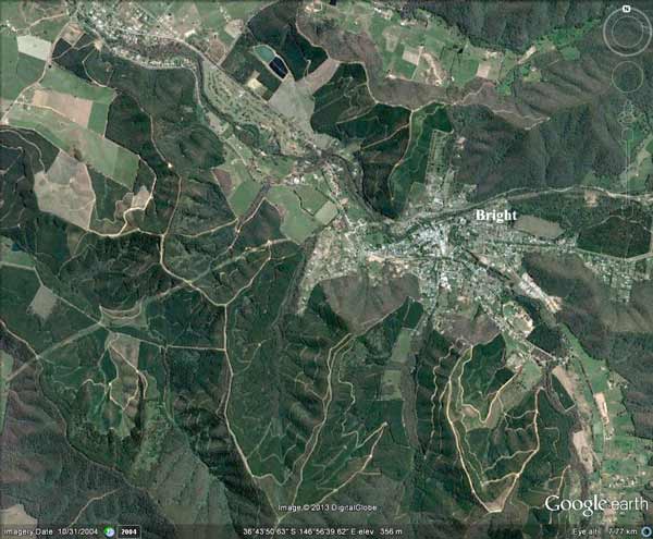
The township of Bright, in the states North East is surrounded by plantations. Major fires 1939, 1982 & 1985.
553 ha burnt at Narbethong. http://www.forestscience.unimelb.edu.au/people/staff/sabine_kasel/publications/Former_pine_restoration_Australia.pdf
13 January 1939 4,000? hectares of plantations. Source: http://home.iprimus.com.au/foo7/firesum.html
Frankston Pines: http://en.wikipedia.org/wiki/Frankston_North,_Victoria
17 November 1962 Longford (Gippsland): 111ha radiata pine (Source: Softwood Plantation Fire Synopsis Forest Fire Management Group November 2007.
1961-5: 472ha* (Gippsland)
AP Gippsland pine losses: 472ha/94.4ha/yr
Plantation Risk Factors http://www.mbac.com.au/upload/mbac/2004-03-gippsland-pf/team/gpf-panel/98132%20Final%20Report%20modified%20MBAC.pdf
3 March 1965: Blanket Hill 324ha (Gippsland private?) (Source: Softwood Plantation Fire Synopsis Forest Fire Management Group November 2007.
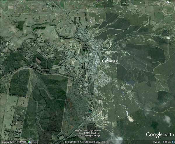
Township of Creswick - Plantations concentrated on south west, east and north east sections of the town. Major fires occurred in these plantations in 1928, 1966 and 1977.
25 January 1966: Creswick 200ha (Source: Softwood Plantation Fire Synopsis Forest Fire Management Group November 2007.
1966-70: 62ha* (Gippsland)
AP Gippsland pine losses: 62ha/12.4ha/yr
Plantation Risk Factors http://www.mbac.com.au/upload/mbac/2004-03-gippsland-pf/team/gpf-panel/98132%20Final%20Report%20modified%20MBAC.pdf
1971-5: 26ha* (Gippsland)
AP Gippsland pine losses: 26ha/5.2ha/yr
Plantation Risk Factors http://www.mbac.com.au/upload/mbac/2004-03-gippsland-pf/team/gpf-panel/98132%20Final%20Report%20modified%20MBAC.pdf
1976-80: 34ha* (Gippsland)
AP Gippsland pine losses: 13ha/2.6ha/yr
Public Plantations 21ha?
Plantation Risk Factors http://www.mbac.com.au/upload/mbac/2004-03-gippsland-pf/team/gpf-panel/98132%20Final%20Report%20modified%20MBAC.pdf
2 February 1979 (South West Victoria): LEGL93-15 Caroline/Rennick Fire 3334ha softwood mostly in SA 163ha Vic http://www.dse.vic.gov.au/__data/assets/pdf_file/0006/101220/7_Research_Report.pdf
1981-85: 168.5ha (Gippsland)
AP Gippsland pine losses: 162ha/32.4ha/yr
Public Plantations: 6.5ha
Plantation Risk Factors http://www.mbac.com.au/upload/mbac/2004-03-gippsland-pf/team/gpf-panel/98132%20Final%20Report%20modified%20MBAC.pdf
November 1982 (North East Victoria): Bright plantation fire. LEGL93-128, LEGL93-129, LEGL93-130 Started in Two Mile Creek Plantation. 332ha http://www.dse.vic.gov.au/__data/assets/pdf_file/0009/101232/19_Research_Report.pdf
(2300ha http://www.dse.vic.gov.au/__data/assets/pdf_file/0020/141815/Impacts-Losses-of-Fire-Report-88.pdf)
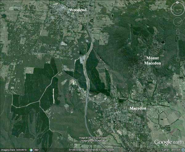
Macedon Plantations, mostly leased by Hancock. Major fires in 1938, 1983 & 1998.
1 February 1983: 150 hectares of mature plantations at Macedon (park) http://www.foresthistory.org.au/afhsnewsletter05.pdf
16 February 1983: Macedon Fires took out all of LEGL93-57, LEGL93-58 (1326ha?) http://bushfirehistory.wikispaces.com/Macedon+Ranges
The Ash Wednesday (http://nrfa.fire.org.nz/research/_docs/Fttn3-pinepaper.PDF) fires of 16 February 1983 in southeastern Australia caused considerable loss of life and property damage,including 16,070 ha of pine plantation being burned over in the southeast region of South Australia (Keeves andDouglas 1983); table 2 values are for 1 p.m. at Penola, SA.
16/17 November 1983 (Otways): 789ha (or 973?ha*) burnt near Boonah only Paddy's Swamp plantation was not burnt. LEGL93-44 burnt out, LEGL93-45 burnt out except Paddys Swamp. 624ha burnt at Retreat Plantation, 90ha South Wormbete, 85ha North Wormbete http://www.dse.vic.gov.au/__data/assets/pdf_file/0011/101234/Research_Report_21.pdf
* (Source: Softwood Plantation Fire Synopsis Forest Fire Management Group November 2007.
Boonah (Retreat) Plantation completely burnt out in November 1983
January 1985 State plantations - 1100 ha P. radiata Morses Creek LEGL 93-130, LEGL93-131, LEGL 93-132 - 200 ha P. radiata Rose Valley LEGL93-156 - cost $1.2 million Private plantations - 40 ha P. radiata Rose River - 25 ha P. radiata Buckland River All the commercial sized P. radiata killed in the fires will be salvaged. http://www.dse.vic.gov.au/__data/assets/pdf_file/0016/100906/1985_season_summary.pdf
1986-90: 58.5ha (Gippsland)
AP Gippsland pine losses: 26ha
Public Plantations: 32.5ha
Plantation Risk Factors http://www.mbac.com.au/upload/mbac/2004-03-gippsland-pf/team/gpf-panel/98132%20Final%20Report%20modified%20MBAC.pdf
1991-95: 112.5ha (Gippsland)
AP Gippsland pine losses: 111ha
Public Plantations: 1.5ha
Plantation Risk Factors http://www.mbac.com.au/upload/mbac/2004-03-gippsland-pf/team/gpf-panel/98132%20Final%20Report%20modified%20MBAC.pdf
1996-98: 87.5ha (Gippsland)
AP Gippsland pine losses: 26ha
Public Plantations: 61.5ha
Plantation Risk Factors http://www.mbac.com.au/upload/mbac/2004-03-gippsland-pf/team/gpf-panel/98132%20Final%20Report%20modified%20MBAC.pdf
1998: Macedon Ranges: Pine Forest. In 1998 there was a large fire in the pine forest to the north of Macedon township. It was the first threatening fire after Ash Wednesday and so brought back alot of memories and anxieties for those who had lived through Ash Wednesday. It threatened houses to the north of the town. However as luck would have it there was a convention of fire fighting aircraft and other equipment at Essendon airport, approxamatley 50km away. So many resources, including Elvis, were used to keep the fire at bay and save houses.http://bushfirehistory.wikispaces.com/Macedon+Ranges 1998 hundreds of acres of pines at macedon http://www.gisbornecfa.com/history/
February 2002: McGauran's Fire 662ha Eucalypt & Pine Traralgon Gippsland http://www.parliament.vic.gov.au/images/stories/committees/enrc/055_Grand_Ridge_Plantations.pdf
September 16 2002: 250ha Mount Lonarch hancock? http://www.theage.com.au/articles/2002/09/16/1032054747659.html
Feb 2003: Beechworth Plantations take a big hit in January 2003.
January 2003: (Longford Emu Track) Hancock 238ha. http://www.parliament.vic.gov.au/images/stories/committees/enrc/055_Grand_Ridge_Plantations.pdf
January 2003 (Toms Cap) Hancock 100ha http://www.parliament.vic.gov.au/images/stories/committees/enrc/055_Grand_Ridge_Plantations.pdf
February 2003 (North East Victoria): 1927ha hancock pine beechworth LEGL93-137-1. http://www.dse.vic.gov.au/__data/assets/pdf_file/0020/141815/Impacts-Losses-of-Fire-Report-88.pdf
February 2003 (Gippsland): 250 ha Hancock bluegums Gippsland http://www.planningplantations.com.au/assets/pdfs/sustainability/environment/fire/AFGAutumn06_GeddesArticle.pdf
April 9 2005 (South West Victoria) : 350ha Bluegums western Victoria Dunmore fire Timbercorp http://www.planningplantations.com.au/assets/pdfs/sustainability/environment/fire/FireBehaviourHarwoodPlantations.pdf
April 10 2005 (Central Victoria): 160ha pine 4km east of Linton LEGL92-29.
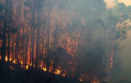
Moondarra Fire: Courtesy Image CFA
January 25 2006 (Western Victoria): 150ha Grampians fires timbercorp bluegum
January 31 2006: Moondarra Fires LEGL93-120. http://hancockwatch.nfshost.com/docs/06jan.htm#Fire Hancock lost 400ha (250ha pine, 150ha hardwood), Gippsland Water (450ha pine)
http://www.parliament.vic.gov.au/images/stories/committees/enrc/055_Grand_Ridge_Plantations.pdf
March 12 2006 (Central Victoria): Linton Fires. 1200ha pine at Scarsdale. LEGL93-29
December 2006: (Gippsland) Coopers Creek Fire. 850ha?
December 2006: (Strzeleckis) Yinnar Grass fire apparently also burnt out 900ha? of pine.
December 06/January 2007: 1600ha south and north of Mansfield (North East Victoria). Hancock LEGL93-65, LEGL93-66 LEGL94-16, LEGL93-154/1 http://www.parliament.vic.gov.au/images/stories/committees/enrc/bushfire_inquiry/Submissions/243_Plantations_North_East.pdf
January 2007: 2022ha pine (additional to Hancock pine) - mostly privately owned. Source: The impacts, losses and benefits sustained from five severe bushfires in south-eastern Australia Fire and adaptive management report no. 88
Churchill Fires February 2009. 25% of Hancock's hardwoods go up in one afternoon!
January 30 2009 (South Western Victoria). 175ha bluegums near Branxholme http://timbercorp.ezywiz.biz/default.asp?cid=15203&menuid=13240
Jan 28-30 2009: Delburn fires: 1000ha pine, 1700ha hardwood http://hancockwatch.nfshost.com/docs/09feb.htm
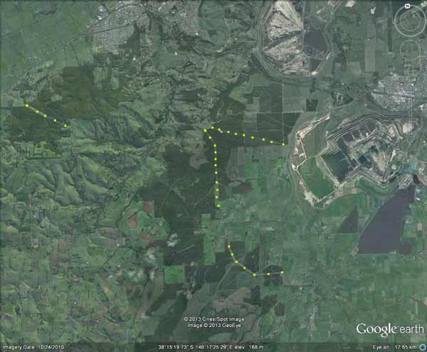
February 7 2009. Hancock hit by massive bushfires in Strzeleckis, Central Region and North East Victoria. ~17,000ha plantations burnt. (Total Amount Lost: 16,559ha of productive plantation. 4044ha of pine in Central Highlands, 1850ha of pine in North East Victoria, 4650ha of pine in Strzeleckis/Gippsland, 6025ha of hardwood in Strzeleckis Gippsland, 330ha research plots, 355ha MIS land. Source: VAFI Submission into Bushfires Enquiry). Hancock losses North East: LEGL 125, LEGL93-139, LEGL93-141, LEGL 93-144. Central Region: LEGL93-67, LEGL93-69, LEGL93-70, LEGL93-71. Strzelecki Region: LEGL93-105, LEGL93-106, LEGL93-107, LEGL93-123 plus thousands of hectares of ex Australian Paper Plantations land.
February 7 2009 : 1549ha Midways pine + 200ha bluegum (Wandong/Redesdale)
February 7 2009: 31.2hectares bluegum (Churchill fire)
December 24 2009: 90 ha Nareeb (SW Victoria) http://www.abc.net.au/news/stories/2009/12/24/2780335.htm?site=westernvic
November 10 2010. 30ha hvp pine Longford http://www.abc.net.au/news/stories/2010/11/10/3062169.htm?site=gippsland
March 13 2012: Branxholme 50ha bluegum? http://www.spec.com.au/blog/2012/03/13/branxholme-fire/
November 22 2012: 100ha bluegums western vic Casterton http://au.news.yahoo.com/thewest/a/-/national/15443300/winds-fan-flames-in-victorias-west/
December 10 2012: 250ha bluegum near Seymour http://www.weeklytimesnow.com.au/article/2012/12/10/552692_print_friendly_article.html
December 19 2012: 12ha Beaufort bluegums http://www.thecourier.com.au/story/1195199/scrub-fire-burns-bluegum-plantation-near-beaufort/
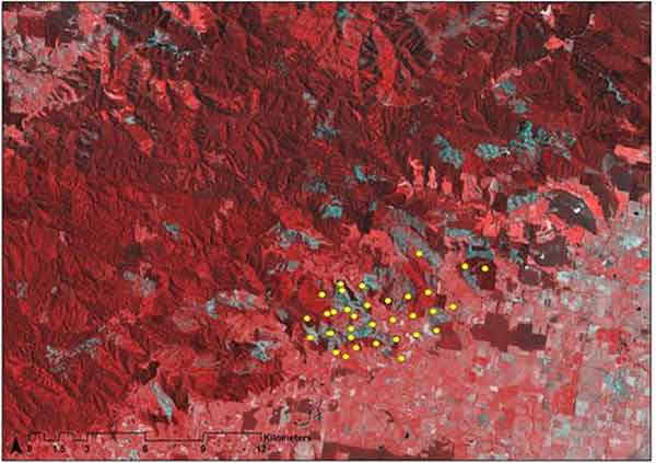
Jan 2013: Kentbruck Fires Photo looking south: Stewart Beaton/DSE
January 2013 (South West Victoria): http://news.smh.com.au/breaking-news-national/backburning-around-vic-plantation-fire-20130110-2cims.html It has destroyed 1200 hectares of pine plantations worth about $7.5 million. That makes it the largest single loss of plantation assets in the Green Triangle area since the 1983 Ash Wednesday fires, the incident management team's plantation technical adviser Andrew Moore said. 1000ha Kentbruck LEGL93-12, 200ha GTFP.
January 18 2013: Gippsland. Aberfeldy Donnellys Fire. 50ha hardwood (Midways) Seaton.
January 21 2013: Creswick 20ha (estimate) LEGL93-40
February 2013: Buangor/Middle Creek Fires - grassland and plantation fires.
February 18 2013: Grampians - Victoria Valley Complex 80ha Bluegums? Billywing Pines 400ha?
February 18 2013: Castlemaine Plantation a High Fire Risk Says Research
February 20 2013: Embers in Billywing
March 27 2013: Mirboo North/Hallston Fire 50ha Hancock pine, 50ha Midways Bluegum
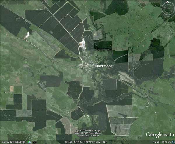
Dartmoor in Victoria's south west is surrounded by plantations. January 2013 fires came within 10km of the town.
The second class-action lawsuit, filed last week, includes more than two dozen Gippsland bushfire victims hoping to recover up to $5 million in lost or damaged property. A fire near Yarram ignited a tree plantation on the same day. The lawsuit alleges the blaze, which burnt 5000 hectares, was sparked when trees came into contact with a distribution line on Egans Road. At least one home was destroyed.
Jan 13 2014: Trawalla bluegum plantations - 300ha grasslands/bluegums fire . 50ha bluegums?
Feb 13: Iguana Creek? 100ha Pine?
Feb 13: Driffield/Haunted Hills 250ha hardwood/pine
Feb 13: Maryvale: 300ha pine?
Feb 13: Jack River 1600ha pine?
Feb 13: Castlemaine/Barkers Creek 5ha
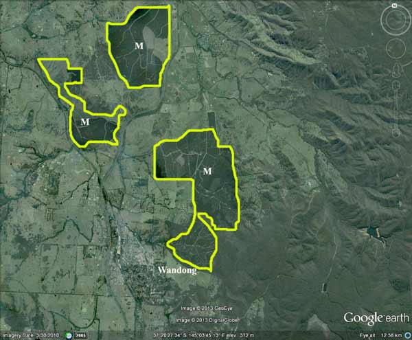
The Kilmore East fire was a grass fire which after entering the Midways plantation was unstoppable according to the Royal Commission. There was thinning slash on the ground and logging slash. Fire breaks were not maintained. Wandong town area had the fire pass through it 2009 wondong.vic.au/have-your-say/photo-gallery---black-Saturday-bushfires more than 40 homes in Wandong were destroyed
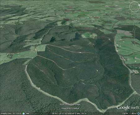
Power Transmission Lines running through Hancock plantations in the Haunted Hills and south west of Moe. Approximately 13km of major power lines run through Hancock plantations in Gippsland. The dangers of fires and these transmission lines was raised in the 2009 Boolara bushfires where plantation fires came within 2km's of the lines.
Plantations and main powerlines transmitting power from Hazelwood Power Station to Melbourne
Australia's largest plantation fires (uncompleted)
February 16 1983: South Australia 23,000ha
February 7 2009: Strzelecki Ranges 10,706ha
2003: Canberra (ACT)10,500ha
2006: Tumut (NSW) 9,000ha Billo Road Fire
1983: Bombala (NSW)6457ha
2014: Minninbah (NSW) 2000ha?
1958: April: 8 firefighters lose their lives in a plantation fire at Wandilo South Australia
Canberra pine plantations go up in smoke