Region: Otways
Legal Number: LEGL/93-44
Plantation: Boonah
Conservation Priority: Med
Approximate Size: 450ha
|
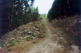 93-44a Feb 01: Retreat Valley
Road. Otways soils are very dispersive and are similar to
those of the Strzeleckis. This means that good road construction
is vital.
93-44a Feb 01: Retreat Valley
Road. Otways soils are very dispersive and are similar to
those of the Strzeleckis. This means that good road construction
is vital. |
|
Plantation within AKD Softwoods area of supply.
Plantation within SPE Exports (Geelong) area of supply.
Portion on plantation borders Painkalac Creek (Airey’s Inlet) Water
Supply Catchment. Proclaimed 13/5/81.
Land System: Forrest Rainfall: 900-1100mm
Landscape: Deeply dissected Hills
Native Vegetation: Open Forest: E. Obliqua,
E. radiata, E. cypellocarpa. Tall Open Forest: E. cypellocarpa, E. obliqua.
Soils: Brown Duplex soils; brown gradational
soils.
Forms of Soil Deterioration: Sheet and Landslip
erosion.
Herbicides Used by Hancock
in Pine Plantations - Ballarat Region Victoria
| Herbicide |
Label Rate max as kg/ha |
Used to control |
Notes |
Application |
| Clopyralid |
2.55 |
Woody Weeds |
Highly Toxic/Potential Ground water Contaminant |
air or ground |
| Glufosinate
Ammonium |
1 |
Woody Weeds |
|
|
| Glyphosate |
3.6 |
Herbaceous and woody weeds, noxious weeds |
|
|
| Hexazinone |
4 |
Woody Weeds |
Ground Water Contaminant |
Aerial, ground, spot |
| Metsulfuron-Methyl |
0.06 |
Woody Weeds, Noxious Weeds |
Potential Ground Water Contaminant |
Aerial, ground or spot |
| Triclopyr |
3 |
Woody and Noxious Weeds |
|
Ground, spot, basal bark |
THREATENED FISH NOTES - BARWON RIVER: Probably Blackfish
in mid to upper reaches. The lower reaches have 1 of 2 of the main spawning
areas for Australian
Grayling west of Melbourne.
Responsible Authority: Surf Coast Shire Council/Colac-Otways
Shire Council
Quote of the year 2002: "Colac Otway Shire 6/12/02. Freedom
of Information Request.
In response to your request for information relating to the use
of herbicides by plantation companies, I advise that there are no records
within Council, as plantation companies are not yet required to advise
either Council or the Department of Natural Resources and Environment
of their intention to conduct herbicide applications.
Yours sincerely - Freedom of Information Officer - Colac Otway Shire".
Plantation Catchment: HW of Several tribs of unnamed creek that
flows into Retreat Creek/Barwon River.
Catchment Managment Authority: Corangamite Catchment Management
Authority
Hancock Watch Site visit Feb 01: Entered the plantation from
the east side along Retreat Valley Road. Drove along road and saw very
poor examples of roading, where the batters were eroding away in front
of me - in the late summer! Took many photos highlighting poor quality
of roads, culverts and drains. This road will be a disaster in the wet
months - especially when the area is to be logged. Slopes appeared to
vary from OK to 20 degrees - however erosion potenial bound to be large.
Very few signs of native vegetation except some remnant trees along
Retreat Creek.
Other notes: A study of the Land in the catchments of the Otway
Range and Adjacent Plains - Soil Conservation Authority 1981.
p143 "Both establishment and harvesting of hardwood and softwood
forests cause serious changes to the natural hydrological balance. Pine
establishment on disused agricultural land and previously forested land
has led to widespread deterioration. The steep north and west facing
slopes of Lorne, Forrest, Moggs Creek, Aire, Mt Mackenzie, Bunker Hill
and Yahoo Creek land systems are the most severely affected.
Sheet erosion losses can be minimised by working in coupes along the
contour, and by maintaining adequate vegetative cover with litter layers
over the soil surface. The incidence of landslips increases following
harvesting, when the binding effect of tree roots is removed and the
soil is subject to saturation for longer periods. The study area share
the current trend to reduce the total area of productive forest land
and manage this smaller area for higher yields. As with agriculture,
nutrients removed in forest produce need to be replaced through the
use of fertilisers. The fertiliser requirements of soils designated
for long-term hardwood and softwood production require investigation.
p142 Steep slopes in and around drainage lines are more stable under
hardwood than softwood forestry, because of longer growth period and
more selective logging practices.
Barwon River above Winchelsea: Usually a slow flowing river with
extensive shallow reaches and pools up to 2.5m deep. Flows from moutainous
forested country upstream of Forest to grazing land, sand and mud bottom.
Lower section modified by agriculture and flow is controlled by water
releases from West Barwon Reservoir. Trout spawning occurs in the headwaters.
Contains river blackfish to 140g, some brown trout to 600g, redfin,
short-finned eels and spiny freshwater crayfish.
Source: A G uide to the Inland Angling Waters of Victoria by BR Tunbridge,
PL Rogan, CA Barnham. Department Conservation and Environment. Arthur
Rylah Institute for Environmental Research, 123 Brown St, Heidelberg,
3084. (4th ed - 1991)
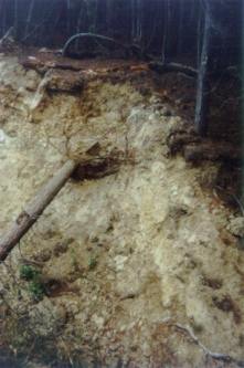 93-44b Feb 01: Retreat Valley
Road - Pine falling onto road due to eroding soil.
93-44b Feb 01: Retreat Valley
Road - Pine falling onto road due to eroding soil. |
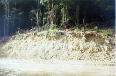 93-44c Feb 01: Retreat Valley
Road - High erosion potential. What will happen to this area after
a heavy rainfall?
93-44c Feb 01: Retreat Valley
Road - High erosion potential. What will happen to this area after
a heavy rainfall? |
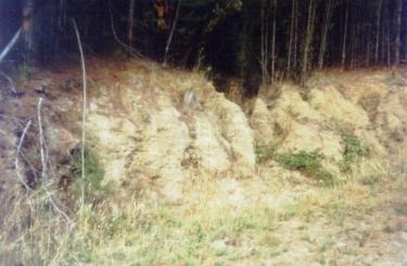
 93-44d Feb01: Retreat Valley
Road - High erosion potential. Shot taken in mid-summer.
93-44d Feb01: Retreat Valley
Road - High erosion potential. Shot taken in mid-summer. |
 93-44e Feb 01: Retreat Valley
Road - High erosion potential
93-44e Feb 01: Retreat Valley
Road - High erosion potential |
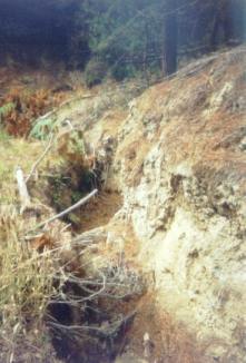 93-44f Feb 01: Retreat Valley
Road - Erosion of drain alongside logging road.
93-44f Feb 01: Retreat Valley
Road - Erosion of drain alongside logging road. |
HOME
|