Plantation within Dominance Industries (Alpine MDF Industries) area of supply. Plantation within D & R Henderson/Monsbent area of supply. North East Victoria Plantation Map here
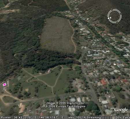
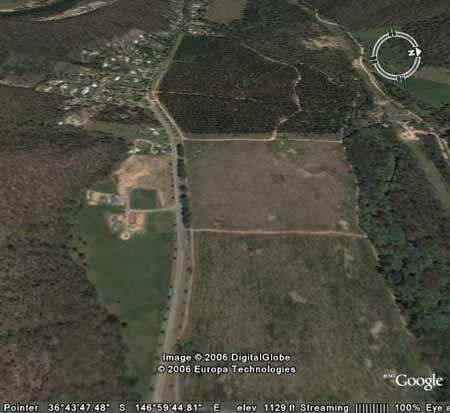
Racecourse Plantation: purple mark indicates Ovens River pump station, located just downstream from plantation. This plantation was very likely to be sprayed with 2,4,5-T between 1968 and 1977. The Dioxin TCDD may still exist in soil in this plantation. For more historical data on 2,4,5-T click here. For more information concerning the continuing health crisis concerning 2,4,5-T please forward to here.
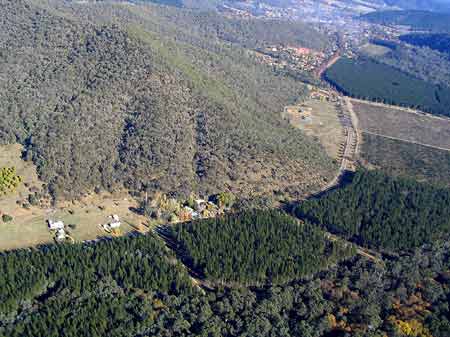
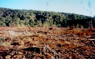
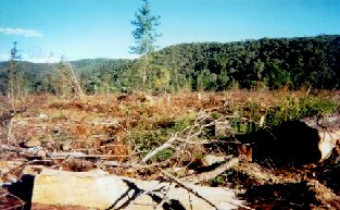
Another portion of the plantation. Plantation in very close proximity to Bright. Source: Melbourne University School of Resource Management Land & Food Resources. Herbicides Used by Hancock in Pine Plantations - North East Region Victoria
Proclaimed Water Catchment Area: This plantation area is located in the Ovens River (Bright) Water Supply Catchment.
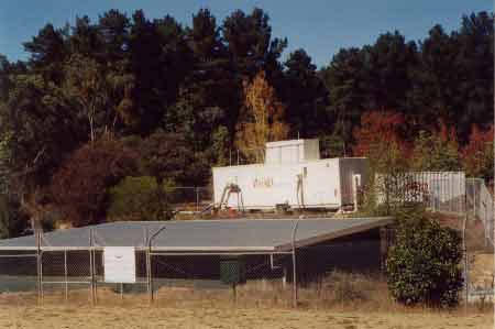
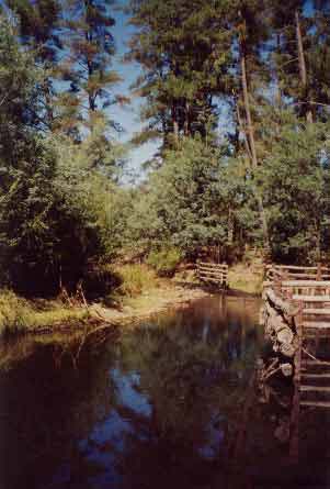
This plantation lies about 100 metres upstream from North East Region Water Authority's Ovens River Pump Station and Chlorination Plant (Bright's drinking water). Note pine trees in background which stand next to Hancock plantation. The plantation extends for 3km along the banks of the Ovens River. OVENS RIVER CATCHMENT SUPPLIES WANGARATTA AND BRIGHT WITH WATER. MURRAY
RIVER SUPPLIES WATER TO YARRAWONGA, COBRAM, BARMAH, ECHUCA , KERANG,
PIANGIL, SWAN HILL, ROBINVALE, MILDURA
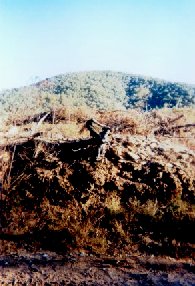
Ex Gold Mining Area: According to http://www.alpinelink.com.au "Stripped of its gold and plant cover, the land on both sides of the river had been left in a severely degraded state, even though the companies had promised to replace the topsoil. In 1916 this was the site of the first experimental pine plantings to reclaim a dredged area. This test planting showed that Radiata Pine survived well and other dredge tailings, began being restored by planting them with pines. Their success led to the establishment of commercial pine plantations on non-mined areas". Gold was also worked on the spur between the Ovens River and German Creek. Responsible Authority: Alpine Shire Council
The Ovens River just upstream
from the offtake point for Brights' drinking water. Hancock's plantation
starts just next to large pine trees in photo. ‘A Report on the Ovens River (Bright) Water Supply Catchment - Soil Conservation Authority 1984’ p3 “The Ovens River catchment point at Bright covers an area of 350km2 and lies to the south-east of the town. . . Bakers Gully, a proclaimed catchment, lies to the south of Bright but is not contiguous with the Ovens River (Bright) Catchment. . . The original Bright town water supply was provided from two reservoirs in Bakers Gully, the lower constructed in 1900 and the higher in 1912. A pump on the Ovens River and rising main connecting into the town distribution system was installed in the early 1960’s, to both offset and decrease in effective storage capacity in the Bakers Gully storages which had occurred through silting, and to satisy the demand due to increases in the permanent and tourists peak populations of the town. The pumping facility at the offtake was subsequently expanded and is currently the sole source of water supply for the town. . . Although the greater part of the catchment is forested, from Harrietville the river passes through residential areas, cultivated crops, grazing land and pine plantations before reaching the offtake site within Bright township . . . p4 . . . Dissolved salt, colour and turbidity values are low to very low. Quality overall is good for a river with a multiple-use catchment. The water supply is chlorinated at the pumping station . . . Mean annual rainfall for Bright is 1103mm and increases to more than 2000mm, due to the influence of elevation and topography, as one ascends the catchment. During winter months most of the catchment with elevations above 1500m receives its precipitation as snow and, in a normal winter, snow accumulates from June to September. High intensity storms are of short duration and occur mainly in summer. . . p5 . . . The river valley below Harrietville is mature, surrounded by a hilly and mountainous area of Ordovician mudstones, shales and sandstones, with Quaternary deposits of gravel and alluvium on the valley floor. The area shows mature dissection with long, sharp ridges. The streams have a dendritic drainage pattern. Hillwash deposits (colluvium) and stream alluvium have been extensively distrurbed by gold-dredging . . . Friable brown and red gradational soils are present on the Ordovician sediments. On the steep slopes and northern aspects, the soils are commonly red and stony red gradational types with shallow profiles - often skeletal . . . On the colluvium and alluvium which is found mostly along watercourses a number of different soils are found. Predominant soils are the red duplex types, friable gradational types and weakly bleached red-brown and yellow gradational soils. The past operation of floating dredges in the Ovens Valley as far as Harrietville has resulted in a re-sorting of alluvium obtained from depths as great as 25 m and more below the surface, and the deposition of stones and cobbles at the surface . . . Much of the land on the valley floor between Harrietville and Bright has been cleared and sown to pasture. The extensive dredged areas have, in the vicinity of Bright and Freeburgh, been planted to softwoods and elsewhere restored where possible . . . In the northern portion of the catchment some of the foothill country has been used to grow softwoods. . . p6 . . . Mining has played an important part in the history of the area. Gold was first discovered at Harrietville in 1852, with quartz reef mining commencing in the 1860’s. The operation of floating dredges in the valley was extensive and continued at Harrietville and Freeburgh until the 1940’s . . . p7 . . . Erosion from disturbed sites in or close to streams and the removal of ground-cover over extensive areas by wildfire are the greatest potential hazards to water quality. Disturbances may arise through farming activities, clearing, or forest operations (roading, logging). Turbidity and sedimentation of the water is not currently a problem, however, the impacts of disturbance being relatively short-lived . . . No camping is permitted in the Forests Commission (now Hancock) pine plantations near Bright between 15 November and 30 April as a fire protection measure, with the additional benefit of reducing human impacts on water quality. The Bright Waterworks Trust prohibits camping in the immediate vicinity of the offtake at all times . . .” “Special Investigation: North-Eastern Victoria - Ovens Softwood Plantation Zone. Land Conservation Council 1981. p12 The northern plains region The north-west of the study area towards Wangaratta contains part of
the extensive riverine plains. The plains, which border the major streams
such as the King and Ovens Rivers and their tributaries, consist of
alluvial deposits, often more than 50m deep. Alluvial fans occur along
the foothill margins, and features such as river terraces and ox-bow
lakes, typical of a riverine flood plain occur along the major river
valleys. The river terraces are characterised by uniform sandy loams
and gradational soils, while the alluvial sediments of the fllod plain
are duplex soils, usually consisting of a sandy loam overlying a clay
subsoil. These soils are found in all major river valleys throughout
the study area. . .”
|