Plantation within Australian Newsprint Mill (ANM) Ltd area of supply.Plantation within Dominance Industries (Alpine MDF Industries) area of supply. Plantation within D & R Henderson/Monsbent area of supply. Plantation within Benalla Timber area of supply.
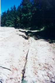
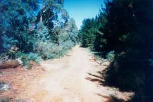
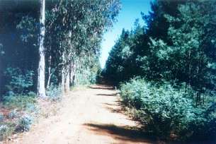
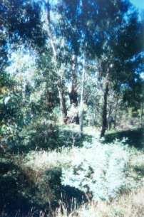
January 2010: Recent plantation logging in Ryans Creek domestic water supply Strathbogies and Central North East Plantation Map here Water Catchment Area: Ryan’s Creek Catchment (Benalla Water Supply). Land Use Determination (LUD) 30/10/74. LUD’s replaced with Special Area Plan’s under the Catchment and Land Protection Act 1994.Incomplete Herbicide Regime:Spring/Summer 1993: 100 hectares sprayed by the Victorian Plantation Corporation with 875.5 Litres of Lontrel L in order to kill predominantly Silver Wattle, >3m high in stands of 500-2500 sph. Herbicides Used by Hancock in Pine Plantations - North East Region Victoria
MURRAY RIVER SUPPLIES WATER TO BARMAH, RUTHERGLEN, ECHUCA , KERANG, PIANGIL, SWAN HILL, ROBINVALE, MILDURA THREATENED FISH NOTES - BROKEN RIVER: Downstream of Nillacootie there is a remnant population of Macquarie Perch. Yellow Belly and Murray Cod are also stocked into the Broken River. Holland and Ryans creek both have populations of Macquarie Perch especially in Holland Creek. In regard to Ryans Creek above Loombah Weir it is the first time that a stocked population of Trout Cod has been found to be spawning.
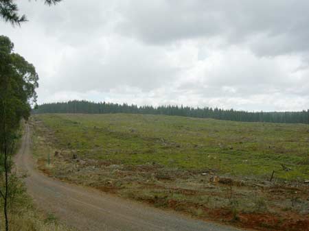
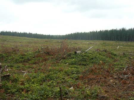
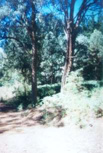
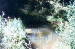
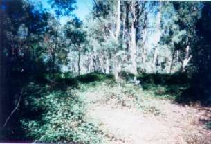
January 2010 Blackberry infestation remains post logging. Responsible Authority: Delatite Shire Council Plantation Catchment: Ryans Creek and HW Whiskey Creek/Ryans Creek/Holland Creek/Broken River. Catchment Managment Authority: Goulburn Broken Catchment Management Authority Hancock Watch Site visit Mar 01: Important plantation for water quality reasons. Noticed some quite poor roading with erosion potential on roads on the eastern side/Ryans Creek side of the plantation. Saw some evidence of buffers zones on tribs feeding into Ryans Creek - and also saw potential poor quality water sitting in a pool on one of the tribs of Ryans Creek (Needed a water quality monitoring kit). Also saw some potential water quality issues with a trib of Whiskey Creek which flows directly into McCallsay Reservoir. Saw evidence of OK buffer zones in the north side of the plantation and also evidence of blackberry infestation. A couple of areas of native vegetation still exist inside this plantation. April 03: Recent roadworks occurring in plantation some thinning going ahead. Other notes: ‘Report on the Ryan’s Creek Catchment (Benalla Water Supply) Soil Conservation Authority 1970’. “Benalla’s water comes from the 600 acre feet capacity Loombah Weir, situated on the Upper Ryan’s Creek about 19 miles south-east of Benalla . . . The catchment is situated on the northern flank of the Tolmie Highlands. From Loombah Weir to Archerton the distance is about 13 miles. The catchment with an average width of about 2.5 miles has an area of about 30 square miles . . . it can be said that the rainfall of this catchment is erratic, arrives in heavy storms... The high precipitation comes from very high falls of winter and spring rains caused by elevation of the rainbearing clouds over the ranges...” “Geologically the main features are the Upper Devonian age porphyritic dacites. But for the head-water area around Archerton, which is on older basalt, the bulk of the catchment is on the acid igneous type rocks. The dacites, although similar in appearance to granite, produce significantly different soils... The second unit extends roughly over the central section of the area where the valley widens. The topography consists of more gently dissected plateau areas with wider ridge tops and with slopes moderately steep... (ii) Central Unit: Acid Brown Earths are typical soils of the broad ridge tops and less steeply dissected areas of moderate altitude. The soils are leached, but not podsolised, the profile depth depends very much on the topographic position. From a dark brown loam of blocky structure the profile grades into lighter colours with increasing clay content remaining however, friable and well drained. The permeability of this soil, unless reduced by fire or compaction is such that surface runoff occurs only after prolonged wet periods. . . The vegetation consists of a wet sclerophyll forest of Narrowleaf Peppermint with Candlebark and Messmate stands. . .” “...In the Central Unit the erosion hazard is fairly low, mainly due to the good permeability of the soils. Apart from local logging damage there is no discernible erosion except where tracks are left without drainage provision...” Ryans Creek (Above Loombah Weir): A fast flowing stream, in forested country, gravel and rock bed. Some siltation from forestry activities. Carries mainly small brown trout, river blackfish and trout cod. Stocking of trout cod commenced in 1988 as part of the Department's program to establish another population of this endangered native fish. Results of this program appear to have been very successful with trout cod to 400g being recovered in 1990. Ryans Creek, Benalla: An excellent trout stream above Loombah and Mccall Say Weirs, but access is difficult because of overhanging vegetation. Spiny freshwater crayfish and brown trout occur throughout the stream. Loombah and Mccall Say Weirs are domestic water supplies, closed to fishing. Source: A Guide to the Inland Angling Waters of Victoria by BR Tunbridge, PL Rogan, CA Barnham. Department Conservation and Environment. Arthur Rylah Institute for Environmental Research, 123 Brown St, Heidelberg, 3084. (4th ed - 1991) The distribution of Trout Cod is more restricted than in the past (Cadwallader &Gooley 1984). They were once widespread in the Murray-Darling system, mostly in the upper reaches (e.g. Mitta Mitta, Ovens, King and Goulburn Rivers), though recorded as far downstream as Mannum in South Australia (Cadwallader & Backhouse 1983, Cadwallader & Gooley 1984). In Victoria the only known viable population occurs in Seven Creeks, upstream of Euroa between Gooram Falls and Polly McQuinns Weir, and originates from fish translocated from the Goulburn River in 1921 and 1922. The Department of Conservation and Natural Resources (CNR) and its predecessors have released fish into Koetong, Hughes, Ryans and Buffalo Creeks and the Coliban and Broken Rivers. There are also unconfirmed reports of Trout Cod in a number of waters, including the King, upper Ovens, and lower Goulburn Rivers, and Cutting, Narial, Cudgewa, Morses and Broken Creeks.
|