Region: OvensLegal Number: LEGL/93-154/1Plantation: Cropper CreekConservation Priority: High |
| Herbicide | Label Rate max as kg/ha | Used to control | Notes | Application |
| Carfentrazone-Ethyl | 0.036 | |||
| Clopyralid | 2.55 | Woody Weeds | Highly Toxic/Potential Ground water Contaminant | air or ground |
| Glyphosate | 3.6 | Herbaceous and woody weeds, noxious weeds | ||
| Hexazinone | 4 | Woody Weeds | Ground Water Contaminant | Aerial, ground, spot |
| Metsulfuron-Methyl | 0.06 | Woody Weeds, Noxious Weeds | Potential Ground Water Contaminant | Aerial, ground or spot |
| Triclopyr | 3 | Woody and Noxious Weeds | Ground, spot, basal bark |
OVENS RIVER SUPPLIES WANGARATTA WITH WATER. MURRAY RIVER SUPPLIES WATER TO YARRAWONGA, COBRAM, BARMAH, ECHUCA , KERANG, PIANGIL, SWAN HILL, ROBINVALE, MILDURA
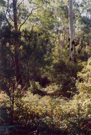
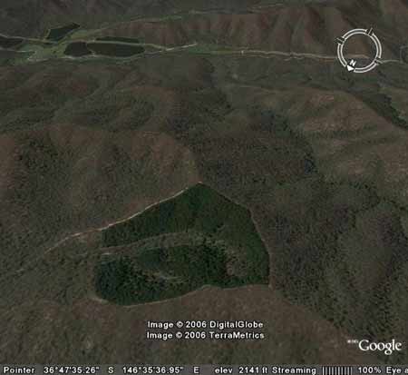
Beautiful buffer zone of Cropper
Creek. It's a pity that more of Hancock's north east plantations aren't
as impressive as this. Old growth
can be found in this buffer - thus the plantation is warranted a high
conservation importance.
THREATENED FISH NOTES - OVENS RIVER: Most important river in
Victoria in regard to the survival of the Murray
Cod. Murray
Cod spawn almost as far up as Myrtleford
and the Ovens supplies recruitment for the Murray River as well. The
Ovens has no dams and is a river of extreme national significance. Trout
Cod are now being found in the Ovens
and may set up a self sustaining spawning population. Trout
Cod have been successfully stocked into
Ovens and upper Ovens, downstream of Myrtleford and going up the King
River - past Moyhu. All the tribs of the Ovens are important for native
fish including King, Buffalo and Buckland Rivers.
Responsible Authority: Alpine Shire Council?/Wangaratta Shire
Council
Plantation Catchment: Several tributaries flowing north into
Cropper Creek and Cropper Creek north branch/Lake Buffalo/Buffalo River/Ovens
River. Several tributaries of Clem Creek.
Catchment Managment Authority: North East Catchment Management
Authority
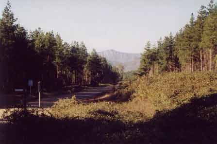
View looking east towards Mount Buffalo. Minimal slope problems are evident in this plantation.
Other notes: A Report on the Buffalo River - 1984. Soil Conservation Authority.
"Lake Buffalo construction was completed in 1965. It is used for irrigation. p3 Soils: predominantly hilly and mountainous area of Ordovician mudstones, shales and sandstones, with massive granitic intrusions at Abbeyard, Mt Emu and principally Mt Buffalo . . . p8 Erosion from disturbed sites in or close to streams and the removal of ground-cover over extensive areas by wildfire are the greatest potential hazards to water quality. Some disturbances may arise through farming activities, clearing, or forest operations (roading, logging)...”
“Special Investigation: North-Eastern Victoria - Ovens Softwood Plantation Zone. Land Conservation Council 1981.
p11 Central Region To the north and east of the Eastern Boundary Fault lies an extensive area of mountainous terrain composed of Ordovician sandstones and mudstones that are less resistant to erosion than the rocks of the south-western region. The drainage pattern is dendritic and the streams are seperated by sharp ridges and spurs. The mountains to the south of Mount Buffalo are typical of this region, which extends east to Mount Beauty and north to Myrtleford.
In the north-west around Moyhu and Bobinalwarral the ridges of Ordovician sediments become buried beneath the alluvial deposits of the riverine plain. Within the region, exposures of granitic rocks have intruded into the surrounding Ordovician sediments. Intense heat associated with the intrusions has altered (or metamorphosed) the adjacent sedimentary rocks. The granite outcrops at Mount Buffalo and Mount Emu are extremely resistant, while the surrounding sedimentary rocks which are less resistant have been deeply dissected.
In contrast, the granite in the Pinnacles area to the east of Myrtleford
is more susceptible to weathering and erosion and as a consequence the
terrain in this area is more subdued. A ridge of metamorphic rocks borders
Happy Valley to the east of Myrtleford. Friable reddish and brownish
gradational soils occur on the Ordovician sediments of this region,
while the granitic rocks of Buffalo Plateau and Mount Emu exhibit a
variety of soil types. Stony loams are characteristic of rocky outcrops
while poorly drained sites contain organic loams and peats. Sandy loams
and friable gradational soils are found on the lower slopes of these
intrusions. The less resistant granitic rocks at the Pinnacles and Abbeyard
carry a variety of gradational soils on the upper slopes and a range
of duplex soils at lower elevations. The gradational soils are suitable
for softwoods, but the poorly drained duplex soils are not.
Ovens River: The rivers all flow north, from heavily forested
mountain country through excessive river flats to the Murray River.
Murray cod populations close to the Murray River. Small river blackfish
are common in many rivers, Macquarie Perch are still occasionally caught,
and catches of golden perch are also being reported. Brown trout widely
distributed through system with rainbow trout most abundant in upper
reaches.
Buffalo Lake - Dandongadale: A deep water storage surrounded
by cleared land. A poor producer of trout for some unknown reason. Adult
Macquarie Perch translocated in 1981 and 1991 to bolster the remnant
population in the lake. Wide fluctuations in water level. Contains some
brown trout to 2kg and rainbow trout to 550g, also abundant redfin,
some to 1.7kg, goldfish and some Macquarie Perch. Also possibly an occasional
Murray Cod. Trout spawn in the Buffalo River above the lake.
Source: A Guide to the Inland Angling Waters of Victoria by BR Tunbridge,
PL Rogan, CA Barnham. Department Conservation and Environment. Arthur
Rylah Institute for Environmental Research, 123 Brown St, Heidelberg,
3084. (4th ed - 1991)