Plantation within Dominance Industries (Alpine MDF Industries) area of supply. Plantation within D & R Henderson/Monsbent area of supply. North East Victoria Plantation Map here
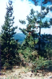
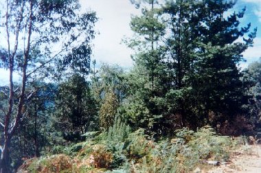
Plantation in very close proximity to Bright. Source: Melbourne University School of Resource Management Land & Food Resources. This plantation was very likely to be aerially sprayed with 2,4,5-T between 1968 and 1977. The Dioxin TCDD may still exist in soil in this plantation. For more historical data on 2,4,5-T click here. For more information concerning the continuing health crisis concerning 2,4,5-T please forward to here. Herbicides Used by Hancock in Pine Plantations - North East Region Victoria
Declared Water Catchment Area: This plantation area is located in the Bakers Gully (Bright) Water Supply Catchment. Proclaimed 13/6/79. Old Gold Mining Site: One gold reef 'Walkers' was worked and replanted with pine in the 1920's in Bakers Gully. OVENS RIVER CATCHMENT SUPPLIES WANGARATTA AND BRIGHT WITH WATER. MURRAY RIVER SUPPLIES WATER TO YARRAWONGA, COBRAM, RUTHERGLEN,ECHUCA , KERANG, PIANGIL, SWAN HILL, ROBINVALE, MILDURA
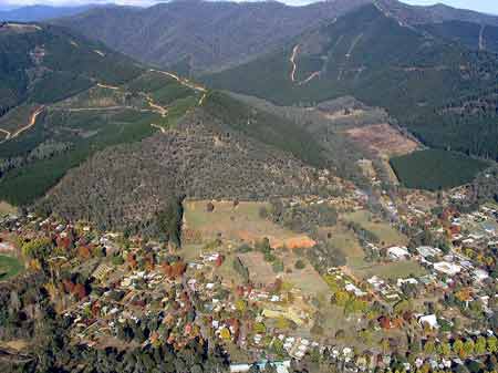
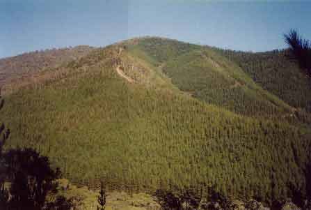
LEGL93-129: Looking south into
Bakers Gully plantation from Apex Lookout. Photo shows large area of
native vegetation to the south. This native vegetation is also under
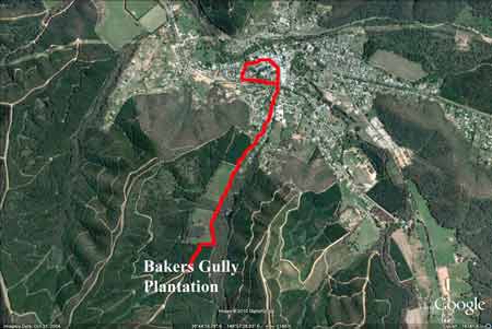
Hancock control. Bakers Gully Timber Haulage Route Mar - Apr 2011 [http://www.alpineshire.vic.gov.au/Files/Council_meetings/M113November2010Agenda.pdf] Proposed Haulage Route: Will require log trucks to travel past the Bright p-12 College down Bakers Gully Rd, through the roundabout, down Ireland Street to Anderson Street and onto Gavan Street with the return route from Gavan Street, Station Street, Railway Avenue around the roundabout and up Bakers Gully Roads past Bright P-12 College and continue to the plantation log storage site.
Log Truck Route straight into the middle of Bright.
Gotta love that diesel in the middle of Autumn!
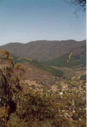
Photo looking at the western face of Bakers Gully showing extent of pine. Other Notes: �A Report on the Bakers Gully (Bright) Catchment. A Proposal for Proclamation Prepared for Consideration by the Land Conservation Council - 1978 - Soil Conservation Authority.� Bright Water �Supply at present is drawn from two reservoirs in Bakers Gully. However, the creek in Bakers Gully ceases to flow for several months in normal years. The supply is supplemented during the dry periods by pumping from the Ovens River direct into the reticulation system . . . The reservoirs have silted up significantly and become over-grown with vegetation since construction, particularly the higher one. This is attributed to the effects of forestry operations and perhaps more importantly the 1939 fires . . . Bakers Gully is the best source of good quality water close to the town . . . Bakers Gully is situated on silty quartz sandstone and grey-wacke, argillaceous and sandy siltstone, shale and mudstone of Middle to Upper Ordovician age. The fresh rock is a grey colour whereas the weathered rock is yellow-brown or brown. The sediments have been converted into low-grade metamorphics, especially changing shale to slate. Also the beds have been compressed into closely spaced meridional anticlines and synclines which provided a major structural control on quartz reef location and gold deposition in this area. Minor hillwash deposits (colluvium) and stream alluvium are found mainly in the lower catchment area. Friable brown and red gradational soils are present on the Ordovician sediments which includes most of the catchment. A typical profile of the former has a litter layer 5 - 10cm thick overlying a dark-brown friable loam with strongly developed fine structure. With increasing depth the colour becomes paler as the influence of organic matter decreases, then usually more reddish or stronger brown. Textures change to clay loam or light clay. A typical profile of the latter commences with about 6cm of dark-brown loam over about 8cm of yellowish red or reddish-brown loam to clay loam that merges with depth into the dark red or reddish-brown light clay. This soil is well structured at the surface but the rest is medium sub-angular blocky that breaks to very fine subangular blocky at deeper levels. Both these soils show moderate sheet erosion. Damage by fire, roading and logging can lead to changes in hydrological performance resulting in increased peak flows and stream turbidity. On the colluvium and alluvium which is found mostly along the watercourses a number of different soils are found, due mainly to the varying texture and make-up of the parent material. Those present are red duplex soils, friable gradational soils, weakly bleached, red-brown and yellow gradational soils. They have low to moderate sheet and gully erosion hazard. Vegetation: Native vegetation remains in the upper half of the catchment (4.4 sq km) with the lower half being planted to softwoods (2.7 sq km) mainly prior to the 1939 fires. The upper half of the catchment consists mainly of open forest with broad-leaf peppermint occurring mainly on the ridges associated with red stringybark, red box and long-leaf box. As elevation and rainfall increase, candlebark and brittle gum replace the red stringybark. The understorey is made up of shrubs, herbs and grasses. The broad-leaf peppermint is typically replaced by narrow-leaf peppermint in the sheltered valley areas. Associated tree species are candlebark, manna gum and blue gum in the gullies and broad-leaf peppermint, brittle gum and red stringy-bark on the drier areas. Shrubs, grasses and herbs are found in the lower strata. Climate: The average rainfall for Bright is 1103mm . . . High intensity storms are short and mainly occur in the summer. Land Use and Tenure: In 1875 the Department of Crown Lands and Survey temporarily reserved 768 ha for water supply purposes and in 1893 this area was put under the temporary management of the Bright Waterworks Trust. In 1924 the Forest Commission was given permission to use the land for planting of pines. The Trust had no objection to this proposal at the time on the understanding that the Commission would cause no contamination of the water. The most significant use of land within the catchment is softwood production which embraces 37% (274ha) of the catchment to the existing reservoirs, but only 11% (51ha) of the catchment to the proposed new reservoir. The Forest Commission is aware of the potential problem which exists in the catchment during logging operations and in the more recent past has altered its proposed plans of operation at the request of the Trust in order to help protect the water quality. . . Hazards to the Water Supply: The erosion hazard in the catchment consists of potential moderate sheet erosion on the slopes. Softwood extraction and roading accentuate this hazard. The other hazard which causes concern is the possibility of pathogens entering the water supply due to the relative ease with which people and domestic and wild animals can gain access to the storage reservoirs . . .� �Special Investigation: North-Eastern Victoria - Ovens Softwood Plantation Zone. Land Conservation Council 1981. p11 Central Region To the north and east of the Eastern Boundary Fault lies an extensive area of mountainous terrain composed of Ordovician sandstones and mudstones that are less resistant to erosion than the rocks of the south-western region. The drainage pattern is dendritic and the streams are seperated by sharp ridges and spurs. The mountains to the south of Mount Buffalo are typical of this region, which extends east to Mount Beauty and north to Myrtleford. In the north-west around Moyhu and Bobinalwarral the ridges of Ordovician sediments become buried beneath the alluvial deposits of the riverine plain. Within the region, exposures of granitic rocks have intruded into the
surrounding Ordovician sediments. Intense heat associated with the intrusions
has altered (or metamorphosed) the adjacent sedimentary rocks. The granite
outcrops at Mount Buffalo and Mount Emu are extremely resistant, while
the surrounding sedimentary rocks which are less resistant have been
deeply dissected. In contrast, the granite in the Pinnacles area to
the east of Myrtleford is more susceptible to weathering and erosion
and as a consequence the terrain in this area is more subdued. A ridge
of metamorphic rocks borders Happy Valley to the east of Myrtleford.
Friable reddish and brownish gradational soils occur on the Ordovician
sediments of this region, while the granitic rocks of Buffalo Plateau
and Mount Emu exhibit a variety of soil types. Stony loams are characteristic
of rocky outcrops while poorly drained sites contain organic loams and
peats. Sandy loams and friable gradational soils are found on the lower
slopes of these intrusions. The less resistant granitic rocks at the
Pinnacles and Abbeyard carry a variety of gradational soils on the upper
slopes and a range of duplex soils at lower elevations. The gradational
soils are suitable for softwoods, but the poorly drained duplex soils
are not.
|