Region: BENALLA/MANSFIELDLegal Number: LEGL/93-66/1Plantation: Mansfield FD
Conservation Priority: HighAlmost all of this plantation was burnt out in the January 2007 Tolmie fires.Strathbogies and Central North East Plantation Map here |
| Herbicide | Label Rate max as kg/ha | Used to control | Notes | Application |
| Carfentrazone-Ethyl | 0.036 | |||
| Clopyralid | 2.55 | Woody Weeds | Highly Toxic/Potential Ground water Contaminant | air or ground |
| Glyphosate | 3.6 | Herbaceous and woody weeds, noxious weeds | ||
| Hexazinone | 4 | Woody Weeds | Ground Water Contaminant | Aerial, ground, spot |
| Metsulfuron-Methyl | 0.06 | Woody Weeds, Noxious Weeds | Potential Ground Water Contaminant | Aerial, ground or spot |
| Triclopyr | 3 | Woody and Noxious Weeds | Ground, spot, basal bark |
Water Catchment Area: KING RIVER CATCHMENT. DRINKING WATER FOR MOYHU, OXLEY. MURRAY RIVER SUPPLIES WATER TO YARRAWONGA, COBRAM, RUTHERGLEN, BARMAH, ECHUCA , KERANG, PIANGIL, SWAN HILL, ROBINVALE, MILDURA
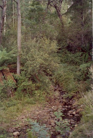
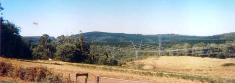
April 2003: Fifteen Mile Creek inside the plantation boundary. Decent buffers in places. How much water do Hancock's plantations use in this catchment?
THREATENED FISH NOTES - OVENS RIVER: Most important river in Victoria in regard to the survival of the Murray Cod. Murray Cod spawn almost as far up as Myrtleford and the Ovens supplies recruitment for the Murray River as well. The Ovens has no dams and is a river of extreme national significance. Trout cod are now being found in the Ovens and may set up a self sustaining spawning population. Trout Cod have been successfully stocked into Ovens and upper Ovens, downstream of Myrtleford and going up the King River - past Moyhu. All the tribs of the Ovens are important for native fish including King, Buffalo and Buckland Rivers.
THREATENED FISH NOTES - BROKEN RIVER: Downstream of Nillacootie there is a remnant population of Macquarie Perch. Yellow Belly and Murray Cod are also stocked into the Broken River. Holland and Ryans creek both have populations of Macquarie Perch especially in Holland Creek. In regard to Ryans Creek above Loombah Weir it is the first time that a stocked population of Trout Cod has been found to be spawning.
Responsible Authority: Wangaratta Shire Council/Delatite Shire Council
Plantation Catchment: 4 separate plantations Several creeks/tribs of
King River West Branch/King River/Ovens River.
Several creeks tribs of Fifteen Mile Creek/Ovens River
1 creek arm Ryans Creek/McCallsay Reservoir/Loombah Weir/Ryans/Holland
Creek/Broken River.
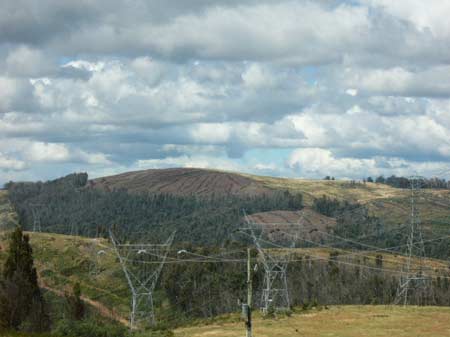
Hancock Watch Visit April 03: Recent roading in the Fifteen
Mile Creek catchment plantation revealed that logging will commence
in the catchment soon. It appeared that much of the main creek system
has decent enough buffers, but the real extent of buffer zone protection
will not be revealed until post logging. It was also evident that recent
thinnings of radiata pine had been carried out in the headwaters of
the Ryans Creek catchment.
April 2003: Impressive Buffer zone of Fifteen Mile Creek inside the Hancock plantation.
Catchment Managment Authority: Goulburn Broken Catchment Management Authority/North East Catchment Management Authority
Other Notes: ‘ Report on the Ryan’s Creek Catchment (Benalla Water Supply) Soil Conservation Authority 1970’.
“Benalla’s water comes from the 600 acre feet capacity Loombah Weir, situated on the Upper Ryan’s Creek about 19 miles south-east of Benalla . . . The catchment is situated on the northern flank of the Tolmie Highlands. From Loombah Weir to Archerton the distance is about 13 miles. The catchment with an average width of about 2.5 miles has an area of about 30 square miles . . . it can be said that the rainfall of this catchment is erratic, arrives in heavy storms... The high precipitation comes from very high falls of winter and spring rains caused by elevation of the rainbearing clouds over the ranges...”
“Geologically the main features are the Upper Devonian age porphyritic dacites. But for the head-water area around Archerton, which is on older basalt, the bulk of the catchment is on the acid igneous type rocks. The dacites, although similar in appearance to granite, produce significantly different soils... Approaching Archerton the creek turns from its northerly course first west, then in a generally south-eastern course into its headwater area. This gently rolling to mildly hilly country, at altitudes between 2500 and 3000 feet forms the third unit... Krasnozems, the deep red loams developed on the older basalt and other rock types at this rainfall and around th 3000 ft elevation. Krasnozems have much in common with the acid brown earth but are deeper, more friable and better structured. A typical profile has a chocolate, reddish-brown organic rich surface layer of 6 inches to 10 inches deep, merging very gradually to a paler red-brown clay loam which becomes more red and heavier in texture with depth.
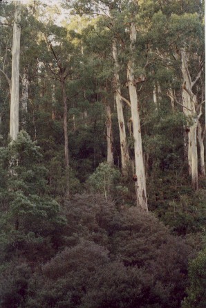
The soils are acid, highly leached, having about the same capacity to hold water as the acid brown earth. The vegetation in response to the climatic and topographic conditions of the area is of the wet sclerophyll forest type with Manna Gum, Messmate and Blackwood in the wetter areas, and Peppermint (narrow leaf) and Candlebark Gum on the drier sites. The understorey is daisy-bush, blanket leaf and Tree-ferns in the wetter gullies, while wattles and hazel are to be found on the drier sites. The floor layer is usually complete with tussock and creeping type grasses and herbs. Where the canopy has been opened-up the ground is covered by heavy stands of bracken-fern...
The Head-Water Unit is showing erosion in the areas where rabbits moved in and destroyed former pasture. The bracken which replaced the grass and has grown tall is not protecting the soil from the pounding of the rain which arrives in frequent and heavy storms”.
Report on ‘Fifteen Mile Creek and Glenrowan Service Reservoir Catchments (Glenrowan Water Supply) . Proposal for Proclamation - Soil Conservation Authority 1984’.
P2 “Water supply for the township of Glenrowan is taken from Fifteen Mile Creek . . . The water resources of the Fifteen Mile Creek Catchment are also used extensively for irrigation and for stock and domestic purposes . . . Developments within the higher section of the catchment, which is predominantly public land, have taken place over more recent years. This includes the conversion of some native forests to softwood plantations at the very top of the catchment . . . There are problems with stream sedimentation particularly at the offtake point on Fifteen Mile Creek. These problems appear to be increasing . . . p4 Fifteen Mile Creek is the most westerly of the main streams draining to the Ovens River . . .
Softwood plantations presently occupy 450 ha in the highlands. During the early establishment phase vigorous regrowth of silver wattle occurs on these areas necessitating broad-acre control measures. Presently aerial spraying of herbicides is the chief control measure, with ground spraying and manual clearing also used where appropriate . . . p6 The catchment supports a broad range of intensity of land uses and, in respect to water supply catchment values, complex issues surround some of these uses. Public concern has been expressed at the use of chemical sprays for controlling regrowth within the softwood conversion areas. Similar concern has been raised at the use of sprays and other agricultural chemicals associated with hop growing; also, cultivation and other activities adjacent to streams have been questioned, particularly where water frontage licences are issued. . . Expermental work concerning the effects of aerial spraying and stream water quality has been carried out by the Forests Commission.
Catchment Features: Plateau lower than 1200 metres - Land in this zone occupies areas chiefly above 770 metres, straddling boundaries with the adjacent catchments to the south, east and west. Maximum elevation within the catchment (1020m) occurs in this zone.
Upper Devonian acid lavas (predominantly rhyolite and rhyodacite), lower carboniferous sediments and remnants of Tertiary basalt are the principal components of a geological complex extending through the zone.
Red gradational or brown gradation type soils are the most common . . . The southern and most elevated section of the catchment receives an average annual rainfall of 1500mm . . .
p9 The forested upper catchment comprises mixed species forest, with narrow-leaf peppermint the dominant species in association with blue gum, candlebark, brittle gum, broad-leaf peppermint and red stringybark. Messmate stringybark is found on relatively “flat” plateau sites of the highlands where deep clays are present. Broad leaf peppermint forest occupies the poorer sites at the higher elevations . . .
p10 Potential Hazards to the Supply: Existing or potential concern affecting the supply are:
(ii) Low or non-existent summer flows.
(iv) The extensive network of unmade roads throughout the catchment which is considered to be a major source of silt and turbidity . . .
(vi) The possibility that herbicides used to control regrowth during the early years of softwood establishment, or sprays and agricultural chemicals used in farming and horticulture may find their way to the stream . . .”
The most easterly of these plantations (93-66/1) lie in the south-western region of the following report:
“Special Investigation. North-Eastern Victoria. Ovens Softwood Plantation Zone. Land Conservation Council 1981.
p10 The south-western region The eastern part of this region lies to the south of Cheshunt, and consists of a plateau of gently tilted upper Devonian and lower Carboniferous congolmerates. A fold axis on the eastern side of the plateau has produced a more rugged topography, particularly around Mount Typo and Mount Warrick. The plateau consists of friable reddish gradational soils, with undifferentiated sandy loams on the ridges and steeper slopes to the east. The lower slopes and foothills consist of friable brownish gradational soils . . .
The western part of this region is composed of resistant volcanic rocks of Devonian age capped in places by Tertiary basalts. Drainage within the region is afforded by the King River and its tributaries and Fifteen Mile Creek. The upper slopes and ridges on the Devonian volcanic rocks carry shallow stony loams and friable gradational soils, while the lower slopes and foothills consist of yellowish duplex soils. Reddish gradational soils have been developed on the isolated hill cappings of Tertiary basalt throughout the region. The gradational soils are generally suitable for the growth of softwoods. The eastern boundary of this region is marked by a major structural feature known as the Eastern Boundary Fault.”
Ryans Creek (Above Loombah Weir): A fast flowing stream, in forested country, gravel and rock bed. Some siltation from forestry activities. Carries mainly small brown trout, river blackfish and trout cod. Stocking of trout cod commenced in 1988 as part of the Department's program to establish another population of this endangered native fish. Results of this program appear to have been very successful with trout cod to 400g being recovered in 1990.
Fifteen Mile Creek, Wangaratta: A small creek flowing from forested country through grazing land, gravel and sand bed. Lower and middle reaches are badly silted and eroded. Rehabiliation works ongoing. Water extraction greatly depletes the water flow in summer. Trout are mainly restricted to the stream section which is in Crown land, and where suitable habitat is available. Contains mostly brown trout to 500g. Also a self supporting population of rainbow trout in the headwaters with abundant fish av. 150g and some larger fish to 900g. Abundant river blackfish. The lower reached tend to dry up in summer.
King River (Below Lake William Hovell): Length of stream suitable for trout has dimished greatly because of erosion, siltation and water and gravel extraction. This has also affected the Murray cod population in the lower reaches. Downstream to Moyhu brown trout are abundant average 400g, maximum 2.4kg, with river blackfish to 100g common, some redfin and carp, also very occasional Murray cod. Below Moyhu there are numerous redfin to 1.2kg and occasional Macquarie Perch and Murray cod to 5kg. Stocked regularly with brown trout by Department between Lake William Hovell and Edi.
Source: A Guide to the Inland Angling Waters of Victoria by BR Tunbridge, PL Rogan, CA Barnham. Department Conservation and Environment. Arthur Rylah Institute for Environmental Research, 123 Brown St, Heidelberg, 3084. (4th ed - 1991)
The distribution of Trout Cod is more restricted than in the past (Cadwallader &Gooley 1984). They were once widespread in the Murray-Darling system, mostly in the upper reaches (e.g. Mitta Mitta, Ovens, King and Goulburn Rivers), though recorded as far downstream as Mannum in South Australia (Cadwallader & Backhouse 1983, Cadwallader & Gooley 1984). In Victoria the only known viable population occurs in Seven Creeks, upstream of Euroa between Gooram Falls and Polly McQuinns Weir, and originates from fish translocated from the Goulburn River in 1921 and 1922.
The Department of Conservation and Natural Resources (CNR) and its predecessors have released fish into Koetong, Hughes, Ryans and Buffalo Creeks and the Coliban and Broken Rivers. There are also unconfirmed reports of Trout Cod in a number of waters, including the King, upper Ovens, and lower Goulburn Rivers, and Cutting, Narial, Cudgewa, Morses and Broken Creeks.