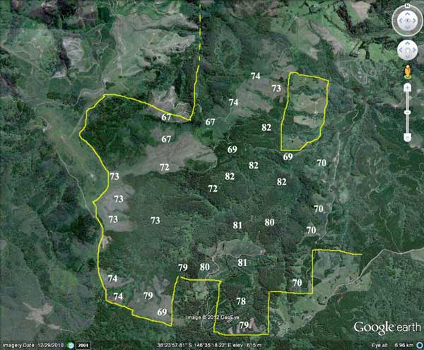
Plantation LEGL93-107 (between yellow lines), headwaters of Merrimans Creek and Flynns Creek, showing extent of plantations within catchment (numbers eg 76 refer to the year of plantation establishment). 500ha 245T, 150ha atrazine
Most (approximately 500ha) appear to have occurred between 1967-1974. It is highly likely thereforethat aerial application of 2,4,5-T @ 1.1 litres a hectare occurred. ~500ha would have been aerially sprayed with 2,4,5-T . Total amount used 1967-74 would have been 550L mixed with 25,000 litres of diesel. How much of this ended up in Merrimans Creek?
Post September 1976 a concoction of Amitrole (Weedagol T.L. Plus) and (Gesaprim 500) Atrazine may have been sprayed. In 2002 scientists in the United States found that Atrazine at levels as low of 0.1part per billion altered hormones in frogs. Since then Atrazine has been found to have the same effect across a range of animals. 150ha would probably have been sprayed with the Atrazine (4 l/ha/Amitrole 7l/ha) mixture. Totals 600 litres Atrazine, 1050 litres Amitrole).
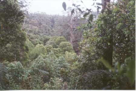
October 2001: Tributary on the western slopes of Merrimans Creek. Obviously non-plantation. Note old growth ash stags.
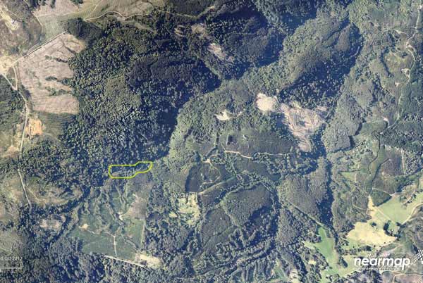
October 2012: Image courtesy of Nearmap: Merrimans Creek rainforest highlighted in yellow. Feb 09 fires came less than one kilometre from incinerating this rainforest remnant. Note extent of logging within catchment. A large portion of the headwaters of Merrimans Creek lies in the Strzelecki Cores and Links reserve.
Herbicides Used by Grand Ridge Plantations - Strzelecki Ranges and Gippsland Victoria
| Herbicide | Label Rate max as kg/ha | Used to control | Euc/Rad | Notes | Application |
| Clopyralid | 2.55 | Woody Weeds | Radiata and Eucalypts | Highly Toxic/Potential Ground water Contaminant | aerial or ground |
| Glufosinate Ammonium | 1 | Woody Weeds | Radiata | aerial or ground | |
| Glyphosate | 3.6 | Herbaceous and woody weeds, noxious weeds | Radiata, Eucalpts and Custodial | ||
| Haloxyfop-methyl | 0.13 | Annual and Pernneial Grasses | Eucalypts | Carcinogen | aerial or ground |
| Hexazinone | 4 | Woody Weeds | Radiata | Ground Water Contaminant | Aerial, ground, spot |
| Metsulfuron-Methyl | 0.06 | Woody Weeds, Noxious Weeds | Radiata, Eucalyptus and Custodial | Potential Ground Water Contaminant | Aerial, ground or spot |
| Sulfometuron Methyl | 0.6 | Annual and Perennial Grasses and broadleaf weeds | Eucalyptus | Potential Ground Water Contaminant | Aerial or Ground |
Soils according to 1978 Carrajung Geological Survey Map:
Kls: Cretaceous (Lower Aptian) Paludal - Strzelecki Group: Feldspathic, lithic sandstone, siltstone and mudstone, minor black coal, quartzose sandstone, conglomerate, local carbonate concentrations. Abundant plant remains.
Tvo: Palaeocene/Eocene: Dense augite and olivine basalt, tuff, claystone and siltstone. Often extremely weathered and ferruginized.
Tpc: Palaeocene: Coarse pebble conglomerate, coarse micaceous, feldspathic sand, minor fine micaceous sand and clay. Minor secondary silification.
Hancock Watch Site visit October 01: Supposed Plantation located on the northern slopes of the Grand Ridge Road - opposite Tarra Bulga National Park. The supposed plantation is approximately 4km west to east and just over 4km north to south. Its western boundary adjoins Mount Tassie. The area takes in almost all of the headwaters of Merrimans Creek and almost all the headwaters of Flynns Creek. There is a substantial amount of native vegetation between Merriman Creek Road and McBain Road, along Merriman Creek, which includes old growth ash and cool temperate rainforest dominated by Myrtle Beech, Sassafras and Blackwood. See Merrimans Creek rainforest site for further details.
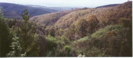
October 2001: View looking north west into Flynns Creek catchment with extensive native vegetation within Hancocks holdings. Plantation LEGL 93-105 is on left of photo.
A large stand of old blackwood and regenerating native forest can be found near the Silvester Track on the plantations eastern boundary. This area also includes the Duffs Sawmill Heritage Trail. There is also a substantial amount of native vegetation in the headwaters of Flynns Creek in the plantation areas north west edge. This vegetation appears to stretch for over one km, although recent logging has probably reduced its size somewhat. There is also a large expanse of hardwood plantation due east of the Callignee South Road - south of Callignee South. Some of this area is likely to be of high conservation significance - especially gully vegetation in the Merrimans Creek catchment.
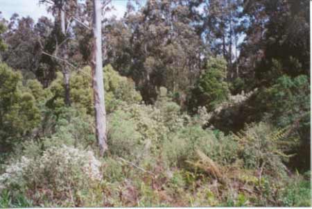
October 2001: Non plantation species within Flynns Creek catchment.
A large amount of native forest is also located in the northern aspect of the plantation. This native forest adjoins LEGL/93-105 along a tributary catchment of Flynns Creek. This area was accessed via Collins Track. Most of the native vegetation in the first 1-2km of Collins Track appeared to be regenerating messmate and mountain ash (although older trees were also evident). A couple of gullies were crossed by Collins Track and abysmal creek crossings (or lack of them) were evident at two gullies. One of these crossings may have been outside Hancocks area. The native forest areas within this plantation are obviously of high conservation importance and wildlife corridors need to be established to better protect the interests of native fauna in the plantation.

October 2001: Non-plantation area within Flynns Creek catchment at the top of Spring Track.
Hancock Watch site visit November 01: Entered this areafrom the north west on the Old Traralgon Road. The most north western portion of the plantation - the headwaters of Flynn Creek appears to have been logged many years ago. However there is some regrowth ash and messmate, alot of which appears to have been cleared most likely by the Victorian Plantation Corporation in the past 5 years. From the Old Traralgon Road it was difficult to assatain the extent of this native vegetation. However a view was possible several kms north east from the Callignee South Road. Roading on the Old Traralgon Road appeared unsatisfactory. Also saw possible native regrowth in an area close to 1969 ash plantation along the Callignee South Road.
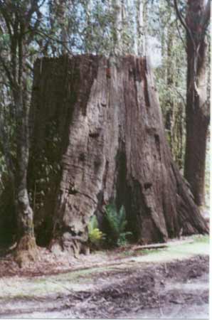
October 2001: Old massive ash stump on Callignee South Road. This area once grew some of the largest trees on the planet. Now, very few trees this size remain in the region.
Plantation Catchment:
a) Many tribs HW Flynns Creek/LaTrobe River
b) 2 HW Merrimans Creek
c) Several HW Merrimans Creek
Catchment Management Authority: West Gippsland Catchment Management Authority
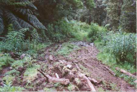
Oct 2001: Dismal roading and creek crossing on Collins Track.
"Rainforest Merrimans Creek: The section of rainforest at Merrimans Creek does not extend very far down the creek but is very wide, extending high up the slope on the eastern side. There is also a small section of old growth on the eastern edge of the rainforest. The western side of the creek was cleared for plantation purposes in late 1998 and no buffer was left for the rainforest." Rainforests in the Strzeleckis by Elaina Fraser. See also - www.hancock.forests.org.au/docs/merrimans.htm
Merriman Creek, Gormandale: The estuary contains bream, sea mullet, estuary perch, luderick and yellow-eye mullet. Flynns Creek, Flynn: A small creek with some deep pools in its middle and upper reaches. Flows through open farmland, mud and gravel bottom. Occasionally stops running in summer, lower reaches are badly silted. Contains some brown trout average 250g, maximum 650g, eels, spiny freshwater crayfish, carp, goldfish and tupong.
Source: A Guide to the Inland Angling Waters of Victoria by BR Tunbridge, PL Rogan, CA Barnham. Department Conservation and Environment. Arthur Rylah Institute for Environmental Research, 123 Brown St, Heidelberg, 3084. (4th ed - 1991).