Declared Water Catchment Area: The entire plantation lies within the Tullaroop Reservoir Catchment. Proclaimed 4/6/80. Tullaroop Reservoir (completed in 1959) supplies irrigation water to northern Victoria and domestic water to the City of Maryborough and the surrounding area including Adelaide Lead, Alma, Havelock, Majorca and Betley.
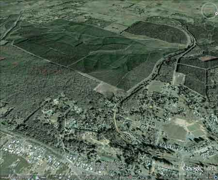
Plantation is located ~1.5km south west of the township of Creswick. Click here for map of Hancocks' Ballarat region plantations. Click here for map of North Central Water Supply Catchments This plantation was very likely to be aerially sprayed with 2,4,5-T between 1968 and 1977. The Dioxin TCDD may still exist in soil in this plantation. For more historical data on 2,4,5-T click here. For more information concerning the continuing health crisis concerning 2,4,5-T please forward to here. Water Catchment Area: LODDON RIVER CATCHMENT - POTENTIAL DRINKING WATER FOR BRIDGEWATER, DUNOLLY, INGLEWOOD, KERANG, LAANECOORIE, TARNAGULLA, MURRAY RIVER SUPPLIES WATER TO KERANG, PIANGIL, SWAN HILL, ROBINVALE, MILDURA. Herbicides Used by Hancock in Pine Plantations - Ballarat Region Victoria
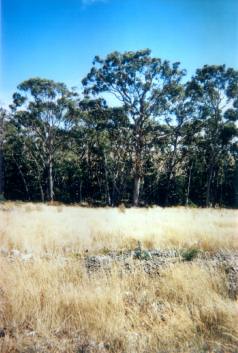
Responsible Authority: Hepburn Shire Council. (For other photos of LEGL93-40/1: Go to bottom two photos of following page).http://www.hancock.forests.org.au/docs/oct02.htm THREATENED FISH NOTES - LODDON RIVER: Tullaroop Creek is a good Blackfish water. Slaty Creek and Creswick Creek have popluations of Mountain Galaxias. The lower reaches of the Loddon also provide good habitat for Murray Cod and Yellow Belly. Plantation Catchment: Diamond Gully & Cobblers Gully flow north into Creswick Creek/Tullaroop Creek/Tullaroop Res/Loddon River.
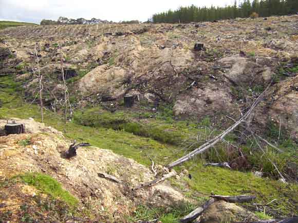
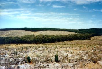
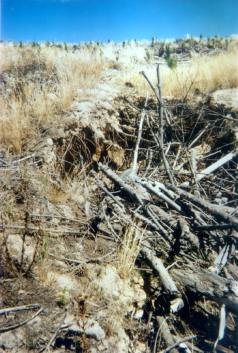
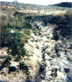
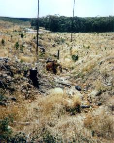
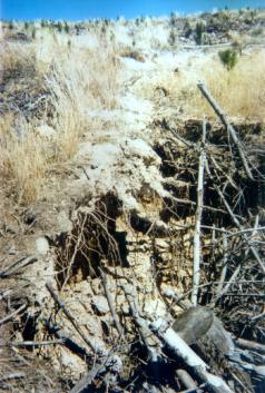
September 2002: Diamond Gully after recent logging. Note lack of buffers to protect creek from impacts of herbicides, fertilisers, sediment and disturbed mining sediment. Soils: Sourced from Geological Maps of Victoria Ocl: Ordovician (Lancefieldian): Deep marine deposits, metasandstone, grey and black slate, dominantly sand-rich turbidite facies; moderately to well sorted, variably rounded quartz with minor feldspar and lithic grains in Quartz silt or clay matrix . . . Qp: Neogene/Quaternary: Dissected colluvial, alluvial and swamp deposits; occurs in headwaters of streams disrupted by Newer Volcanics, gravel, sand, silt and clay, containing clasts of sandstone, slate and vein quartz from bedrock or granite sand from granite; generally poorly sorted and subangular; moderately to well consolidated; ferruginized in part. Catchment Managment Authority: North Central Catchment Management Authority. Ex-Gold Mining area: Gold workings occurred along Diamond Gully and Cobblers Gully in the 19th and early 20th Century. Diamond Gully was the location of the Creswick Gold Estates Hydraulic Sluicing Company. Logging could upset old mine tailings. Other notes: A Report on the Tullaroop Reservoir Catchment by the Land Conservation Council 1980 “Most streams in the catchment exhibit great variation in flow. Records show that flow in many catchment streams ceases in summer while after heavy rainfall, flood discharges of short duration occur. This pattern of flow produces a corresponding variation in water quality especially in regard to turbidity, colour and E.coli levels... The catchment to Tullaroop Reservoir lies on the northern slopes within the Western Highlands of Victoria. The catchment incorporates part of the basalt plain sloping gently towards the north, with patches of higher lands scattered along the southern and western boundaries ... Throughout the catchment, basalt of the newer volcanic series predominates. . . Ordovician sediments, the oldest material in the catchment, form the basement rock for much of the catchment. They outcrop in a large area about Creswick, in the Highlands of the south east and at several locations along the catchment boundary in the west . . . Climate within the catchment ranges from the moist cool highlands of the Great Dividing Range in the southeast. . . Soils derived from basalt material predominates throughout the catchment. These soils range from the red gradational types with fine structure found on the gentle hills in the moist southern areas . . . All the above soils are deep, with clay to clay loam textures. Excepting for the well structured soils in the south, internal drainage is very slow; consequently surface pounding across the plain is common following rain... Most of the land within the catchment has undergone development. As a result, native vegetation characteristics of the area has to a large degree disappeared, and now, is confined to the State Forest . . . Areas of softwood plantations occur about Creswick and in the south-east. Based on information given in the Land Conservation Council’s reports for the North Central and Melbourne study areas, native forests in the south and south-east would conform to an open forest II structural form with open forest III occurrinng in the more sheltered situations. Dominant species are messmate stringybark, associated with manna gum and broad leaf peppermint. . . Much of the land within the Creswick State Forest has in the past been affected by gold mining activities. Stabilisation of the worst affected areas has been achieved with softwood plantations. Additional planting of adjacent areas has followed. . . Hazards to the Water Supply Turbidity to the water supply Since the cessation of mining activities and the rehabilitation of the affected areas, the general condition of the catchment land has remained relatively stable. Under present management it is not expected that the land will have serious erosion problems endangering storage capacity. With respect to sediment and turbid runoff, the hazard it poses to the water supply will be greatest during periods of high runoff from the following areas: *the intensively cropped land in the south. *roads *eroded gully systems particularly to the south and south-east of Creswick. *to a limited extent the tailings dumps *the forested land with a high to moderate erosion hazard, during the following forestry operations until revegetation occurs...” Hancock Watch Site visit Feb 01: Drove into area from Bald Hill. Wildings problem in area of native vegetation near Bald Hill plantations. Drove under railway line - from north. Drove west and around northern and western edge of plantation. Kept to plantation boundary when road headed east. Stopped car at recent clearfelling. Saw native vegetation along Diamond Gully line for part of the plantation, however at least 1/3 of the gully was warranted with no protection whatsoever. This is a gully that eventually feeds into Creswick Creek. Saw massive erosion problems in tribs feeding into gully from west. Hancock Watch Visit Sep 02: Entered plantation from the north, drove only a short distance into recently logged and ‘prepared’ plantation area. Large portion of tributary of Creswick Creek decimated. Logging had been carried out inside creek itself (most likely pine wildings growing inside the creekline) and no buffers were apparent for a distance of several kilometres. Furthermore the soil had been ripped, including creek banks with pine logging along creek side. The entire operation was one of the worst we had witnessed. No attempt had been made by the company to improve the plantation and a mass of soil movement was apparent. A very poor operation!!! http://www.hancock.forests.org.au/docs/oct02.htm Creswick Creek: Headwater of the Birch-Tullaroop Creek system. The catchment is highly modified grazing land which was heavily mined for gold in the past. Many parts of the stream have silted up badly with once deep holes now shallow or filled. Contains redfin to 350g, some small brown trout and river blackfish. Source: A Guide to the Inland Angling Waters of Victoria by BR Tunbridge, PL Rogan, CA Barnham. Department Conservation and Environment. Arthur Rylah Institute for Environmental Research, 123 Brown St, Heidelberg, 3084. (4th ed - 1991)
|