Region: Ovens
Legal Number: LEGL/93-128/1
Plantation: Two Mile Creek
Conservation Priority: Medium/High
|
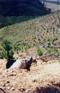
 93-128: March 01: Recent
clearfelling in the Two Mile Creek catchment. These plantations
amount to approximately 2800 hectares and surround the township
of Bright from the south and west.
93-128: March 01: Recent
clearfelling in the Two Mile Creek catchment. These plantations
amount to approximately 2800 hectares and surround the township
of Bright from the south and west. |
|
Plantation within Australian Newsprint Mill (ANM) Ltd area of supply.
Plantation within Carter Holt Harvey (now owned by International
Paper) area of supply.
Plantation within Dominance Industries (Alpine MDF Industries) area
of supply.
Plantation within D & R Henderson/Monsbent area of supply.
North East Victoria Plantation
Map here
Plantation in very close proximity to Bright. Source: Melbourne
University School of Resource Management Land & Food Resources.
This plantation was very likely to be aerially
sprayed with 2,4,5-T between 1968 and 1977. The Dioxin TCDD may still
exist in soil in this plantation. For more historical data on 2,4,5-T
click
here. For more information concerning the
continuing health crisis concerning 2,4,5-T please forward to
here.
Herbicides Used by Hancock
in Pine Plantations - North East Region Victoria
| Herbicide |
Label Rate max as kg/ha |
Used to control |
Notes |
Application |
| Carfentrazone-Ethyl |
0.036 |
|
|
|
| Clopyralid |
2.55 |
Woody Weeds |
Highly Toxic/Potential Ground water Contaminant |
air or ground |
| Glyphosate |
3.6 |
Herbaceous and woody weeds, noxious weeds |
|
|
| Hexazinone |
4 |
Woody Weeds |
Ground Water Contaminant |
Aerial, ground, spot |
| Metsulfuron-Methyl |
0.06 |
Woody Weeds, Noxious Weeds |
Potential Ground Water Contaminant |
Aerial, ground or spot |
| Triclopyr |
3 |
Woody and Noxious Weeds |
|
Ground, spot, basal bark |
Proclaimed Water Catchment Area: This
plantation area is located in the Ovens River (Wangaratta) Water Supply
Catchment.
MURRAY RIVER SUPPLIES WATER TO YARRAWONGA, COBRAM, BARMAH, ECHUCA ,
KERANG, PIANGIL, SWAN HILL, ROBINVALE, MILDURA
THREATENED FISH NOTES - OVENS RIVER: Most important river in
Victoria in regard to the survival of the Murray
Cod. Murray
Cod spawn almost as far up as Myrtleford
and the Ovens supplies recruitment for the Murray River as well. The
Ovens has no dams and is a river of extreme national significance. Trout
Cod are now being found in the Ovens
and may set up a self sustaining spawning population. Trout
Cod have been successfully stocked into
Ovens and upper Ovens, downstream of Myrtleford and going up the King
River - past Moyhu. All the tribs of the Ovens are important for native
fish including King, Buffalo and Buckland Rivers.
Responsible Authority: Alpine Shire Council
Plantation Catchment: Headwaters and tributaries of Deep Creek/Ovens
River. Headwaters and tributaries Stackey Gully/Ovens River. Headwaters
and many Tributaries of Two Mile Creek/Buckland River/Ovens River.
Catchment Managment Authority: North East Catchment Management
Authority
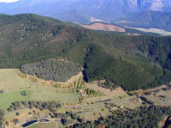
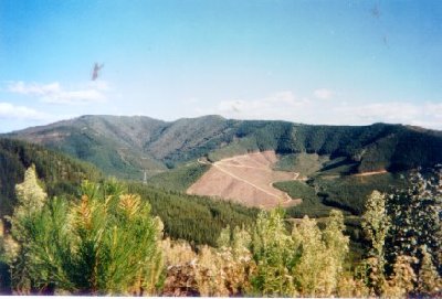
LEGL93-128 - looking southwest
from Apex Lookout and the township of Bright in the foreground. This
photo shows a portion of this plantation which is 2800 hectares in size.
Gully running south of plantation likely to be Stackey Gully.
Hancock Watch site visit Mar 01: Massive plantation. Drove into
north west section of plantation. Much of the most sustainably questionable
logging that took place was occurring on steep slopes - probably too
steep to be sustainable. As is the case with plantations in a similiar
bind is that steep slopes can also create erosion problems for roads
and culverts. Saw a couple of new culverts being built into the roadsides
and a couple of culvert blowouts. Plantations situated on flatter land
were generally not so much of a problem. Because of the immense size
of this plantation and the poor quality maps exact locations were difficult
to determine. On southern boundary saw some evidence of pine infestation
into surrounding bushland. Blackberry infestation evident along some
creeklines, erosion problems from new roads also apparent. Some roading
appeared to be on very steep slopes causing unwarranted erosion potential.
03: When we revisited the plantation almost
two years later it was evident that very little further logging had
taken place in this plantation.
�Special Investigation: North-Eastern Victoria - Ovens Softwood Plantation
Zone. Land Conservation Council 1981.
p11 Central Region To the north and east of the Eastern Boundary Fault
lies an extensive area of mountainous terrain composed of Ordovician
sandstones and mudstones that are less resistant to erosion than the
rocks of the south-western region. The drainage pattern is dendritic
and the streams are seperated by sharp ridges and spurs. The mountains
to the south of Mount Buffalo are typical of this region, which extends
east to Mount Beauty and north to Myrtleford. In the north-west around
Moyhu and Bobinalwarral the ridges of Ordovician sediments become buried
beneath the alluvial deposits of the riverine plain. Within the region,
exposures of granitic rocks have intruded into the surrounding Ordovician
sediments. Intense heat associated with the intrusions has altered (or
metamorphosed) the adjacent sedimentary rocks.
The granite outcrops at Mount Buffalo and Mount Emu are extremely resistant,
while the surrounding sedimentary rocks which are less resistant have
been deeply dissected. In contrast, the granite in the Pinnacles area
to the east of Myrtleford is more susceptible to weathering and erosion
and as a consequence the terrain in this area is more subdued. A ridge
of metamorphic rocks borders Happy Valley to the east of Myrtleford.
Friable reddish and brownish gradational soils occur on the Ordovician
sediments of this region, while the granitic rocks of Buffalo Plateau
and Mount Emu exhibit a variety of soil types. Stony loams are characteristic
of rocky outcrops while poorly drained sites contain organic loams and
peats. Sandy loams and friable gradational soils are found on the lower
slopes of these intrusions. The less resistant granitic rocks at the
Pinnacles and Abbeyard carry a variety of gradational soils on the upper
slopes and a range of duplex soils at lower elevations. The gradational
soils are suitable for softwoods, but the poorly drained duplex soils
are not.
Ovens River: The rivers all flow north, from heavily forested
mountain country through excessive river flats to the Murray River.
Murray cod populations close to the Murray River. Small river blackfish
are common in many rivers, Macquarie Perch are still occasionally caught,
and catches of golden perch are also being reported. Brown trout widely
distributed through system with rainbow trout most abundant in upper
reaches. Upstream from Myrtleford - Brown Trout to 1.3kg, some rainbow
trout, small redfin and river blackfish.
Ovens River: Upstream from Myrtleford - Brown Trout to 1.3kg,
some rainbow trout, small redfin and river blackfish.
Buckland River, Porepunkah: Flows through forested country,
gravel and rock bed. Lower reaches are badly silted and erosion, siltation,
gravel and water extraction have reduced the available fish habitat.
Joins the Ovens River near Porepunkah. Catchment has been extensively
mined for gold. Area around Buckland Junction and downstream has been
greatly modified by widespread mining and gold dredging. Contains mostly
brown trout in the headwaters, average 230g, better fish between 450g
and 750g in the lower reaches, average 350g with occasional fish to
2kg, some small rainbow trout to 300g, river blackfish to 160g, and
small redfin in the lower reaches. Also abundant sping freshwater crayfish.
Popular trout fishing.
Source: A Guide to the Inland Angling Waters of Victoria by BR Tunbridge,
PL Rogan, CA Barnham. Department Conservation and Environment. Arthur
Rylah Institute for Environmental Research, 123 Brown St, Heidelberg,
3084. (4th ed - 1991)
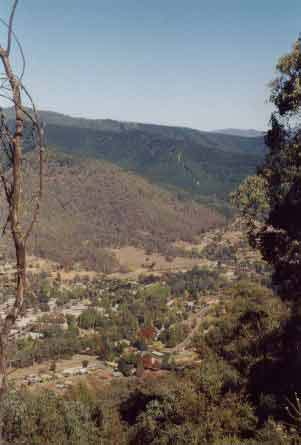
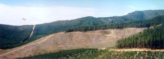
 93-128 March 01: Milder
slopes with Mount Buffalo in background. Looking west.
93-128 March 01: Milder
slopes with Mount Buffalo in background. Looking west. |
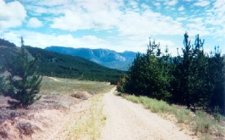
 93-128 March 01: Recent
pine establishment. Note erosion potential. Shot taken from Snake
Ridge Road.
93-128 March 01: Recent
pine establishment. Note erosion potential. Shot taken from Snake
Ridge Road. |
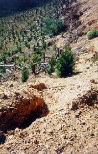
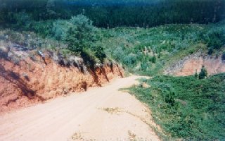
 93-128 March 01: Recent
culverting and drainage works. Will this minimise erosion? Shot
taken from Snake Ridge Road. Some erosion of this road was observed
in a follow up visit in April 03.
93-128 March 01: Recent
culverting and drainage works. Will this minimise erosion? Shot
taken from Snake Ridge Road. Some erosion of this road was observed
in a follow up visit in April 03. |
 93-128 March 01: View looking
south into recent plantation cut. Probably Victoria's highest elevation
plantations at about 800 metres. Eagle Peak - the highest point
in the photo is 1017m. Also note the pine wildlings in the native
vegetation running up the gully to Eagle Peak.
93-128 March 01: View looking
south into recent plantation cut. Probably Victoria's highest elevation
plantations at about 800 metres. Eagle Peak - the highest point
in the photo is 1017m. Also note the pine wildlings in the native
vegetation running up the gully to Eagle Peak. |
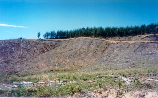
 93-128 March 01: More clearfell
logging in the Two Mile Creek catchment.
93-128 March 01: More clearfell
logging in the Two Mile Creek catchment. |
 93-128 March 01: No gully
protection or buffers.
93-128 March 01: No gully
protection or buffers. |
 93-128 March 01: Blackberry
infestation of gully that eventually drains into Two Mile Creek
which inturn drains into the Buckland River..
93-128 March 01: Blackberry
infestation of gully that eventually drains into Two Mile Creek
which inturn drains into the Buckland River.. |
HOME
|