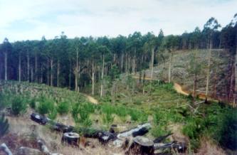
Plantation within AKD Softwoods area of supply. Plantation within SPE Exports (Geelong) area of supply.
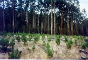
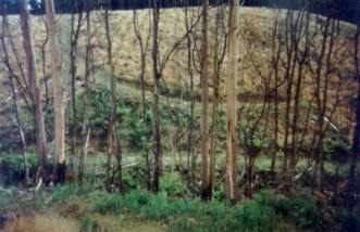
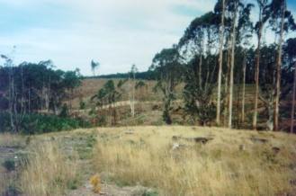
Webster Hill Plantation circa 2005. This plantation was very likely to be aerially sprayed with 2,4,5-T between 1968 and 1977. The Dioxin TCDD may still exist in soil in this plantation. For more historical data on 2,4,5-T click here. For more information concerning the continuing health crisis concerning 2,4,5-T please forward to here. Plantation where the Secretary CNR retains specified rights to harvest hardwood sawlogs. Water Catchment Area: GELLIBRAND RIVER CATCHMENT. LAND USE DETERMINATION (LUD) 24/8/83. (LUD’s replaced by Special Area Plans under the Catchment and Land Protection Act 1994). Water supply for the Gellibrand River is a South West Water responsibility. Lardners Creek which takes in the western side of this plantation is water supply catchment for the township of Gellibrand. Water supply for Lardners Creek is a Barwon Water Responsibility.
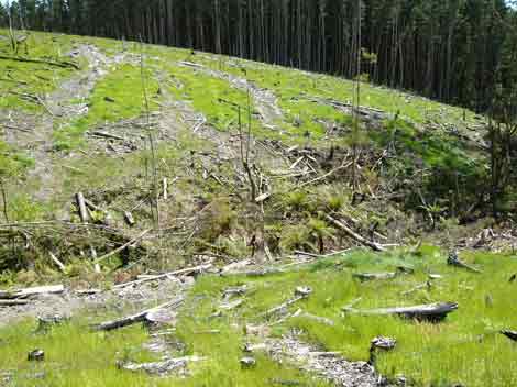
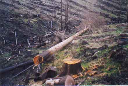
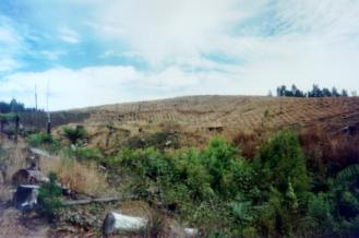
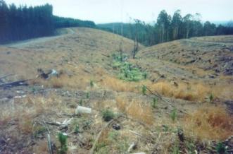
November 2004: Photo taken
several months after logging. Note lack of buffers on tributary of Lardners
Creek East Branch. Note emergence of grasses which will most likely
be aerially sprayed. Is this a sustainable practice in a proclaimed
water supply catchment? LARDNERS CREEK CATCHMENT - POTENTIAL DRINKING WATER FOR GELLIBRAND. Land System: Plateaux on crests of ranges (Beech Forest). Beech Forest land system: Along the crest of the wettest part of the Otway Range lies a rolling plain with rounded hills and shallow valleys. This area has one of the highest annual rainfalls in Victoria, averaging almost 2000mm at Weeaproinah. Prior to settlement late last century, tall open forests, E.regnans and associated species dominated the landscape, but now most areas have been cleared for agriculture...The perennial nature of many of the creeks and drainage lines gives the area high water catchment values. Conflict also arises between its scenic appeal as a rural landscape and the conversion of farmland to softwood plantations”. Geology: Lower Cretaceous sandstone, mudstone. Landscape: Rolling Hills Soils: Brown gradational soils. Forms of soil deterioration: Nutrient decline, surface compaction, sheet and landslip erosion. Known landslide area on Lardner Track. Herbicides Used by Hancock in Pine Plantations - Ballarat Region Victoria
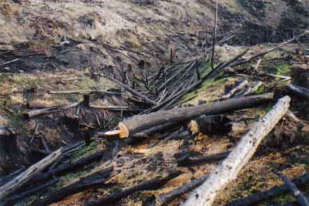
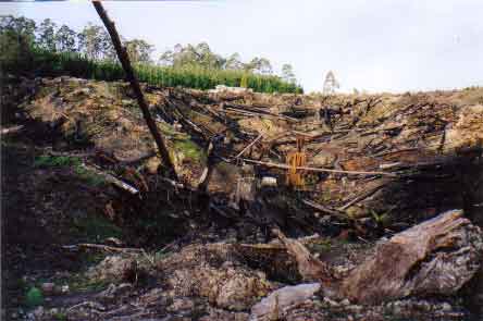
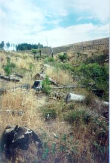
June 2002: Torched tributary
of Lardners Creek East Branch. Is this world's best practice in a Proclaimed
water supply catchment. Is Barwon Water monitoring this site? Note chainsawed
remnant trees. For more photos highlighting unsustainable logging practices in this plantation go to bottom 7 photos from the following link: http://www.hancock.forests.org.au/docs/logging_practices_7-02_updates.htm http://www.hancock.forests.org.au/docs/may02b.html#content_top Quote of the year 2002: "Colac Otway Shire 6/12/02. Freedom of Information Request. In response to your request for information relating to the use of herbicides by plantation companies, I advise that there are no records within Council, as plantation companies are not yet required to advise either Council or the Department of Natural Resources and Environment of their intention to conduct herbicide applications. Yours sincerely - Freedom of Information Officer - Colac Otway Shire". Plantation Catchment: Several major creeks flowing into Asplin
Creek/Gellibrand River.
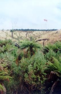
June 2002: Chainsawed non plantation tree in buffer zone of Lardners Creek East Branch. Also see November 2004 Logging Updates
Page ‘A report on the Gellibrand River (South Otway) Catchment - Soil Conservation Authority 1979’. “p1 The Gellibrand River is an extremely important source of domestic water for the south of the western district. . . p2 Over the drier months the Carlisle River - Camperdown Otway main pipeline is unable to meet peak demand for water supply in Warrnambool, and this led to the Water Commission installing the South Otway system. The South Otway pumps and pipeline provide 13/ML/day through the drier months of the year, flow in the Gellibrand River at the pump station for the months of December to March averaging 183 ML/day . . . p8 The combination of high rainfall and steeply dissected slopes in the Otway Ranges suggest high potential hazards of soil erosion and water supply degradation. Any operation involving soil disturbance is likely to cause short-term quality deterioration, and possibly longer term problems. The high rainfall produces good growing conditions, but major soil losses can occur before natural regeneration stabilises a disturbed area, and an active revegetation program is preferable. . .” “p10 Harvesting of Mountain Ash necessitates clearfelling, followed by managed re-establishment. During logging the following changes occur: a change in the hydrological balance of rainfall, vegetation, and soil; removal of the protective litter on the surface; disturbance of soil along roads, tracks, snig tracks, and log landings; and hard-surfacing of access roads and tracks. Together these cause increases in surface runoff and sheet and rill erosion, resulting in colloidal material and sediment in run off . . . Private pine planting operations . . . are accompanied by similar potential water supply hazards to hardwood forestry. However because of the shorter rotation, management operations are more frequent. . .” ‘Report on a proposed land use determination for the Gellibrand River Catchment - Soil Conservation Authroity 1983’ “p2 Most of the water from the Gellibrand River Catchment which is used for water supply, is taken directly from the river or its tributaries at pump or gravity offtake. Apart from the case of the Colac Waterworks Trust Reservoirs, there is no significant water detention to allow settlement of suspended solids, clarification and self-purification over time. The quality of water taken into the water supply pipeline is therefore the raw quality of the river flow. The quality of the river water is in turn responsive to events in the catchment. High peak flows associated with heavy storms may initiate streambank erosion; any earth disturbance in the catchment may cause deterioration in runoff water quality due to increases in turbidity and suspended sediment. There are a number of land uses and management practices occurring in the catchment which necessitate earth disturbance and which may cause erosion. These include land clearing, road construction, hardwood and softwood operations, extractive industries and some farming activities...” “p57 The lower cretaceous sediments in the Otways are known for their relatively high landslide hazard. Factors considered area prone to landsliding include; *the presence of a previous slope failure *high annual rainfall *moderate to steep slopes *suitable lithogies *deep weathering *favourably orientated discontinuties” p59 Diversion of drainage water onto steep slopes, for example from road culverts and cutoff drains, can also exacerbate potentially unstable slopes. Slumps, mainly in the surface soil material, are more common than large-scale rock and soil landslides. Slumps may occur in fill material, on steep cut slopes or on hillsides after heavy rain or removal of vegetation. Where such earth movements occur close to drainage lines, they can be a major source of turbidity and sediment. Most of the landslides ... occur in the AIRE land system and on freehold land which had been cleared. This includes an area on Lardner Track, now the Webster Hill softwood plantation. While Cooney noted that dense tree cover probably obscured many landslides in parts of his study area, there is still an apparent link demonstrated between land clearing and landslides. The large landslides which have occurred in the catchment can be considered dormant. On the other hand, quite a few of the small landslides are active. Cooney noticed a very strong tendency for small landslides to occur in previously failed materials, that is, within prior large landslides.” p100 “. . . These existing and proposed plantations are located mainly on slopes of the AIRE land system, where the management problems of agriculture allow relatively cheap land purchase. Plantations have been established on both previously cleared pasture land and on blocks which had been under hardwood timber. The cleared land was often run-down, having blackberries in the drainage lines. The standing timber on the forested blocks was usually on steep slopes. . . p101 Plantations have also been established on the deep soils and gentle slopes of the BEECH FOREST land system. However, the manager of one company believes that pines grown in such high rainfall areas grow too fast, are too light, and have a grain too coarse for structural use of the timber. Cases of toppling and multiple leaders have been observed in some Pinus radiata plantations on exposed sites on the Otways ridge and slopes. These problems are thought to be associated with the high rainfall conditions, and the high levels of residual nitrogen and phosphorus on sites previously used for agriculture (Flinn D.W., 1982, pers. comm.). . . Some plantation establishment has been attempted on the grey sand soils, with very poor results, particularly where there are hardpans in the soil profile...”
June 2002: Bulldozed and totally trashed tributary of Lardners Creek East Branch. Is this any way to treat a catchment that supplies drinking water for people? A study of the Land in the catchments of the Otway Range and Adjacent Plains - Soil Conservation Authority 1981. p143 Both establishment and harvesting of hardwood and softwood forests cause serious changes to the natural hydrological balance. Pine establishment on disused agricultural land and previously forested land has led to widespread deterioration. The steep north and west facing slopes of Lorne, Forrest, Moggs Creek, Aire, Mt Mackenzie, Bunker Hill and Yahoo Creek land systems are the most severely affected. Sheet erosion losses can be minimised by working in coupes along the contour, and by maintaining adequate vegetative cover with litter layers over the soil surface. The incidence of landslips increases following harvesting, when the binding effect of tree roots is removed and the soil is subject to saturation for longer periods. The study area share the current trend to reduce the total area of productive forest land and manage this smaller area for higher yields. As with agriculture, nutrients removed in forest produce need to be replaced through the use of fertilisers. The fertiliser requirements of soils designated for long-term hardwood and softwood production require investigation. p142 Steep slopes in and around drainage lines are more stable under
hardwood than softwood forestry, because of longer growth period and
more selective logging practices.
More Pictures |