Traralgon Creek erosion hotspot
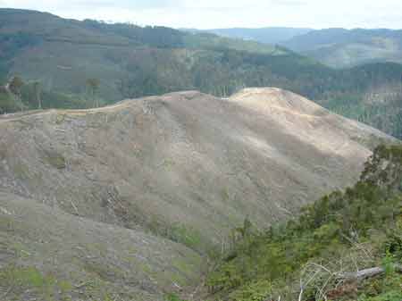
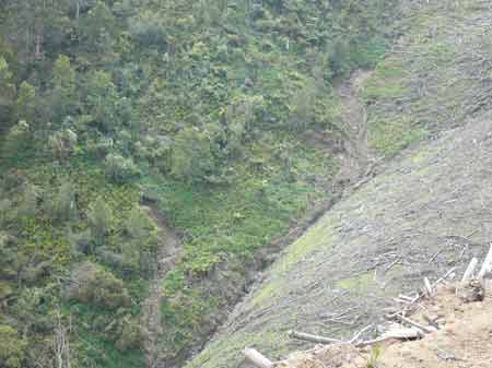
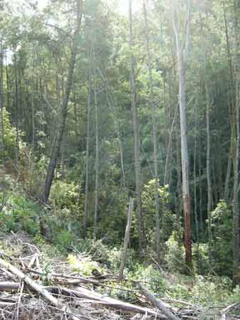
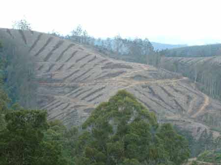
October 2007: Strzelecki Ranges - Traralgon Creek Catchment - Parish of Callignee. If you clearfell a hundred or so hectares of pine on slopes such as this then you are playing with fire, especially if heavy rain follows logging. The ridge in this image is between 400m and 340m in height. The creek at the bottom of this image lies about 130m-140m below the ridge line, with nothing holding the soil. Soils are the highly erodable cretaceous sediments.
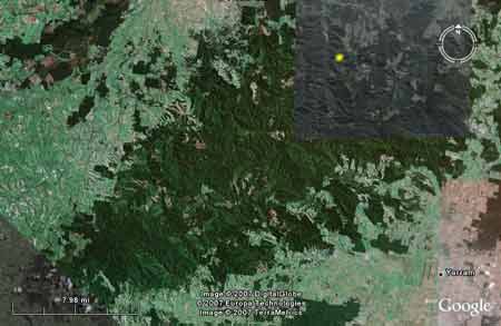
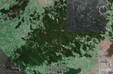
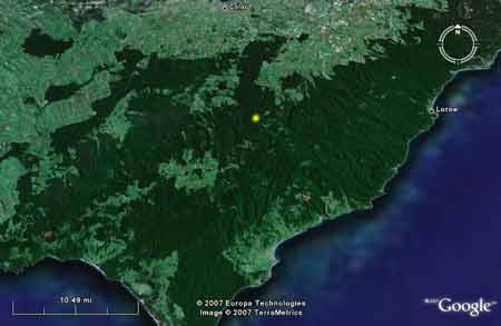
Strzelecki Ranges: Yellow mark indicates location of these plantations.
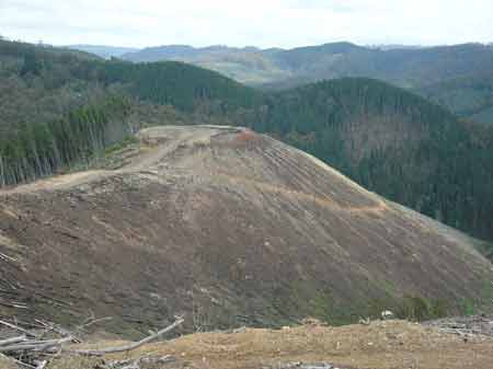
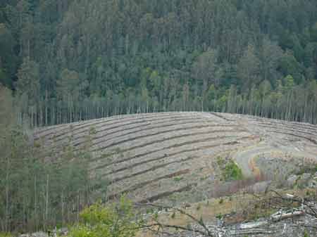
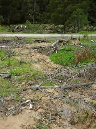
October 2007: Strzelecki Ranges - Traralgon Creek Catchment - Parish of Callignee. The log landing at the top of this peak is 340 m high. On its western edge the drop is 160m to the creekline below. This pine coupe is certified by the Forest Stewardship Council.
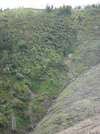
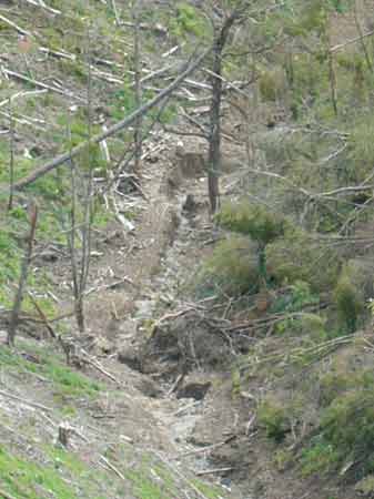
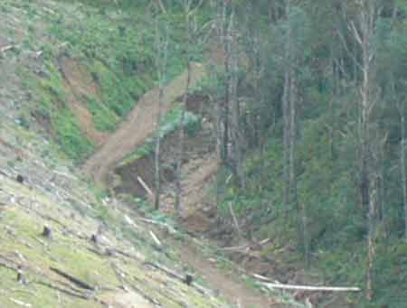
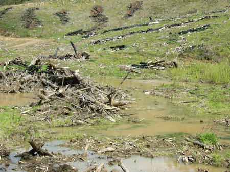
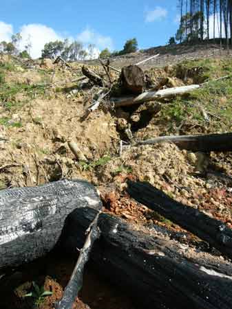
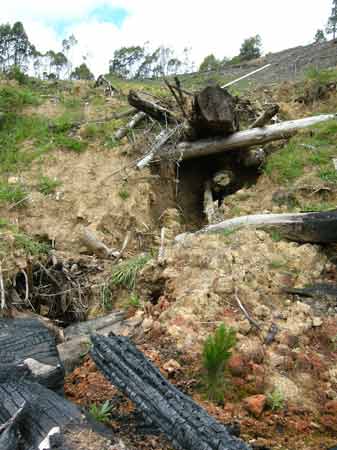
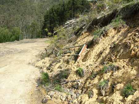
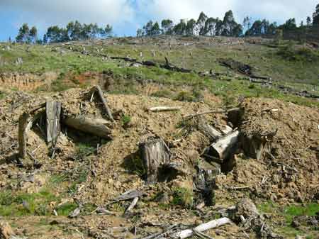
October 2007: Strzelecki Ranges - Traralgon Creek Catchment - Parish of Callignee. Head of gully, with landslips forming. The slope in this image is 150m high, meaning that the landslip is close to 80m in height. The landslip has caused scouring of the gullyline for about 1km.
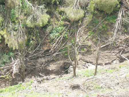
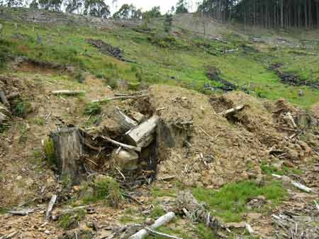
October 2007: Strzelecki Ranges - Traralgon Creek Catchment - Parish of Callignee. Closer shot of erosion of gully head after pine logging.
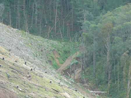
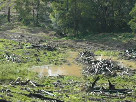
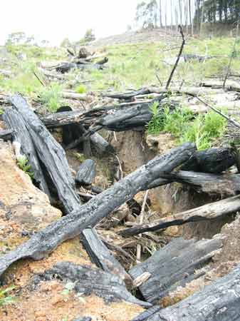
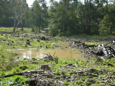
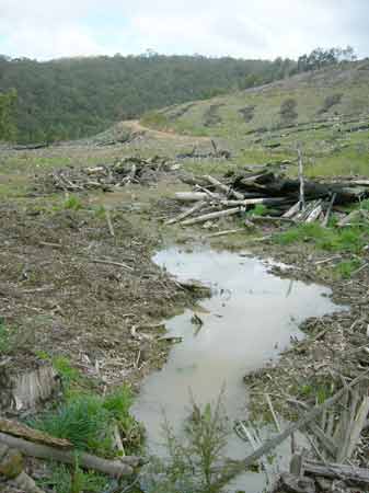
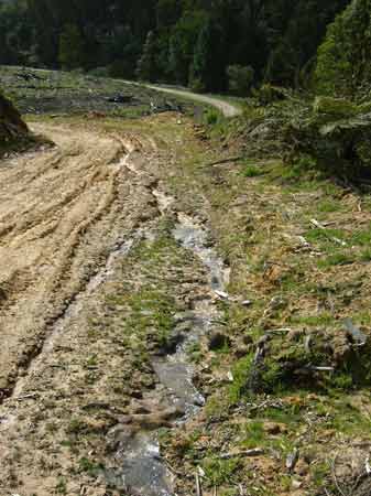
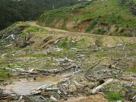
October 2007: Strzelecki Ranges - Traralgon Creek Catchment - Parish of Callignee. Scouring of tributary of Traralgon Creek. The scouring is at some points several metres deep, meaning that over the length of the gully, hundreds, if not thousands of tonnes of sediment have been washed away. Traralgon Creek flows into the Latrobe River, which in turn flows into the Gippsland Lakes, meaning that much of the soil eroded from this site will eventually make its way into the Gippsland Lakes. A sustainable plantation outcome?
October 2007: Strzelecki Ranges - Traralgon Creek Catchment - Parish of Callignee. Another view of the scoured drainage line. This is probably irrepairable.
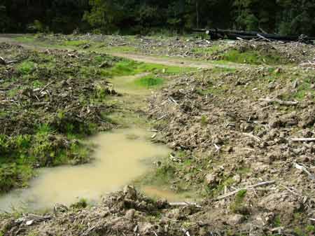
October 2007: Strzelecki Ranges - Traralgon Creek Catchment - Parish of Callignee. The erosion at this point, caused by this FSC certified pine plantation is several metres high and has threatened this logging road from being washed away. What happened to the theory that plantations actually protect soils from erosion and improve water quality?
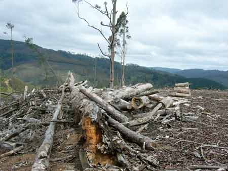
October 2007: Strzelecki Ranges - Traralgon Creek Catchment - Parish of Callignee. Pines weren't the only trees cut down at this site. Bluegums have also been removed. Were permits granted by Latrobe Shire for the removal of native vegetation by Hancock?
October 2007: Strzelecki Ranges - Stony Creek/Jack River Catchment. This catchment flows into the Nooramunga marine reserve. Approximately 8000 hectares of pine will be logged in the Nooramunga catchment over the next decade. What impact will this logging have on the water quality of catchments feeding into Nooramunga?
October 2007: Strzelecki Ranges - Macks Creek Catchment - Roberts Road. This road will be widened to take the thousands of truck journeys required over the next decade to cart 8000 hectares of Hancock's plantations to the Latrobe Valley.What rights do people have who live on this road, who will have their lives severely impacted by the truck movements? At this particular point the road passes through the extremely rare Strzelecki Warm Temperate Rainforest.
October 2007: Strzelecki Ranges - Jack River Catchment, near Yarram Madalya Road. FSC certified pine logging in very close proximity to a stand of warm temperate/cool temperate rainforest overlap. Hancock's policy is to leave no rainforest buffers on Warm Temperate Rainforest, despite experts advising to leave substantial buffers. Pines are likely to be replanted into this buffer. FSC certification has provided no guideance on protecting warm temperate rainforest.
Strzelecki Ranges: Yellow mark indicates location of this Jack River warm temperate rainforest.
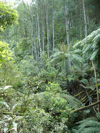
October 2007: Strzelecki Ranges - Jack River Catchment, near Yarram Madalya Road. Cool temperate rainforest species growing in close vicinity to warm temperate rainforest species. Likely to be very rare overlap rainforest.
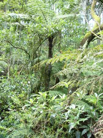
October 2007: Strzelecki Ranges - Jack River Catchment, near Yarram Madalya Road. Slender Tree Fern (cool temperate rainforest indicator species) growing in area identified as being Warm Temperate Rainforest. The site is about 20 hectares in size and Hancock has afforded the site no buffers.

October 2007: Strzelecki Ranges - Jack River Catchment, near Yarram Madalya Road. Muttonwood, a warm temperate rainforest species.
October 2007: Strzelecki Ranges - Smiths Creek Catchment. In this catchment Hancock have afforded the cool temperate rainforest buffers of only 20 metres. Despite this, the company has retained its FSC certification.

Strzelecki Ranges: Yellow mark indicates location of Smiths Creek.
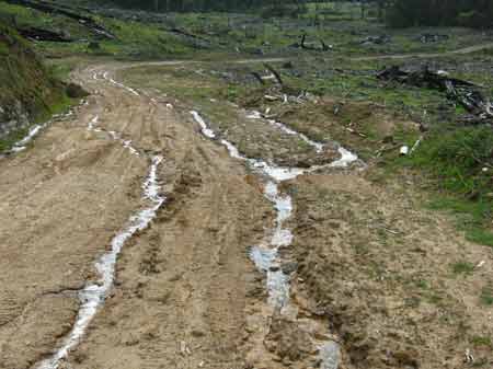
October 2007: Strzelecki Ranges - Smiths Creek. Contour ploughing has been adopted by Hancock as a way of retaining most rainfall on site. This denies streams much needed environmental flows, as the contour ploughing acts as a dam, allowing very little water to percolate downstream.
October 2007: Strzelecki Ranges - Middle Creek Catchment. Warm temperate rainforest species emerging in the understorey of this very poorly maintained pine plantation. The rainforest species are likely to be destroyed when the pine logging occurs.
October 2007: Strzelecki Ranges - Middle Creek Catchment. Weeds, such as Willows dominate this catchment, which Hancock own the leases for.
Breaches include: Section 4.2.1 Mandatory Action - Waterways, Section 4.4.2 Mandatory Actions - Road Design, Section 4.4.3 Mandatory Action - Road Construction, Section 4.4.4 Mandatory Action - Road Maintenance
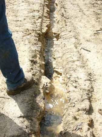
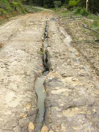
*There is no or very little drainage along the road that has resulted in considerable erosion of the track, in some places, down to bedrock
*There is only one culvert/discharge point away from the road for a length of approximately 800m.
*There is evidence of batter's slumping, causing further erosion.
*There is some evidence of machinery driving through drainage lines (rather than constructing a culvert crossing)
Legal action to proceed if site is not remediated to satisfaction of Council.
For details of remedial work see here
October 2007 - Otway Ranges - Gellibrand River Catchment. Stevensons Falls Plantation. Not a good look in a domestic water supply.
A Forestry company has been reprimanded for causing serious erosion in the Otway Ranges.
Hancock Victorian Plantations (HVP) was found to have breached the code of practice for timber production because it failed to install adequate drainage along a track in Barramunga. The pine plantation, on Sayers Track, is within the Gellibrand River catchment, where much of Warrnambool's water comes from.
The erosion had allowed sediment to flow into the river system, according to Friends of the Earth land use researcher Anthony Amis who reported the breaches.
Colac Otway Shire said there was little or no drainage along parts of Sayers Track, causing erosion down to the bedrock.
Only one culvert or discharge point had been installed to take water away from a section of road which was about 800 metres long, the shire told HVP.
There was also evidence of machinery being driven through drainage lines instead of building a crossing over the drains.
Colac Otway Shire's general manager of sustainable planning and development Jack Green said the council had requested the site be repaired by November 23. Mr Green said that if the council was not satisfied with the company's effort to repair the track on time, legal action would be taken, he said.
HVP environmental services manager Malcolm Tomkin said he was unsure why the drains had not been built. "It's our normal procedure to drain our roads correctly," he said.
"We've got a period of time to improve the drainage on the track."
Colac Otway Shire Council has threatened Hancock Victorian Plantations Pty Ltd with legal action for a series of violations.
Shire's environmental planner Heidi Robinson has notified Hancock it breached codes relating to waterways management and road design, construction and maintenance at 350 Sayers Track, Barramunga.
The company has until November 23 to rectify the damage or risk the council taking legal action.
Land use researcher with Friends of the Earth alerted the shire to be breaches.
The environmental group said the breaches contributed to the degradation of the water quality in waterways in the area through increases in sedimentation of waterways from logging.
Researcher Anthony Amis said Friends of the Earth had concerns about the plantation's operations at the Stevensons Falls site and directed its concerns to Colac Otway Shire Council.
Mr Amis said the group was encouraged the shire had taken the action.
"It's good to see local government taking a proactive stance relating to the code of practice," Mr Amis said.
'Even if they do improve it a alot of damage has been done," he said.
Mr Amis said Friends of the Earth had also monitored the operations of timber plantation company Midway in the Otways downstream from Stevensons Falls and had reported similar alleged breaches.
Hancock Victorian Plantations has 164,000 hectares of timber plantations in Victoria and harvests three million tonnes of timber annually for domestic use.
The company's environmental services manager Malcolm Tonkin said the company processes had failed and the shire was correct to ask to have the situation addressed.
"In this instance we haven't got it right. When conditions are right we'll out there to rectify the situation," Mr Tonkin said.
October 2007 - Otway Ranges - Gellibrand River Catchment. Stevensons Falls Plantation. Turbid run off from extremely poorly formed logging roads have sent sediment tainted water into the Gellibrand River at this site. The roads and drainage at the site most likely breach the Code of Forest Practice. The site has recently been visited by the Colac Otway Shire.
Yellow dot marks location of Stevensons Falls plantations in the Otways. Gellibrand River map can be found here.
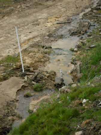
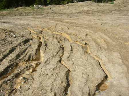
October 2007 - Otway Ranges - Gellibrand River Catchment. Stevensons Falls Plantation. FSC certified roading drainage in a plantation that lies in a catchment that supplies 50,000 people with drinking water. Water can be seen clearly in this image. The site recorded about 30mm of rain the day before these images were taken.
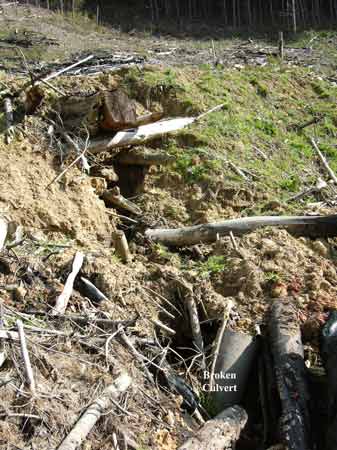
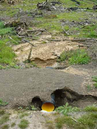
October 2007 - Otway Ranges - Gellibrand River Catchment. Stevensons Falls Plantation. This is the site of where a culvert has either washed out or has been deliberately broken. The culvert has been replaced with a log, which in turn has caused a scouring of the drianage line. All of this has occurred with FSC's apparent blessings. FSC operations are only audited once a year (over a week period) meaning that the vast majority logging coupes are not audited at all.
November 2007: Where the culvert should be instead of a log. Has Hancock really sacked their culvert maintenance staff?
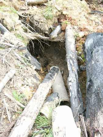
Nov 07: Same culvert three weeks later
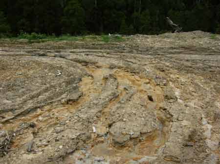
October 2007 - Otway Ranges - Gellibrand River Catchment. Stevensons Falls Plantation. The scouring of the drainage line just below this point is over a metre deep.
Nov 07: same place three weeks later.
November 2007: Note erosion caused by having no culvert. Several metres deep at this location.
October 2007 - Otway Ranges - Gellibrand River Catchment. Stevensons Falls Plantation. FSC certified road drainage in a domestic water supply. Clear breaches of the Code of Forest Practice. What will Colac Otway Shire do?
October 2007 - Otway Ranges - Gellibrand River Catchment. Stevensons Falls Plantation. Sediment tainted water draining off the plantation straight into the Gellibrand River.
October 2007 - Otway Ranges - Gellibrand River Catchment. Stevensons Falls Plantation. FSC certified road batters, which have eroded away to the point that the gate in this image has fallen over.
October 2007 - Otway Ranges - Gellibrand River Catchment. Stevensons Falls Plantation. Back up of turbid water washed down from poorly maintained logging road. This water is ready to wash into the Gellibrand River.
Another dodgy drianage line.
October 2007 - Otway Ranges - Gellibrand River Catchment. Stevensons Falls Plantation. Poor road drainage has led to this logging road being gouged away by water. The sediment washed off this road will eventually be deposited in the Gellibrand River. In places the road has been washed out to reveal bedrock.
November 2007: Same place three week later.
Water moving down the logging road.
November 2007: Three weeks later
ditto
October 2007 - Otway Ranges - Gellibrand River Catchment. Stevensons Falls Plantation. Extremely poorly maintained logging roads, some of the worst that Hancock Watch has witnessed.
Nov 07: three weeks later
Nov 07: Note amount of road that is being washed closer to Gellibrand River.
November 2007: Erosion leaving Hancock site into ana-branch of Gellibrand River.
November 2007: FSC certified roading drainage
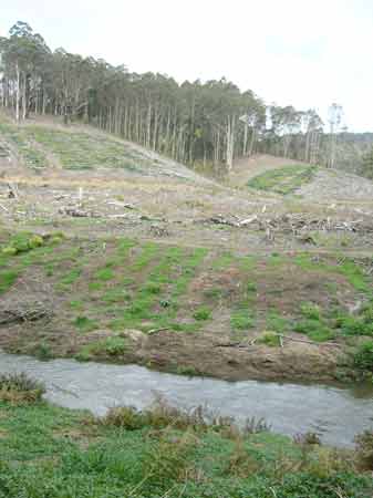
October 2007 - Otway Ranges - Gellibrand River Catchment. Stevensons Falls Plantation. Gellibrand River going through willow removal and pine logging. What happens when the plantation is sprayed with herbicides?