Region: OvensLegal Number: LEGL/93-149Plantation: Hurdle CreekConservation Priority: HighPlantation within Australian Newsprint Mill (ANM) Ltd area of supply. Plantation within Carter Holt Harvey (now owned by International Paper) area of supply. Plantation within Dominance Industries (Alpine MDF Industries) area of supply. Plantation within D & R Henderson/Monsbent area of supply. Proclaimed Water Catchment Area: This plantation area is located in the Ovens River (Wangaratta) Water Supply Catchment. North East Victoria Plantation Map here
April 2003: Headwaters of Clear Creek - Recently clearfelled with minimal protection of natural drainage lines. For more graphic photos of this plantation go to: April03 Ovens Updates. KING RIVER CATCHMENT SUPPLIES WATER TO MOYHU, OXLEY. MURRAY RIVER SUPPLIES WATER TO YARRAWONGA, COBRAM, BARMAH, ECHUCA , KERANG, PIANGIL, SWAN HILL, ROBINVALE, MILDURA. Incomplete Herbicide Regime This plantation was aerially sprayed with 2,4,5-T between 1968 and 1977. The Dioxin TCDD may still exist in soil in this plantation. For more historical data on 2,4,5-T click here. For more information concerning the continuing health crisis concerning 2,4,5-T please forward to here. "In June 1973 the F.C.V. (Forests Commission Victoria) carried out a larger study in 1 335 hectare section of a pine plantation in a catchment of Clear Creek near Myrtleford. Four stream sample points were established at varying distances from the spray area and a total of 1,000 samples were collected over a ten day period. Major peaks in 2,4,5-T concentration occurred after rain, and lesser, relatively insignificant, peaks also occurred during spraying (McKimm, 1974). McKimm stated that 2,4,5-T concentrations were in excess of the upper limit of 20 ug/litre set by the N.H. & M.R.C. but he did not list values. In fact, at the sampling point immediately below the spray zone values of 75 ug/l were obtained during spraying and peaks up to 690ug/l were obtained after rain. Three kilometres downstream values of 135 ug/l were obtained during spraying and peaks up to 500ug/l were obtained after rain. Worse, for the sampling point immediately below the spray zone, of 83 readings made during the seven days after spraying, 48% (40) exceeded 20 ug/l.; 14% (12) exceeded 50 ug/l.; and 7% (6) exceeded 100 ug/l. These measurements indicated that there was a significant threat to streams in aerially sprayed areas, but nothing was done. Rather, two new monitoring programs were organised, one at Carboor near Myrtleford and another at Narbethong in the Central Highlands." (Source: The Herbicide 2,4,5-T and its use in Forestry. By Peter Rawlinson Zoology Department, LaTrobe University, Bundoora, 3083. 1980?) Minutes Pesticides Review Committee Meeting# 141 6th October 1978: Letter to PRC from Forests Commission 19/9/78. Approval sought for ground spraying program of competing grass in softwood plantation in the Myrtleford District in October 1978. Proposed spraying to take place over gross area of 150ha in three seperate blocks of which 38% or 90ha will be sprayed. Weedazol TL Plus 4 l/ha, Gesaprim 500FW 4 l/ha. Hurdle, Scrubby and Clear Creeks drain areas to be sprayed. Water for domestic use is drawn from Scrubby Creek 200m downstream from the spray area. On the 23rd of July 1979, the Forests Commission proposed to the Victorian Pesticide Review Committee a groundspraying program for control of competing grass in softwood plantations in the Myrtleford Forest District in late winter/spring 1979 on purchased farmland. The Forests Commission proposed to use Weedazol TL Plus (Amitrole) 0-2l/ha and Gesaprim 500 Fw (Atrazine) 8l/ha in the headwaters of a tributary of Hurdle Creek - the nearest offtake water offtake was 4.5km downstream of East Carboor. (In 2002 it was discovered by US Professor Tyrone Hayes that Atrazine at levels as low as 0.1ppb could castrate amphibians. Amitrole was also known in 1975 as being a goitrogen (depresses thyroid activity).
Herbicides Used by Hancock in Pine Plantations - North East Region Victoria
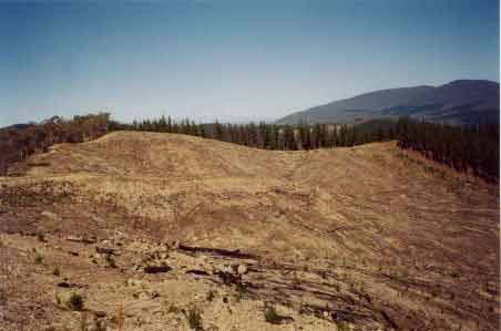
April 2003: Recent clearfelling
inside the Gap Creek Catchment. A 4 km stretch of pine has recently
been logged inside the northern aspect of this plantation. Numerous
problems were identified in the plantation, most notably being the minimal
protection being afforded to natural drainage lines.
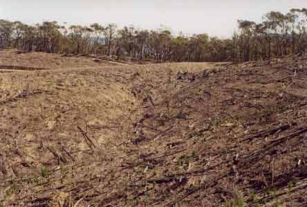
April 2003: More clearfelling
in the Gap creek catchment. No protection for natural drainage lines
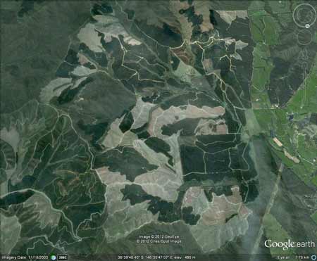
inside the plantation. Hancock Watch Visit Feb 03: Enourmous plantation extending 4km east to west and 5km north to south in the Hurdle Creek catchment. We scouted only the southernmost portion of the plantation. There could be up to a couple of hundred hectares of native vegetation within this plantation although further examination of the area is required. �Special Investigation: North-Eastern Victoria - Ovens Softwood Plantation Zone. Land Conservation Council 1981. p11 Central Region To the north and east of the Eastern Boundary Fault lies an extenisive area of mountainous terrain composed of Ordovician sandstones and mudstones that are less resistant to erosion than the rocks of the south-western region. The drainage pattern is dendritic and the streams are seperated by sharp ridges and spurs. The mountains to the south of Mount Buffalo are typical of this region, which extends east to Mount Beauty and north to Myrtleford. In the north-west around Moyhu and Bobinalwarral the ridges of Ordovician sediments become buried beneath the alluvial deposits of the riverine plain. Within the region, exposures of granitic rocks have intruded into the surrounding Ordovician sediments. Intense heat associated with the intrusions has altered (or metamorphosed) the adjacent sedimentary rocks. The granite outcrops at Mount Buffalo and Mount Emu are extremely resistant, while the surrounding sedimentary rocks which are less resistant have been deeply dissected. In contrast, the granite in the Pinnacles area to the east of Myrtleford is more susceptible to weathering and erosion and as a consequence the terrain in this area is more subdued. A ridge of metamorphic rocks borders Happy Valley to the east of Myrtleford. Friable reddish and brownish gradational soils occur on the Ordovician sediments of this region, while the granitic rocks of Buffalo Plateau and Mount Emu exhibit a variety of soil types. Stony loams are characteristic of rocky outcrops while poorly drained sites contain organic loams and peats. Sandy loams and friable gradational soils are found on the lower slopes of these intrusions. The less resistant granitic rocks at the Pinnacles and Abbeyard carry a variety of gradational soils on the upper slopes and a range of duplex soils at lower elevations. The gradational soils are suitable for softwoods, but the poorly drained duplex soils are not.
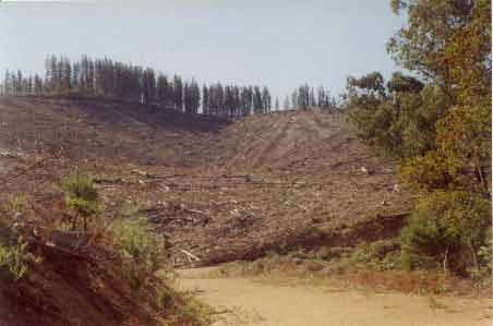
April 2003: Recent clearfelling in the Hurdle
Creek catchment.
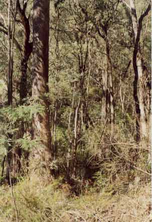
APRIL 2003: A large portion
of the Hurdle Creek catchment (eastern aspect) has an extensive native
vegetation buffer zone extending almost 2km east from Hurdle Creek to
Bread and Butter Track. However much of this plantation retains minimal
buffer zones on natural drainage lines. |