Region: Otways
Legal Number: LEGL/93-42/1 - LEGL/93-43/1
Plantation: Aire Valley
Approximate Size: 1600ha
Conservation Priority: High
Plantation within AKD Softwoods area of supply.
Plantation within SPE Exports (Geelong) area of supply.
Click
here for Otways map.
|
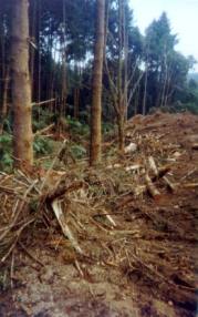 93-43a
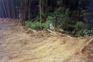
Feb 01: Just off Aire Valley Road upstream of Hopetoun Falls.
Pine bulldozed to edge of drainage line of the Aire River.
Such poor practices are legal within the constraints of the
Code of Forest Practices. Responsibility for enforcing the
Code in plantations rests with local councils and not the
State Government.
93-43a
Feb 01: Just off Aire Valley Road upstream of Hopetoun Falls.
Pine bulldozed to edge of drainage line of the Aire River.
Such poor practices are legal within the constraints of the
Code of Forest Practices. Responsibility for enforcing the
Code in plantations rests with local councils and not the
State Government. |
|
Plantations where the Secretary CNR retains specified rights to
harvest hardwood sawlogs.
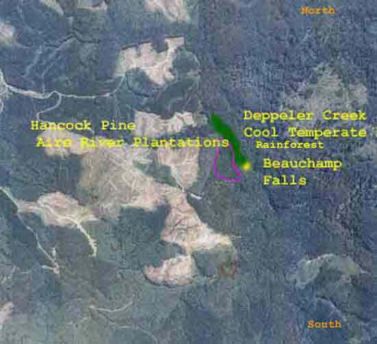
1991 Aerial photgraph of the north eastern
portion of the Aire River Plantations. Beauchamp Falls is marked in
yellow, the cool temperate rainforest of Deppeler Creek is marked in
green. The area marked in purple is an area of hardwoods which the DSE
retains specific rights to log and is a very sensitive area as it is
located in close proximity to Cool Temperate Rainforest. The area in
the north east portion of the photo is State Forest and is not controlled
by Hancock.
This plantation was very likely to be aerially
sprayed with 2,4,5-T between 1968 and 1977. The Dioxin TCDD may still
exist in soil in this plantation. For more historical data on 2,4,5-T
click
here. For more information concerning the
continuing health crisis concerning 2,4,5-T please forward to
here.
Herbicides Used by Hancock
in Pine Plantations - Ballarat Region Victoria
| Herbicide |
Label Rate max as kg/ha |
Used to control |
Notes |
Application |
| Clopyralid |
2.55 |
Woody Weeds |
Highly Toxic/Potential Ground water Contaminant |
air or ground |
| Glufosinate
Ammonium |
1 |
Woody Weeds |
|
|
| Glyphosate |
3.6 |
Herbaceous and woody weeds, noxious weeds |
|
|
| Hexazinone |
4 |
Woody Weeds |
Ground Water Contaminant |
Aerial, ground, spot |
| Metsulfuron-Methyl |
0.06 |
Woody Weeds, Noxious Weeds |
Potential Ground Water Contaminant |
Aerial, ground or spot |
| Triclopyr |
3 |
Woody and Noxious Weeds |
|
Ground, spot, basal bark |
Incomplete Herbicide Regime:
November 1985 - 42 hectares sprayed with 252
litres Velpar
and 420 litres Ulvapron.
December 1988 - 139.3 ha sprayed with 1195
litres of Velpar
and unknown quantity of Ulvapron (probably
1400 litres) on plantation areas established between 1981 and 1987.
October 1990 - 35 hectares sprayed with 137
kg of Velpar
and unknown quantity of Ulvapron (probably
350 litres).
Late 1991 - 62.5 hectares sprayed with 250
kg Velpar
ULW to kill dogwood, fireweed, grass and
blackberry.
July 01: Beauchamp Falls on
Deppeler Creek on the eastern edge of this plantation mass is a major
tourist attraction in the Otways. Pity that punters have to endure wall
to wall pine plantations and very poor potholed 'tourist' roads to get
to this waterfall. That is if they survive likely encounters with log
trucks who compete for roads with tourists.
Land System: Steep slopes of ranges (Aire)*
and Plateaux on crests of ranges (Beech Forest)*.
Geology: Lower Cretaceous sandstone, mudstone.
Landscape: Deeply dissected hills and Rolling
Hills.
Soils: Brown gradational soils.
Forms of soil deterioration: Sheet, rill and
landscape erosion, nutrient decline, surface compaction.
Southernmost boundary of plantation (approx
4km�s) borders West Barham Water Supply Catchment.
Other links: http://www.hancock.forests.org.au/docs/logging_practices_update-0901-2.htm
July 01: Remnant regenerating
vegetation near Beauchamp Falls in the Deppeler Creek catchment. Earmarked
to be logged by Hancock?
THREATENED FISH NOTES - AIRE RIVER: Highest rainfall area
in Victoria. Great habitat values in its mid reaches. Sediment/herbicide
pollution from upstream logging would be a disaster. Some of the best
habitat for Australian
Grayling in the state in the
lower reaches as well as Spotted
Galaxias, Broadfinned Galaxias
and common Tupong
.
THREATENED FISH NOTES - BARHAM RIVER: Does contain Australian
Grayling.
Responsible Authority: Colac Otway Shire Council
Quote of the year 2002: "Colac Otway Shire 6/12/02. Freedom
of Information Request.
In response to your request for information relating to the use
of herbicides by plantation companies, I advise that there are no records
within Council, as plantation companies are not yet required to advise
either Council or the Department of Natural Resources and Environment
of their intention to conduct herbicide applications.
Yours sincerely - Freedom of Information Officer - Colac Otway Shire".
Plantation Catchment: Several small creeks flowing east into
Falls Creek/Barham River East Branch/Mounts Bay Marengo.
Head waters of Falls Creek on edge of plantation. Several creeks flow
NE inside plantation into Walsh Creek/Aire River/Lake Horden.
(North of Aire River-near Beech Forest - Mount Sabine Road): Much of
the upper catchment (4 creek systems) are the headwaters of Deppeler
Creek/Sth Beauchamp Falls/Aire River/Lake Horden.
All of Pulpit Creek catchment and 5 other creek systems/Aire River under
pine.
Entire Congram Creek/Congram falls is under pine (bar head waters of
one tribuatory).
One creek in NW flows east into dam south of Beech Forest.
(South of Aire River): Entire subcatchment/large portion of unnamed
creek/Rileys Ridge/Barham River East Branch/Mounts Bay Marengo is under
pine.
Large portion of the Head waters of north west creeks flowing into Seaview
Creek/Barham River East Branch/Mounts Bay Marengo is under pine.
Entire Head Waters of Clearwater Creek, Farrell Creek, Nigger Creek,
Flanagan Creek, and 3 other unnamed creeks flowing north into Aire River
under pine.
3/4 or 8km's of top part of Aire River is under pine.
"Due to high rainfall in the Aire Valley area - timber is structurally
inferior if harvested at too young an age" DCE - Softwood Assets
Review. January 1991. CS First Boston.
Catchment Managment Authority: Corangamite Catchment Management
Authority
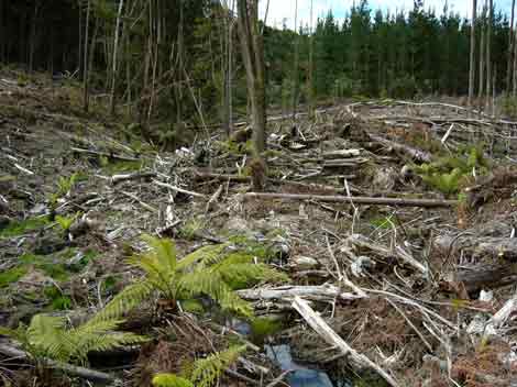
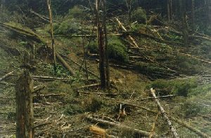
November 2004: Atrocious logging
on a tributary of Congram Creek on the north western area of the Aire
River plantations. This logging would most likely fail an independent
coupe audit as logging refuse has been left in drainage lines. Colac
Otway Shire is the reponsible authority at this site. Is this practice
really certifiable under the Forest Stewardship Council?
Hancock Watch Site visit Feb 01: Huge plantation taking up an
entire valley. Entered area through Aire Valley Road. Drove down Flanagan
Road onto Beauchamp Falls Road. Entered picnic area but due to time
constraints did not do walk onto Deppler Creek (DNRE licence area).
Drove back onto Aire Valley Road, turning righ onto Congrams Break Road.
Drove until the dead end and walked a slight way through pines until
I saw another DNRE licence area - unlogged. Stopped by blackberries.
Drove back onto Aire Valley Road went to Hopetoun Falls took a road
which I believe ran onto Congram Creek Road. Drove until top of hill
which gave view over valley. Drove back down Congram Creek Road, stopped
at a couple of gullies. Drove past Hopetoun Falls picnic area back onto
Aire Valley Road. A couple of hundred metres passed Hopetoun Falls a
recent logging operation had been taking place. Much soil disturbance
with trees (pine) and some wattle had been fallen into gully line. Roading
was dismal with alot of potential erosion occurring.
Contacted Colac-Otway Shire about these activities who carried out a
site inspection on 9/3/01. In a letter dated 19/3/01 from Mark Walker
Environmental Planner "It should be noted that the inspection was
conducted with reference to Chapter 3 of the Code of Forest Practices
for Timber Production. Chapter 3 sets the operational goals and guidelines
for planning, establishment, tending, harvesting, regenerating and roading
of plantations on private land as well as for logging native forest
on private land. The use of Hancock owned land for timber plantations
is a pre-existing land use before the introduction of the new format
planning scheme, as such timber production is not subject to specific
planning permits.
The Code provides for controls on timber harvesting to protect water
quality by maintaining a minimum buffer of 20m for permanent streams,
and a 10m filter strip for temporary streams and drainage lines. Timber
extraction can still take place within the buffer zone provided there
is minimal disturbance by vehicles. Various techniques are available
to facilitate this type of extraction. Subsequent site preparation (for
replanting in the case of plantations) by machinery can occur as close
as 5m to the edge of a permanent stream.
Within the coupe in the site referred to . . . site preparation activities
for replanting has pushed slash to within 10m of the stream edge, however
this is allowable under the code.
Site preparation has been undertaken with a bulldozer and has been designed
to maintain surface roughness and limit catchment size bt creating a
hummocky surface. Increased surface roughness allows rainfall infiltration
and reduces sediment loss from surface run-off. The high level of slash
will additionally trap and reduce sediment loss . . . "
On the other side of the road trees had been taken from very steep
slopes and trees bulldozed into a gully head. Lack of time constrained
me from looking at the southern half of the plantation - need 2 days!
Also see November 2004 Logging Updates
Page
Other Notes: A study of the Land in the catchments of the Otway
Range and Adjacent Plains - Soil Conservation Authority 1981.
*�p52 Aire land system: The steeply dissected spurs and ridges on the
wetter parts of the Otway Range comprise the Aire land system, the largest
land system in the study area... The soils are young and moderately
fertile ... Pine forests cover large areas of this land system... The
main hazards to land use are landslips and sheet erosion. Losses in
organic matter and soil structure are often apparent following clearing.
*p64 Beech Forest land system: Along the crest of the wettest part
of the Otway Range lies a rolling plain with rounded hills and shallow
valleys. This area has one of the highest annual rainfalls in Victoria,
averaging almost 2000mm at Weeaproinah. Prior to settlement late last
century, tall open forests, E.regnans and associated species dominated
the landscape, but now most areas have been cleared for agriculture...The
perennial nature of many of the creeks and drainage lines gives the
area high water catchment values. Conflict also arises between its scenic
appeal as a rural landscape and the conversion of farmland to softwood
plantations�.
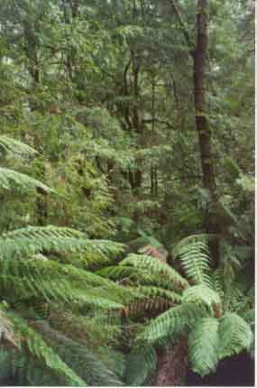
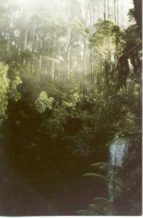
July 01: Cool Temperate Rainforest
on Deppeler Creek on the walk to Beauchamp Falls.
A study of the Land in the catchments of the Otway Range and Adjacent
Plains - Soil Conservation Authority 1981.
p143 "Both establishment and harvesting of hardwood and softwood
forests cause serious changes to the natural hydrological balance. Pine
establishment on disused agricultural land and previously forested land
has led to widespread deterioration. The steep north and west facing
slopes of Lorne, Forrest, Moggs Creek, Aire, Mt Mackenzie, Bunker Hill
and Yahoo Creek land systems are the most severely affected. Sheet erosion
losses can be minimised by working in coupes along the contour, and
by maintaining adequate vegetative cover with litter layers over the
soil surface. The incidence of landslips increases following harvesting,
when the binding effect of tree roots is removed and the soil is subject
to saturation for longer periods. The study area share the current trend
to reduce the total area of productive forest land and manage this smaller
area for higher yields. As with agriculture, nutrients removed in forest
produce need to be replaced through the use of fertilisers. The fertiliser
requirements of soils designated for long-term hardwood and softwood
production require investigation.
p142 Steep slopes in and around drainage lines are more stable under
hardwood than softwood forestry, because of longer growth period and
more selective logging practices".
Aire River: Flows from mountainous forested country to grazing
land. Bottom changes from rock upstream, to mud in lower reaches. Mostly
bushland except for pine plantations in the headwaters and cleared land
below the Great Ocean Road. Carries brown trout to 700g, but most fish
are smaller, river blackfish, tupong, short-finned eels, and some grayling.
Barham River: Fast flowing from mountainous forested country
to grazing land, rock and mud bottom. Some of the stream has been channelised,
while other areas have been modified by agriculture. A small river and
fish do not, on average, grow particulary large. Access is good and
a popular angling water for trout particularly in the headwaters and
for esturaine species. Carries brown trout to 700g, average 140g, short-finned
eels, tupong and some grayling to 180g, with bream and some estuary
perch, mullet, salmon and flounder in the lower reaches.
Source: A Guide to the Inland Angling Waters of Victoria by BR Tunbridge,
PL Rogan, CA Barnham. Department Conservation and Environment. Arthur
Rylah Institute for Environmental Research, 123 Brown St, Heidelberg,
3084. (4th ed - 1991)
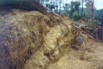
 93-43b Access road bulldozed through 10 feet of soil in possibly the wettest area in Victoria.
 |
 93-43c Just off Aire Valley Road upstream of Hopetoun Falls. More native vegetation destroyed with pine bulldozed near the gully/drainage line. Shot taken in mid-summer in the middle of a 3 year drought.
|
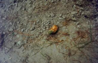 93-43d Pine cone chewed probably by Yellow Tail Black Cockatoo? Pine cones and seeds can be spread through the forest often by birds thereby causing wilding problems by spreading the seeds and cones to places far away from the actual plantation.
|
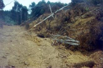
 93-43e Access track construction. OK'd by Colac-Otway Shire. What will happen after a heavy downpour?
|
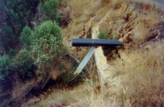 93-43f Innovative culvert design? Congram Creek Road.
 |
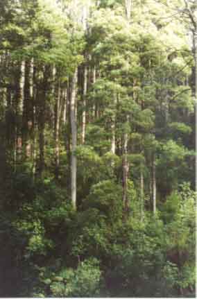
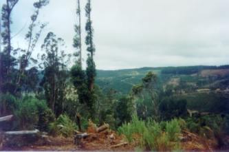 93-43g View looking south into Aire Valley from top of Congram Creek Road. Aire Valley plantations stretch for approximately 6km long by 8 km wide in an area with the heaviest rainfall in Victoria.
|
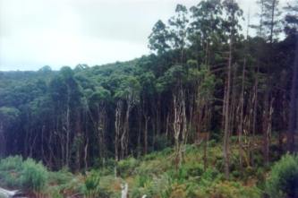 93-43h Native vegetation just off Congram Creek Road. DNRE/hancock have several licence areas throughout the Aire Valley plantations where hardwood can be extracted.
|
 93-43i: July 2001 - Otway Ranges. Appalling creek crossing, with non plantation species cut into gully line. This shot taken off Robbins Road. The creek crossing is through a tributary of Pulpit Creek which flows into the Aire River. No culverts or drains.
|
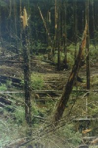
 93-43j: Appalling logging operation off Robbins Road. Note destruction of non-plantation species. July 2001.
 |
 93-43k: Just off the Aire River in a 71 year old Californian Redwood plantation. July 2001.
|
|