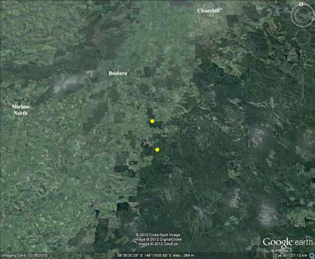
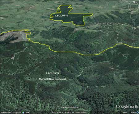
Region: StrzeleckisLegal Number: LEGL/93-76Plantation: LivingstonConservation Priority: High/MedLEGL/93-76: Livingston Block:
|
|
|||||||||||||||||||||||||||||||||||||||||||||||||
|
Plantations located 6km and 10km south east of Boolara.
Plantations incorporate some native forest, particularly within gullies of Morwell River Catchment. Adjoins plantation LEGL93-77 and LEGL93-78 Herbicides Used by Grand Ridge Plantations - Strzelecki Ranges and Gippsland Victoria
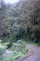
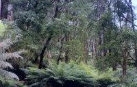
Site visit December 2001:This plantation is in two portions. The most northern portion stretches for 2 km along the eastern side of the Morwell River Road about 6km south east of the town of Boolara. This plantation consists of radiata pine established mainly in the late eighties. The more significant portion of the plantation stretches for about 3km north to south and about 3 1/2 km east to west. This plantation takes in much of the Morwell River West Branch. It is surrounded by farmland to the north and plantations to the east and south. There is some remnant vegetation within this plantation with some buffer zones and areas too steep to log being left to regenerate. These areas consist of ferns, silver wattle and blackwood with some ash also located in the buffers which feed into the Morwell River West Branch and are located mainly on the eastern side of the Morwell River Road. Overall though this area has been degraded by past farming and logging activities. It also has a major weed problem. Much of the western side of the Morwell River West Branch is dominated by ash plantations established from 1958. Much of the area consists of 'plantations' established in the early sixties and 1980's and more work is warranted in determining the quality of the remnant stands of non-plantation of which there appears to be some stands near Cypress Track/off Snowden Road on the far west of the plantation.
|
||||||||||||||||||||||||||||||||||||||||||||||||||
Area within PaperlinX area of supply.Area within Planthard Hardwoods (Drouin West Sawmills) area of supply.Area within Brown and Dureau Softwoods (Morwell) area of supply.This plantation was very likely to be aerially sprayed with 2,4,5-T between 1968 and 1977. The Dioxin TCDD may still exist in soil in this plantation. For more historical data on 2,4,5-T click here. For more information concerning the continuing health crisis concerning 2,4,5-T please forward to here.THOMSON/LATROBE RIVER: THOMSON/LATROBE RIVER: Australian Grayling are found in some streams in the catchment. Used to have a large population of Blackfish, but due to desnagging, sedimentation and destruction of riparian vegetation these populations have declined. Crayfish are an issue in catchment. Responsible Authority: LaTrobe Shire Council Plantation Catchment: Several tribs Bellbrook Creek - north edge runs along Bellbrook Creek/Morwell River/LaTrobe River. Catchment Managment Authority: West Gippsland Catchment Management Authority
December 1966 Aerial Photograph (top = north) of the Morwell River showing that a large proportion of the northern aspect of this future plantation was established on cleared farmland. Remnant Bush at bottom (centre) of photo lies outside existing plantation boundary. Regenerating native forest occurred further south in the catchment. Morwell River, Morwell: Rises in mainly cleared hills, flows in a rock and mud bed through cleared river flats. Dense growth of willows on the banks below Boolara makes fishing difficult. Catchment is steep sided, and erosion has led to some of the middle and lower reaches becoming badly silted. A popular stream with local anglers. Some trout spawning occurs. Contains mainly brown trout to 560g, average is very small, also eels, spiny freshwater crayfish, carp, goldfish, tupong and river blackfish. Source: A Guide to the Inland Angling Waters of Victoria by BR Tunbridge, PL Rogan, CA Barnham. Department Conservation and Environment. Arthur Rylah Institute for Environmental Research, 123 Brown St, Heidelberg, HOME3084. (4th ed - 1991) |
||||||||||||||||||||||||||||||||||||||||||||||||||

.jpg)