|

.jpg)
| Herbicide | Label Rate max as kg/ha | Used to control | Euc/Rad | Notes | Application |
| Clopyralid | 2.55 | Woody Weeds | Radiata and Eucalypts | Highly Toxic/Potential Ground water Contaminant | aerial or ground |
| Glufosinate Ammonium | 1 | Woody Weeds | Radiata | aerial or ground | |
| Glyphosate | 3.6 | Herbaceous and woody weeds, noxious weeds | Radiata, Eucalpts and Custodial | ||
| Haloxyfop-methyl | 0.13 | Annual and Pernneial Grasses | Eucalypts | Carcinogen | aerial or ground |
| Hexazinone | 4 | Woody Weeds | Radiata | Ground Water Contaminant | Aerial, ground, spot |
| Metsulfuron-Methyl | 0.06 | Woody Weeds, Noxious Weeds | Radiata, Eucalyptus and Custodial | Potential Ground Water Contaminant | Aerial, ground or spot |
| Sulfometuron Methyl | 0.6 | Annual and Perennial Grasses and broadleaf weeds | Eucalyptus | Potential Ground Water Contaminant | Aerial or Ground |
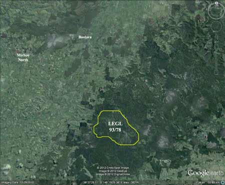
Hancock Watch Site visit December 2001:
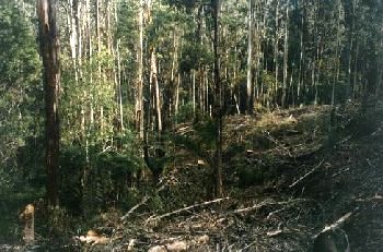
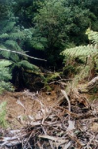
Large land mass bounded by the Grand Ridge Road to the south. It stretches for 5 km north to south and over 6km from west to east. The eastern part of the plantation is bounded by the Midland Highway. This area takes in the entire headwaters and main tributaries of the Morwell River West Branch and the entire area appears to be dominated by hardwood established from the early 1960's - therefore it will be difficult to assatain the difference between plantation and native vegetation regrowth. Much of the regrowth is concentrated in gullies and for several years Victorian Plantation Corporation and Hancock Victorian Plantations were targeting these areas claiming they were plantation. Many of these problems occurred in the western portion of the plantation. Now the loggers are increasingly logging the eastern portion of the plantation. Much of the recent logging is occurring on Radburns Road, Livingston Road and Hatchery Road. Some recent coupes appear to have decent enough buffers but more work is needed identifying and reviewing recent logging activity. Site visit December 01: Drove along northern most boundary of the plantation along Livingston Road. Came across some remnant old growth, however this area may be just outside Hancock's boundary in an area of private land designated inside Hancock's holdings. Most of the Hancock land along Livingston Road consists of hardwood 'plantation' established in 1971. There were a couple of small pockets of non-plantation species, including a small area of Messmate just west of Lens Track. A couple of recent logging operations were observed and one looked particularly messy with an access road being bulldozed through the head of a gully.
THOMSON/LATROBE RIVER: Australian Grayling are found in some streams in the catchment. Used to have a large population of Blackfish, but due to desnagging, sedimentation and destruction of riparian vegetation these populations have declined.Crayfish are an issue in catchment.
Responsible Authority: LaTrobe Shire Council
Plantation Catchment: Many HW creeks Morwell River East Branch/Morwell River/Latrobe River Many tribs Morwell River West Branch
Catchment Managment Authority: West Gippsland Catchment Management
Authority
www.hancock.forests.org.au/docs/morwell.htm#content_top
www.hancock.forests.org.au/docs/legal.htm#content_top
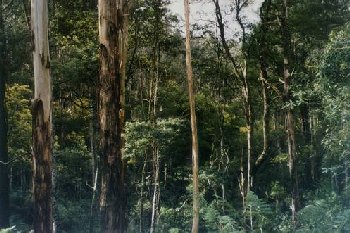
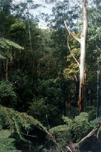
"Morwell West Branch Rainforest: The Morwell West Branch rainforest area is bounded by Lewis Track to the north, the Grand Ridge Road to the west and south and Morwell West Branch Road to the east.
The main area of rainforest on the West Branch of the Morwell River is located on the tributary beginning at the Grand Ridge Road within the area of 1939 regrowth Mountain Ash regrowth. The rainforest extends down the West Branch to where Lewis Track branches off the Morwell West Branch Track. This rainforest contains both myrtle beech and southern sassafras and there are slender tree ferns and skirted tree ferns within this rainforest.
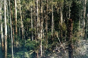
The sections where logging and the development of new plantations occurred in the 1960s/1970s, tend to have only scattered Myrtle Beech.
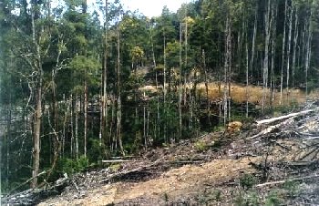
Recent logging operations in 1997/98 have put further areas of this rainforest at risk. On the eastern side of the West Branch clearing has been carried out right to the edge of the rainforest. No buffer has been left to protect the rainforest. This has occurred on the western side at Bell Boulevard. This section of rainforest is now at serious risk of destruction through myrtle wilt and should be monitored.
Morwell West Branch has an important area of 1939 regrowth on the north side of the Grand Ridge Road, opposite the Franklin Reserve. It is important that this area of regrowth be conserved as it provides an extension to the small habitat area of the Franklin Reserve. This has become of major importance since the removal of many habitat trees south of the reserve at Stronach's Road and Red Hill Track.
Most of the remaining old growth and habitat trees in this area
have been removed in logging operations in 1996/97, in the narrow strip
between the tributary and the West Branch Track in Bell Boulevard. However,
there still remains another small area of 1939 regrowth on the south
side of Craig Court. There is also an area of regrowth and native vegetation
on the east side of the West Branch Track below Rodgers Road."
Rainforests of the Strzeleckis by Elaina Fraser.
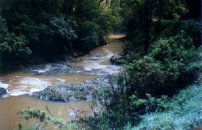 |
Morwell River, Morwell: Rises in mainly cleared hills, flows in a rock and mud bed through cleared river flats. Dense growth of willows on the banks below Boolara makes fishing difficult. Catchment is steep sided, and erosion has led to some of the middle and lower reaches becoming badly silted. A popular stream with local anglers. Some trout spawning occurs. Contains mainly brown trout to 560g, average is very small, also eels, spiny freshwater crayfish, carp, goldfish, tupong and river blackfish.
Source: A Guide to the Inland Angling Waters of Victoria by BR Tunbridge, PL Rogan, CA Barnham. Department Conservation and Environment. Arthur Rylah Institute for Environmental Research, 123 Brown St, Heidelberg, 3084. (4th ed - 1991)
 |
 |
 |
 |
 |
 |