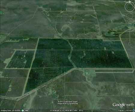
Region: PortlandLegal Number: LEGL/93-4Plantation: Kangaroo ParkPlantation Size: ~400ha
Kangaroo Park plantation lies southeast of the Hotspur State Forest and was probably planted on ex-pasture sites. It has been surrounded by MIS bluegum plantations since 2000. Plantation likely to be located on groundwater recharge area for Port Campbell Limestone Aquifer, which provides irrigation water for the Heywood area.. Plantation maps of region here Plantation located in Portland Groundwater Management Area Plantation located in Condah (Ground) Water Supply Protection Area Conservation Priority: Low - Med
Responsible Authority: Glenelg Shire Council Herbicides Used by Hancock in Pine Plantations South Western Victoria
Ewens Pygmy Perch Plantation Catchment: Northern aspect meets
Hotspur State Forest. Plantation located on Deep Creek and trib of
Deep Creek. 1km upstream of Crawford River/Lake Crawford/Glenelg River. Hancock Watch Site visit Jan 01: Entire area
a pine plantation on relatively flat land. Did not assess buffer zones
on trib of Crawford River. "Groundwater: "In south-western Victoria the Otway Basin stretches from the South Australian border almost to the west of Geelong. It contains older sediments of Upper Cretaceous and Lower Tertiary age, up to 2000 m in thickness. These include four sand aquifers and two limestone aquifers. The sand aquifers of the Wangerrip Group are confined over most of the Basin and their recharge zones are located on the margins of the Otway Range in the east and the Merino Tablelands in the West. The groundwater moves towards the coast, increasing in salinity along its floorpath . . ." p268 State of the Environment Report 1988 Victoria's Inland Waters. Office of the Commissioner for the Environment. "Shallow aquifers in the Glenelg River Basin occur in four main geologic units. Extending from the north-east of the Basin is a fractured rock basement aquifer composed of folded sediment, metamorphics and granite. In the north-east and also in the vicinity of the confluence of the Glenelg and Wannon Rivers, the basement aquifer is overlain by alluvial aquifers from the Quaternary period. The third unit is a Newer Volcanic aquifer which lies along much of the Basin's southern boundary, particularly in the east. This fractured rock aquifer is composed of basalt, scoria and tuff. The fourth unit is composed of dune sand and beach deposits extending from the south-west corner of the Basin up to the western boundary and along the northern boundary. It is known as the Bridgewater formation. A deep aquifer system exists in the south-west of the Basin and extends to the top of the western boundary and half-way across the southern boundary. This sand aquifer, which is significant as a water source, occurs within the Wangerrip Group. Generally, groundwater quality in the Basin decreases towards the north where it is saline. A large reserve of fresh water is held in the north-east corner of the catchment and in the south-west the water is of marginal quality . . ." p295 Water Victoria A Resource Handbook - Department of Water Resources Victoria 1989.
|