Region: PortlandLegal Number: LEGL/93-23Plantation: MocamboroApproximate Plantation Size: 500ha
Conservation Priority: HighThe Nationally Threatened Temperate Grassland & Grassy Eucalypt Woodland Ecological Community may occur in this plantation or in close proximity. Plantation located on Victorian Volcanic Plain Bioregion. More Information: http://www.environment.gov.au/epbc/publications/pubs/grasslands-victoria.pdf Plantation within S.E.A.S Sapfor (Auspine) area of supply. Plantation maps of region here
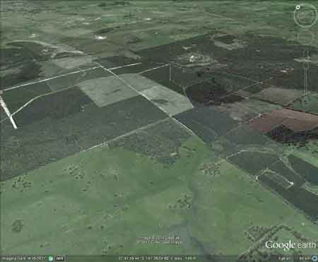
Aerial View of MocamboroPlantations looking north-east. Photo dates from approximately 2005. Declared Water Catchment: Almost entire Plantation located in Merino Proclaimed Water Catchment. Proclaimed 18/12/85.
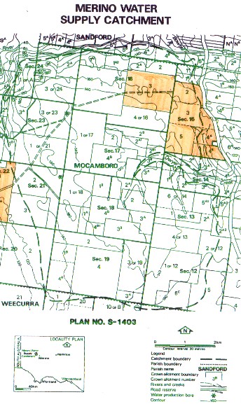
Map showing extent of Hancock plantations within Merino Water Catchment boundaries. This plantation was very likely to be aerially sprayed with 2,4,5-T between 1968 and 1977. The Dioxin TCDD may still exist in soil in this plantation. For more historical data on 2,4,5-T click here. For more information concerning the continuing health crisis concerning 2,4,5-T please forward to here. Herbicides Used by Hancock in Pine Plantations South Western Victoria
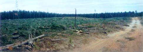
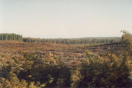
July 2003: Widespread clearfelling
has recently occurred in this very important south west Victorian water
supply catchment. Regrowing pine trees are bound to have a serious impact
on groundwater yield in Merino's water supply catchment. Note
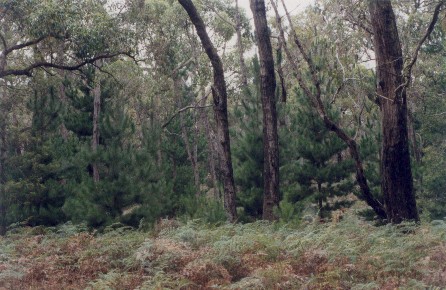
retained indigenous vegetation in right hand side of photo.
Feb 04: Chronic radita pine
weed infestation of Mocamboro native forest.
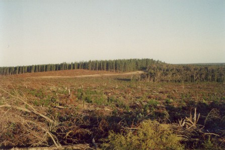
July 2003: View looking south taken from Kilmoc Road. Widespread logging is taking place in this catchment, with clearfells extending over several kilometres in the north eastern aspect of the Merino Water Supply catchment. How much herbicide will be used in this plantation to kill competing native vegetation over the next couple of years? PROPOSAL FOR THE PROCLAMATION OF THE CATCHMENT TO GROUNDWATER BORES IN THE PARISH OF MOCAMBRO (MERINO WATER SUPPLY CATCHMENT). Department Conservation, Forests and Land, April 1985. “p1 The Western Victorian township of Merino (population 300) and approximately 20 outlying rural properties obtain domestic water supply from two groundwater bores. The intake area (“catchment”) of 5,100 ha has been delineated by the Department of Minerals and Energy using geohydrological criteria . . . CLIMATE AND GEOGRAPHY Catchment area: 5,100 hectares. Rainfall: 700 mm per annum. Evaporation: 600mm per annum (net). Geology: Quaternary sands, Tertiary sandstones, marls and limestones. Soils: Coarse loamy sands. Vegetation: Unimproved pasture (760 ha), Dry sclerophyll forest (3843 ha), Softwood plantation (477 ha). Elevation: 100 - 185 metres. Topography: Flat to undulating. Relief: 10 - 20 metres. p2 The Supply System: The two production bores about 2.2km apart, tap a multiple aquifer system at depths between 1 & 85 mm. Their cones of influence are some 400m in radius. The aquifers rely on vertical infiltration of rainwater for recharge with responses to rainfall occurring within a few days. Water is aerated in the bore, pumped to the surface and piped to a retention basin (20 ML) capacity near Merino township. At present the system supplies 50 ML annually. . . Hazards to the Water Supply The major issues confronting management for water supply purposes include small lot subdivision, development of softwood plantations, herbicide and fertilizer use. The Department of Minerals and Energy has expressed concern that the development of softwood plantations on private land, may affect interception and evapotranspiration rates leading to a diminution of the amount of water available to recharge the shallow aquifer. Long term protection of supply is sought, to ensure an adequate quantity of water will be available for future developments. Annual recharge amounts to 120 ML with a projected withdrawal of 100 ML per annum. A further concern is that herbicides, fertilizers, septic
effluent or waste from intensive animal industries may pose a threat
to the quality of the supply. Rapid hydraulic conductivity throughout
the soil profile may not allow sufficient detention time to allow degradation
of pollutants or herbicides such as ‘Roundup’, ‘Velpar’ or ‘Lontrel’.
In times of rapid drawdown such compounds might readily access the water
supply . . .” "Groundwater: "In south-western Victoria the Otway Basin stretches from the South Australian border almost to the west of Geelong. It contains older sediments of Upper Cretaceous and Lower Tertiary age, up to 2000 m in thickness. These include four sand aquifers and two limestone aquifers. The sand aquifers of the Wangerrip Group are confined over most of the Basin and their recharge zones are located on the margins of the Otway Range in the east and the Merino Tablelands in the West. The groundwater moves towards the coast, increasing in salinity along its floorpath . . ." p268 State of the Environment Report 1988 Victoria's Inland Waters. Office of the Commissioner for the Environment. "Shallow aquifers in the Glenelg River Basin occur in four main geologic units. Extending from the north-east of the Basin is a fractured rock basement aquifer composed of folded sediment, metamorphics and granite. In the north-east and also in the vicinity of the confluence of the Glenelg and Wannon Rivers, the basement aquifer is overlain by alluvial aquifers from the Quaternary period. The third unit is a Newer Volcanic aquifer which lies along much of the Basin's southern boundary, particularly in the east. This fractured rock aquifer is composed of basalt, scoria and tuff. The fourth unit is composed of dune sand and beach deposits extending from the south-west corner of the Basin up to the western boundary and along the northern boundary. It is known as the Bridgewater formation. A deep aquifer system exists in the south-west of the Basin and extends to the top of the western boundary and half-way across the southern boundary. This sand aquifer, which is significant as a water source, occurs within the Wangerrip Group. Generally, groundwater quality in the Basin decreases towards the north where it is saline. A large reserve of fresh water is held in the north-east corner of the catchment and in the south-west the water is of marginal quality . . ." p295 Water Victoria A Resource Handbook - Department of Water Resources Victoria 1989.
|