Region: Portland
Legal Number: LEGL/93-2
Plantation: Lyon's
|
 93-2d Jan 01: DNRE/Hancock
licence area. Northern Lyons plantation. Native vegetation
at this site could be logged in the future?.
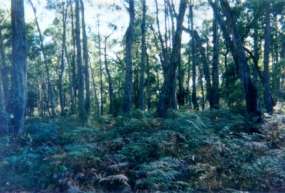
93-2d Jan 01: DNRE/Hancock
licence area. Northern Lyons plantation. Native vegetation
at this site could be logged in the future?. |
|
Conservation Priority: High
Plantation located in Portland
Groundwater Management Area
The Nationally Threatened Temperate
Grassland & Grassy Eucalypt Woodland Ecological Community may occur
in this plantation or in close proximity.
Plantation located on Victorian
Volcanic Plain Bioregion.
More Information:
http://www.environment.gov.au/epbc/publications/pubs/grasslands-victoria.pdf
Plantation within S.E.A.S Sapfor (Auspine) area of
supply.
Plantation within AKD Softwoods area of supply.
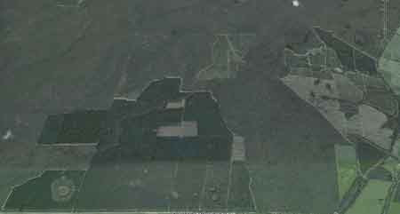
Google Earth image early 2001: Emerson plantation
lies alongside Cobboboonee State Forest.
Responsible Authority: Glenelg Shire Council
Plantation where the Secretary CNR (now Department of Natural Resources
and Environment) retains specified rights to harvest hardwood sawlogs.
Herbicides Used by Hancock
in Pine Plantations South Western Victoria
|
Herbicide
|
Label Rate max as kg/ha
|
Used to control
|
Notes
|
Application
|
|
|
2.55
|
Woody Weeds
|
Highly Toxic/Potential Ground water Contaminant
|
air or ground
|
|
|
3.6
|
Herbaceous and woody weeds, noxious weeds
|
|
|
|
|
4
|
Woody Weeds
|
Ground Water Contaminant
|
Aerial, ground, spot
|
|
|
0.06
|
Woody Weeds, Noxious Weeds
|
Potential Ground Water Contaminant
|
Aerial, ground or spot
|
|
|
3
|
Woody and Noxious Weeds
|
|
Ground, spot, basal bark
|
THREATENED FISH NOTES - GLENAULIN CREEK/CRAWFORD RIVER: Only
known habitat for FFG listed Ewens
Pygmy Perch in Victoria.
THREATENED FISH NOTES - GLENELG RIVER: Yarra Pygmy Perch and
Ewens
Pygmy Perch found in the Glenelg
system. Both species listed under the Flora and Fauna Guarantee Act
in Victoria and threatened.

Ewens Pygmy Perch
Plantation Catchment: Southern creek drains into Fitzroy River.
Northern creek flows into Springburn Creek/Crawford River?/Glenelg River.
Plantation lies near swamp land to the west.
Catchment Management Authority: Glenelg-Hopkins Catchment Management
Authority.
Hancock Watch Site Visit Jan 01: Checked out native veg area
where DNRE still retains rights to log. This area lies between Red Hill
Track and Bear Park Track. The area consists of regrowth and some older
trees with what appears to be a wetland in the northern portion of the
area. This area is vital corridor between state forest on either side
of the plantation. Area also connected to other DNRE area in the south
of the plantation (which consists of regrowth) by an extensive buffer
zone. The buffer area appears to run through the plantation connecting
the two DNRE areas. Older trees exist in the buffer zone in what appears
to be a trib of the Fitzroy river. A track from Bear Park Track called
S3 runs along the buffer zone. The southern plantation on the eastern
side has a strip of native vegetation between 100 m and 50 m thick running
along the road on the eastern edge of the plantation. On the other side
is paddocks, thus this native vegetation is all that remains. Also checked
out eastern edge of northern plantation. There is another small DNRE
licence area of young stringybark that warrants protection.
Crawford River: Flows through forest and grazing land, mud bottom. Contains
mostly redfin, river blackfish, eels and abundant spiny freshwater crayfish,
and tench. A popular angling water. Currently no stocking with any species
as stream tribuataries contain variegated pigmy perch, which is a species
listed under the Flora and Fauna Guarantee Act 1988 as requiring protection.
Source: A Guide to the Inland Angling Waters of Victoria by BR Tunbridge,
PL Rogan, CA Barnham. Department Conservation and Environment. Arthur
Rylah Institute for Environmental Research, 123 Brown St, Heidelberg,
3084. (4th ed - 1991)
According to current records, the Variegated Pygmy Perch is restricted
to south-western Victoria and adjacent areas of south eastern South
Australia. Despite intensive collecting efforts between 1983 and 1985,
the species was found at only two localities; Glenaulin Creek (the type
locality) at Winnap, Victoria, and Ewen's Ponds in South Australia (Kuiter
& Allen 1986).
A 1990 survey of the waters in the Crawford River and Glenaulin Creek
area undertaken by the then Department of Conservation and Environment
identified several locations where the species exists in tributaries
of the Crawford River and Glenelg River. Three locations were in Glenaulin
Creek, near the location previously surveyed by Kuiter and Allen. It
also appears that the population has returned to a healthy state in
the streams feeding Ewen's Ponds.
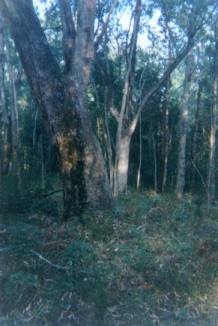 93-2b Jan 01: Buffer zone
of tributary of Fitzroy River, about 500m from S3 track (off Bear
Park Track).
93-2b Jan 01: Buffer zone
of tributary of Fitzroy River, about 500m from S3 track (off Bear
Park Track). |
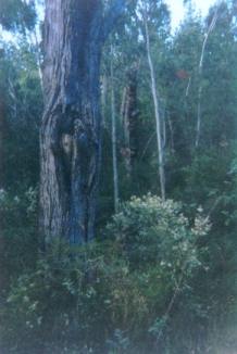 93-2c Jan 01: Buffer zone
of tributary of Fitzroy River, about 500m from S3 track (off Bear
Park Track). Note pines in background.
93-2c Jan 01: Buffer zone
of tributary of Fitzroy River, about 500m from S3 track (off Bear
Park Track). Note pines in background. |
HOME
"Groundwater: "In
south-western Victoria the Otway Basin stretches from the South Australian
border almost to the west of Geelong. It contains older sediments
of Upper Cretaceous and Lower Tertiary age, up to 2000 m in thickness.
These include four sand aquifers and two limestone aquifers. The sand
aquifers of the Wangerrip Group are confined over most of the Basin
and their recharge zones are located on the margins of the Otway Range
in the east and the Merino Tablelands in the West. The groundwater
moves towards the coast, increasing in salinity along its floorpath
. . ." p268 State of the Environment Report 1988 Victoria's
Inland Waters. Office of the Commissioner for the Environment.
"Shallow aquifers in the Glenelg River Basin
occur in four main geologic units . . . The third unit is a Newer
Volcanic aquifer which lies along much of the Basin's southern boundary,
particularly in the east. This fractured rock aquifer is composed
of basalt, scoria and tuff. The fourth unit is composed of dune sand
and beach deposits extending from the south-west corner of the Basin
up to the western boundary and along the northern boundary. It is
known as the Bridgewater formation.
A deep aquifer system exists in the south-west of
the Basin and extends to the top of the western boundary and half-way
across the southern boundary. This sand aquifer, which is significant
as a water source, occurs within the Wangerrip Group.
Generally, groundwater quality in the Basin decreases
towards the north where it is saline. A large reserve of fresh water
is held in the north-east corner of the catchment and in the south-west
the water is of marginal quality . . ." p295 Water Victoria
A Resource Handbook - Department of Water Resources Victoria 1989.
|