Region: Portland

Legal Number: LEGL/93-18

Plantation: Rennick

Conservation Priority: High

Aerial View of Rennick Plantation looking south in 2001.

Plantation within S.E.A.S Sapfor (Auspine) area of supply.
Plantation within AKD Softwoods area of supply.

The Nationally Threatened Temperate Grassland & Grassy Eucalypt Woodland Ecological Community may occur in this plantation or in close proximity.

Plantation located on Victorian Volcanic Plain Bioregion.

More Information:

http://www.environment.gov.au/epbc/publications/pubs/grasslands-victoria.pdf

Plantation maps of region here

Plantation located in Glenelg Water Supply Protection Area

Plantation located in Zone 1B South Australian-Victorian Border Groundwaters Agreement

"The Review Committee is mindful of the declining trends in Zones ...1B... Conversely the development of extensive plantation forests reduces the recharge compared to open pasture. The location where forest plantations will have a significant impact on groundwater supplies is in Province 1 where extensive plantation forests have been developed in this region for over the last half-centuy" p15

Tertiary Limestone Aquifer in Zone 1B showing long term groundwater decline since 1972 and groundwater decline since 1992/3. p22

"Long-term declining groundwater trends (30 years as observed by the hydrographs) occur in ... the area south of the Glenelg River in Zone 1B. Since 1972 the total change in water level over that period is ~3.5m, which equates to a rate of decline of 0.11m/y. The seasonal fluctuation in water levels is negligible indicating little recharge from rainfall or seasonal extraction from groundwater extraction. These areas are located beneath plantation forests and are indicative of the impact that plantation forests have on rainfall recharge" p26 South Australian - Victorian Border Groundwaters Agreement Review Committee 21st Annual Report to June 2006

"Forestry. Existing areas of plantation forests and native vegetation were taken into account in computing vertical recharge and hence the quantity of water available. Expansion of forests in the Designated Area needs to be monitored to consider the impact of the current Permissable Annual Volumes. It has the potential to significantly reduce the total vertical recharge to the aquifer, which may necessitate the need to reduce existing Allowable Annual Volumes, and therefore licensed allocations.

Low recharge rates under pinus radiata and under blue gums have been assigned in the determination of vertical recharge. Further research is required to evaluate the impacts on recharge. Blue gums and pinus radiata may extract groundwater as well as intercept rainfall where the depth to groundwater is within their rooting depth. A management approach is required to handle further forestry expansion otherwise allowable annual volumes may have to be reduced progressively in response to assessed vertical recharge"p17 Border Groundwaters Agreement Review Committee Five Year Management Review Report 1996-2000


THREATENED FISH NOTES - GLENELG RIVER: Yarra Pygmy Perch and Ewens Pygmy Perch found in the Glenelg system. Both species listed under the Flora and Fauna Guarantee Act in Victoria and threatened.

Responsible Authority: Glenelg Shire Council

Plantation Catchment: East borders start of creek which flows into drain/Glenelg River.

Catchment Managment Authority: Glenelg-Hopkins Catchment Management Authority.

Herbicides Used by Hancock in Pine Plantations South Western Victoria

Herbicide
Label Rate max as kg/ha
Used to control
Notes
Application
2.55
Woody Weeds
Highly Toxic/Potential Ground water Contaminant
air or ground
3.6
Herbaceous and woody weeds, noxious weeds
4
Woody Weeds
Ground Water Contaminant
Aerial, ground, spot
0.06
Woody Weeds, Noxious Weeds
Potential Ground Water Contaminant
Aerial, ground or spot
3
Woody and Noxious Weeds
Ground, spot, basal bark


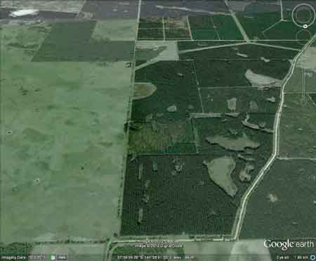
Hancock Watch Site visit Jan 01: Almost the entire plantation is pine however there appears to be a strip of native vegetation at the southern most extremity of the plantation a couple of hundred metres across in size. This is important as it adjoins native veg of LEGL/93-17.

Glenelg River: Casterton to Coast - Flows through forest and grazing land, mud bottom. Contains a few brown trout and rainbow trout from small self-supporting populations near Casterton and some Redfin to 450g. Estuary fish extend upstream for 60km. This section is within a National Park and is accessible by road and boats. Carries bream to 900g, mullet, salmon, estuary perch, mulloway to 7kg with occasional larger fish, luderick and flounder.

Source: A Guide to the Inland Angling Waters of Victoria by BR Tunbridge, PL Rogan, CA Barnham. Department Conservation and Environment. Arthur Rylah Institute for Environmental Research, 123 Brown St, Heidelberg, 3084. (4th ed - 1991)

HOME

"Groundwater: "In south-western Victoria the Otway Basin stretches from the South Australian border almost to the west of Geelong. It contains older sediments of Upper Cretaceous and Lower Tertiary age, up to 2000 m in thickness. These include four sand aquifers and two limestone aquifers. The sand aquifers of the Wangerrip Group are confined over most of the Basin and their recharge zones are located on the margins of the Otway Range in the east and the Merino Tablelands in the West. The groundwater moves towards the coast, increasing in salinity along its floorpath . . ." p268 State of the Environment Report 1988 Victoria's Inland Waters. Office of the Commissioner for the Environment.

"Shallow aquifers in the Glenelg River Basin occur in four main geologic units . . . The third unit is a Newer Volcanic aquifer which lies along much of the Basin's southern boundary, particularly in the east. This fractured rock aquifer is composed of basalt, scoria and tuff. The fourth unit is composed of dune sand and beach deposits extending from the south-west corner of the Basin up to the western boundary and along the northern boundary. It is known as the Bridgewater formation.

A deep aquifer system exists in the south-west of the Basin and extends to the top of the western boundary and half-way across the southern boundary. This sand aquifer, which is significant as a water source, occurs within the Wangerrip Group.

Generally, groundwater quality in the Basin decreases towards the north where it is saline. A large reserve of fresh water is held in the north-east corner of the catchment and in the south-west the water is of marginal quality . . ." p295 Water Victoria A Resource Handbook - Department of Water Resources Victoria 1989.


S.E.A.S Sapfor Ewens Pygmy Perch Auspine Yarra Pygmy Perch Redfin Trout Glenelg River Victree Medium Portland