Plantation maps of region here The Nationally Threatened Temperate Grassland & Grassy Eucalypt Woodland Ecological Community may occur in this plantation or in close proximity. Plantation located on Victorian Volcanic Plain Bioregion. More Information: http://www.environment.gov.au/epbc/publications/pubs/grasslands-victoria.pdf
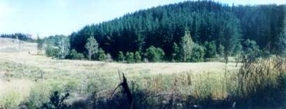
Glenaulin Creek in foreground, with 'generous' buffers. Plantation lies in the north west of Cobboboonee Forest, 9km south east of the township of Dartmoor. Plantation located in Portland
Groundwater Management Area Plantation within S.E.A.S Sapfor (Auspine) area of
supply. Plantation within AKD Softwoods area of supply.
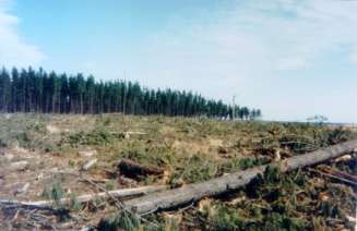
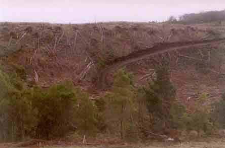
May 04: Recent clearfelling of pine just south of Glenaulin Creek. Fair buffer on this site. Application of Hexazinone will most likely occur in a year or so. This plantation was very likely to be aerially sprayed with 2,4,5-T between 1968 and 1977. The Dioxin TCDD may still exist in soil in this plantation. For more historical data on 2,4,5-T click here. For more information concerning the continuing health crisis concerning 2,4,5-T please forward to here. Herbicides Used by Hancock in Pine Plantations South Western Victoria
Responsible Authority: Glenelg Shire Council
May 04: Glenaulin Creek. Note
close proximity of pine plantations.
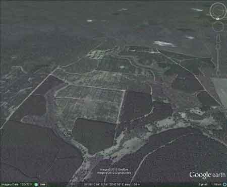
Ewens Pygmy Perch Plantation Catchment: Located in the north of Cobboboonee State Forest. Deep Creek, Horse Creek, Bacci Creek all flow into Glenaulin Creek which flows into the Glenelg River, south of Dartmoor. Plantation also located on Glenaulin Creek. Plantation located in the south west of the Glenelg catchment, near several swamps such as Cordover and Island Swamp. The plantation extends for 5km east to west and 3-4km north to south. Catchment Management Authority: Glenelg-Hopkins Catchment Management Authority.
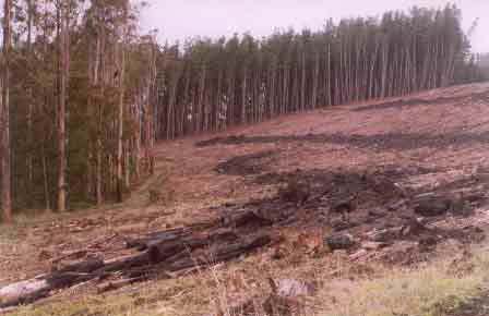
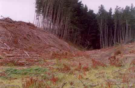
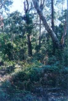
May 04: Probably Horse Creek which is a tributary of Glenaulin Creek. This access track cut into the hillside probably breaches the Code of Forest Practice. Click here for more information about the Glenelg/Hopkins region. Hancock Watch Site Visit Jan 01: Quite large regrowth - DNRE licence area (possibly with older trees) lies in the approximate centre of plantation area. Drove south onto Baggate Road - turned west until Emerson Plantation Road. Headed north on western side of road DNRE concession area. Headed to Glenaulin Creek region - habitat for Ewens Pygmy Perch. Pines in upper catchment. Drove through extensive area of regrowth with some older trees (red gums) along Bacci Creek. This area is vital for habitat reasons and is a vital buffer zone. Saw evidence of recent harvesting in pine area west of Emerson Plantation Road. Glenaulin Creek: Stronghold of Ewens Pygmy Perch. (FFG). Weyerhauser Plantations also in close proximity. According to current records, the Variegated Pygmy Perch is restricted to south-western Victoria and adjacent areas of south eastern South Australia. Despite intensive collecting efforts between 1983 and 1985, the species was found at only two localities; Glenaulin Creek (the type locality) at Winnap, Victoria, and Ewen's Ponds in South Australia (Kuiter & Allen 1986).
May 04: Drainage line of Horse Creek which has been logged. Logging machinery has also run through this drainage line.
A 1990 survey of the waters in the Crawford River and Glenaulin Creek area undertaken by the then
Department of Conservation and Environment identified several locations where the species exists in
tributaries of the Crawford River and Glenelg River. Three locations were in Glenaulin Creek, near the location previously surveyed by Kuiter and Allen. It also appears that the population has returned to a
healthy state in the streams feeding Ewen's Ponds.
Source: A Guide to the Inland Angling Waters of Victoria by BR Tunbridge, PL Rogan, CA Barnham. Department Conservation and Environment. Arthur Rylah Institute for Environmental Research, 123 Brown St, Heidelberg, 3084. (4th ed - 1991)
"Groundwater: "In south-western Victoria the Otway Basin stretches from the South Australian border almost to the west of Geelong. It contains older sediments of Upper Cretaceous and Lower Tertiary age, up to 2000 m in thickness. These include four sand aquifers and two limestone aquifers. The sand aquifers of the Wangerrip Group are confined over most of the Basin and their recharge zones are located on the margins of the Otway Range in the east and the Merino Tablelands in the West. The groundwater moves towards the coast, increasing in salinity along its floorpath . . ." p268 State of the Environment Report 1988 Victoria's Inland Waters. Office of the Commissioner for the Environment. "Shallow aquifers in the Glenelg River Basin occur in four main geologic units . . . The third unit is a Newer Volcanic aquifer which lies along much of the Basin's southern boundary, particularly in the east. This fractured rock aquifer is composed of basalt, scoria and tuff. The fourth unit is composed of dune sand and beach deposits extending from the south-west corner of the Basin up to the western boundary and along the northern boundary. It is known as the Bridgewater formation. A deep aquifer system exists in the south-west of the Basin and extends to the top of the western boundary and half-way across the southern boundary. This sand aquifer, which is significant as a water source, occurs within the Wangerrip Group. Generally, groundwater quality in the Basin decreases towards the north where it is saline. A large reserve of fresh water is held in the north-east corner of the catchment and in the south-west the water is of marginal quality . . ." p295 Water Victoria A Resource Handbook - Department of Water Resources Victoria 1989.
|