


Jan 05: Strzelecki Ranges - Morwell River catchment - Gunyah area. This photo is supposed to be plantation that Hancock have applied to log, despite concern and lack of consultation with local stakeholders. Hancock have applied for a permit to remove native vegetation near the Grand Ridge Road and Morwell River Road. GRP has proposed to enter the southern section of the coupe via the Grand Ridge Road, an area registered on the National Estate, part of the Gunyah Core Area, as one of its options. The coupe plan indicates that GRP intends to log in the Core area and in sections, which are not part of the planted estate. The GRP mitigation analysis makes no reference to the fact that the forests are considered to be high conservation value forest (HCVF) as per the Smartwood assessment 2002, containing significant fauna species including the only known endemic (non-translocated) population of Koala in Victoria.

Jan 05: Strzelecki Ranges - Morwell River catchment - Gunyah area on left of map. The area in red circle is where Hancock are proposing to enter the area. This is part of the Cores and Links. How much more of the Cores and Links are Hancock proposing to log? Is the area marked as hardwood 'plantation' on the above map (in purple) actually plantation. Groundtruthing has revealed problems with this assumption. Why didn't the company consult with stakeholders before they applied to log this area?
In June 2004, the FSC certifier Smartwood conducted an audit of Hancock's operations in the Strzelecki Ranges. Hancock was issused with a new Corrective Action Request relating to the Cores and Links which was;
CAR-2004: GRP shall postpone plantation harvesting operations from the proposed Cores and Links identified in the Biodiversity Study until the process required under Condition 9.1.1 is complete, and/or there is broad stakeholder input on the specific precautions/strategies that should be put in place so that any harvesting which occurs in the proposed Cores and Links will maintain high conservation values.

Jan 05: Strzelecki Ranges - Morwell River catchment - Gunyah area. Native vegetation Hancock have applied to clear which separates the 2 supposed plantations. This is flat land, weed free with beautiful habitat trees. This is part of GRP*'s application to clear this area to gain access to a "planted" coupe. *GRP = Grand Ridge Plantations, a subidiary of Hancock Victorian Plantations.
A protocol was established by the Strzelecki Working Group (SWG) in May and August 2004, whereby prior to entry to the areas in the Cores and Links, BIOSIS Research would groundtruth the boundaries.
A MOU with the Trust for Nature and the Nature Conservancy and Grand Ridge Plantations was signed in October 2004 to protect the high biodiversity values of the Cores and Links. Prior to any buy-back of the leasehold rights to this land, BIOSIS would be engaged to ground-truth the boundaries. On this basis it would then be determined if areas were to be extended or excluded from the existing boundaries based on their conservation significance. By applying for a permit to log this area before the groundtruthing has been carried out, are GRP attempting to undermine the SWG protocol and the MOU with the Trust for Nature and the Nature Conservancy?

Jan 05: Strzelecki Ranges - Morwell River catchment - Gunyah area. Native vegetation Hancock have applied to clear which separates the 2 supposed plantations. This is flat land, weed free with beautiful habitat trees. This is part of GRP*'s application to clear this area to gain access to a "planted" coupe. *GRP = Grand Ridge Plantations, a subidiary of Hancock Victorian Plantations.

as above

Jan 05: Strzelecki Ranges - Morwell River catchment - Gunyah area. This photo was taken in the southern coupe in the supposed planted estate. Is this really a plantation!?

as above

as above
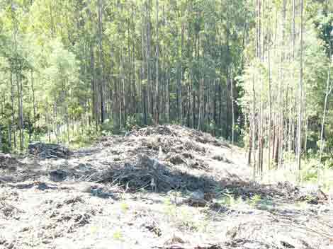
January 2005 Morwell River East Branch Parish of Jumbuk - ex APM Leasehold land. Only 20 metre buffers retained at this location on cool temperate rainforest. These buffers are a disgrace. This coupe was logged after the following CAR was drafted by Smartwood an FSC certifier. Why wasn't the CAR adhered to? Which stakeholders were consulted about these measely buffers?
In June 2004, the FSC certifier Smartwood conducted an audit of Hancock's operations in the Strzelecki Ranges. Hancock was issued with a new Corrective Action Requests which was;
"CAR 1 -2004: The Rainforest Management BMP shall be completed by 1 March 2005 including an independent peer review and further stakeholder input. The current accepted practice of stakeholder involvement in boundary marking is to continue with coupes where HVP/GRP harvests plantations adjacent to any areas of Cool or Warm Temperate Rainforest.
Observation 1 -2004: Given stakeholder concerns and limitations, GRP should explore short-term alternative mechanisms for ensuring that it can obtain stakeholder input into the design of rainforest buffers and related management activities until such time that the Rainforest Management BMP is completed and practices dictated by the new BMP are fully internalized by HVP/GRP staff."
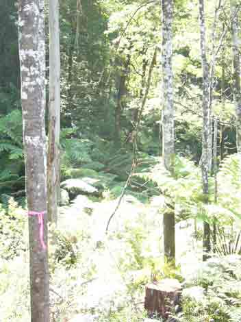
January 2005 Morwell River East Branch - Parish of Jumbuk - ex APM Leasehold land. Despite only granting buffers of 20 metres on cool temperate rainforest at this site, Hancock still managed to log this tree inside their own buffer which had been previously marked with tape.
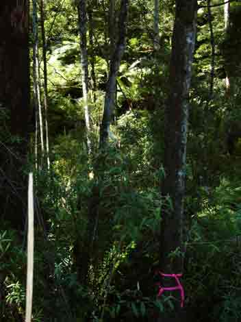
January 2005 Morwell River East Branch - Parish of Jumbuk - ex APM Leasehold land. Only 20 metre buffers measured at this location on cool temperate rainforest. Buffers of this size simply will not do.
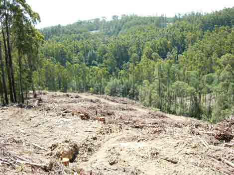
January 2005 Morwell River East Branch Parish of Jumbuk - ex APM Leasehold land. View looking down recent logging coupe into tributary containing cool temperate rainforest. Minimal buffers at this location.
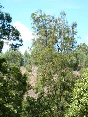
January 2005 Morwell River East Branch - Parish of Jumbuk - ex APM Leasehold land. View looking across Tributary containing cool temperate rainforest. Recent logging had only granted 20 - 30 metre buffers on rainforest.
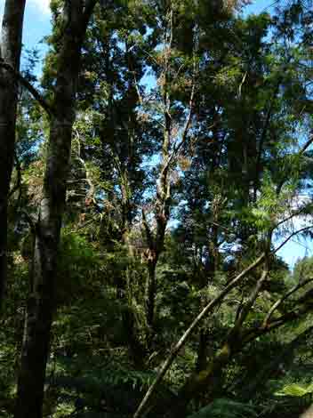
January 2005 Parish of Jumbuk - ex APM Leasehold land. Myrtle Wilt occurring on Myrtle Beech trees on tributary of Morwell River East Branch .
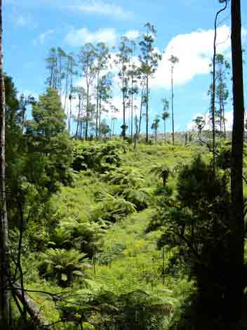
January 2005 Morwell River East Branch - Parish of Jumbuk - ex APM Leasehold land. Recent clearfelling near this natural drainage line.

Jan 05: Smiths Creek catchment which drains into Middle Creek on the northern slopes of the Strzeleckis. A small stand of rainforest occurs in this catchment.

Jan 2005: Otway Ranges - Recent clearfelling in the Aire River Plantations.

Jan 2005: Otway Ranges - Recent clearfelling in the Aire River Plantations. Congram Creek Catchment. Appalling logging operation. Logging debris left in waterway. Buffers to this flowing creek were almost non-existent.

Jan 2005: Otway Ranges - Recent clearfelling in the Aire River Plantations. Congram Creek Catchment. Poorly made creek crossing.

Jan 2005: King Parrot Creek catchment near King Lake West. Roading in drainage line. Mt Robertson plantation.

Jan 2005: Mt Robertson plantation. Poorly located roading "quarry" in very close proximity to Stony Creek, a tributary of King Parrot Creek.

Jan 2005: Mt Robertson plantation.King Parrot Creek catchment near King Lake West. This clearfell on the eastern side of King Parrot Creek was several kilometres in size.

Jan 2005: Mt Robertson plantation. Dozer tracks through drainage line in Mathiesson Creek catchment, a tributary of King Parrot Creek. Dozers created puddling of water where drainage line meets the logging road.

Jan 2005: Mt Robertson plantation. Would you like a drink of water? Drainage line which dozers had run through in above photo. Mathiesson Creek catchment, a tributary of King Parrot Creek.