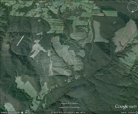
Conservation Priority: HighPlantation within Australian Newsprint Mill (ANM) Ltd area of supply.Plantation within Dominance Industries (Alpine MDF Industries) area of supply.Strathbogies and Central North East Plantation Map here |
| Herbicide | Label Rate max as kg/ha | Used to control | Notes | Application |
| Carfentrazone-Ethyl | 0.036 | |||
| Clopyralid | 2.55 | Woody Weeds | Highly Toxic/Potential Ground water Contaminant | air or ground |
| Glyphosate | 3.6 | Herbaceous and woody weeds, noxious weeds | ||
| Hexazinone | 4 | Woody Weeds | Ground Water Contaminant | Aerial, ground, spot |
| Metsulfuron-Methyl | 0.06 | Woody Weeds, Noxious Weeds | Potential Ground Water Contaminant | Aerial, ground or spot |
| Triclopyr | 3 | Woody and Noxious Weeds | Ground, spot, basal bark |
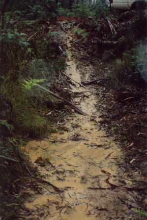
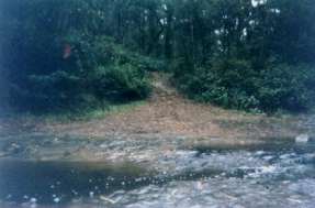
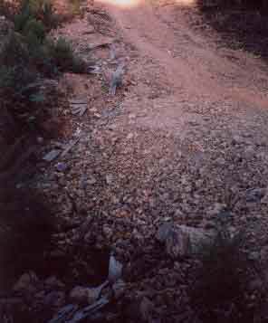
May 2003: Sediment entering unnamed tributary of King Parrot Creek after light rainfall. This particular 'waterway' would turn into a torrent after heavy rainfall. Creek side buffers at this location do not stop sediment laden water from entering the King Parrot Creek system. Roading is a major contributor of sediment loads into waterways.
Water Catchment Area: GOULBURN
RIVER CATCHMENT POTENTIAL WATER FOR AVENEL, CONGUPINA, MOOROOPNA, MURCHISON,
NAGAMBIE, SEYMOUR, SHEPPARTON, TALLAROOK, TALLYGAROOPNA, TOOLAMBA
MURRAY RIVER SUPPLIES WATER TO BARMAH, ECHUCA , KERANG, PIANGIL, SWAN
HILL, ROBINVALE, MILDURA
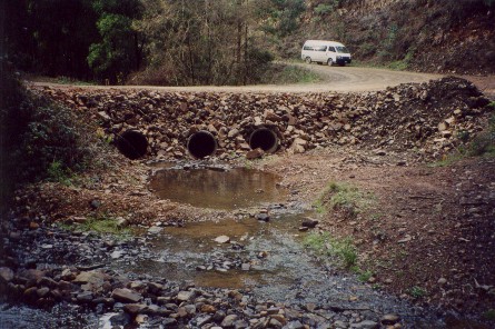
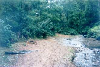
May 2003: Recent work on the creek crossing in Stony Creek. Large piles of rock and stone now abut the creek and trail bike riders are still accessing the creek by riding over the pile of rocks - to the right of the photo. 4WD's have not however been able to access the creek. Large amounts of turbid water have been seen on the other side of the Creek, especially after rainfall events.
THREATENED FISH NOTES - GOULBURN RIVER: Seven Creeks has the only self sustaining population of Trout Cod in Victoria - below Polly McQuinns dam.� Seven Creeks also has a big population of Macquarie Perch. Macquarie Perch are also present at the bottom of King Parrot creek.� Macquarie Perch have disappeared from the Goulburn largely due to dams, flow reduction and sedimentation.� Two Spined Blackfish inhabit the mid to upper reaches of streams north of the Great Divide, whereas River Blackfish inhabit lower reaches of streams north of the Divide.� The Acheron river has populations of Blackfish and Mountain Galaxias/possibly Barred Galaxias also.
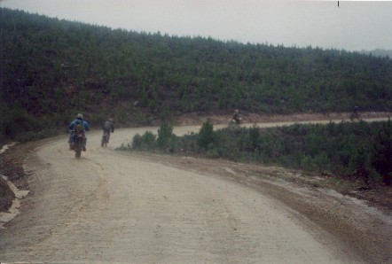
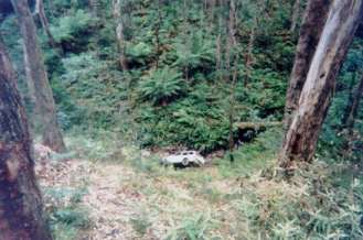
May 2003: Trailbike riders in Stony Creek catchment. 4WD and motorbike riders can cause all sorts of sediment problems in plantations, particularly plantations located close to urban areas. Increased traffic usage on logging roads can greatly increase sediment loads into local waterways.
Responsible Authority: Murrundindi Shire Council
Plantation Catchment: Portion Stoney Creek, Mathieson Creek, Pheasant Creek/King Parrot Creek/Goulburn River as well as a couple of unnamed creeks flowing into King Parrot Creek. Plantation takes up 1087ha of land in the King Parrot Creek catchment.
Catchment Managment Authority: Goulburn Broken Catchment Management Authority.
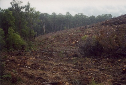
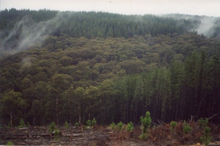
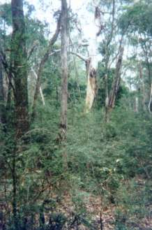
May 2003: Native vegetation removal near unnamed tributary of King Parrot Creek. If native species regenerate inside plantation areas, the native species will often be destroyed during logging and the area replanted with plantation species. Most of the western portion of the Mount Robertson plantations (about 500 ha) has been logged in the past 2 years. The Mount Robertson plantations probably consume 2200 million litres of water more per year, than if the land was retained as farmland. Because the plantation trees are forever young, they will always be thirsty for water.
Hancock Watch Site visit April 2000: Tipped off by local fishermen about poor quality of logging roads on Stony Creek. Contacted Murrundindi Shire - some unsatisfactory remedial work and barring of logging tracks was done by Hancock.
Hancock. Site visit - Jan 01: Travelled into eastern portion of plantation from the south (Watsons Road). Logging contractors active at site. Saw substantial native vegetation buffer zone on Mathieson Creek and large portion of native vegetation including old growth on western edge of Pheasant Creek (far eastern boundary of plantation). Saw poor quality logging roads including bombsite on northern edge of plantation. Have not covered the entire plantation estate but area near Pheasant Creek in pretty good nick.
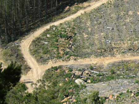
May 2004: High erosion potential noted at this culvert feeding into Stony Creek.
Hancock Watch Site Visit March 2002: Entered plantation from west came across plenty of recent logging. Saw evidence of broken culverts and very poor creek crossings along primary logging roads in Stony Creek catchment and on a tributary feeding into Matheisson Creek. It also looked like trail bike riders had been in the plantation, cutting up and degrading sensitive roading and drainage areas with their trail bikes. One location in the recently logged Mathieson Creek catchment had been used by locals as a rubbish dump. Any remedial work that Hancock had promised to the very dodgy road inside Stony Creek was completely unsatisfactory. The road appeared to still be in use and the off road vehicles were obviously 'joy riding' over the remedial barring. Any further sedimentation of King Parrot Creek could well spell the death sentence for the remnant population of Macquarie Perch that lie downstream. This is a very vulnerable catchment and utmost care needs to the taken by all land users. Sediment was observed at this location entering the creek system and a solution for this problem site needs to eventuate.
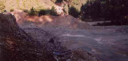
May 2004: Poorly located quarry in Stony Creek catchment.
Some photos from the March 2002 site visit can be seen at;
http://www.hancock.forests.org.au/docs/may02b.html#content_top
Hancock Watch Site Visit May 03: Most of the King Lake plantations located on the west side of Yea Road have not as yet been logged. However heavy logging has taken place in the main bulk of plantation located in the King Parrot Creek catchment on the east side of Yea Road. Most of the western aspect plantation has been clearfelled in the Stony Creek catchment. Logging in the Mathieson Creek catchment has been confined to the western side. Logging will be expected to go into the Mathieson and Pheasant Creek catchments later in the year. Many trailbike riders were seen in the plantation. Remedial work on the Stony Creek roading issue has been undertaken, but trailbike riders see the road barring as a challenge to ride over. Light rain was falling in the plantation and we witnessed many examples of poor drainage leading to increased sediment loads entering the waterways of Stony Creek and an unnamed tributary east of Stony Creek. Many deficient log trails had large puddles forming on them.
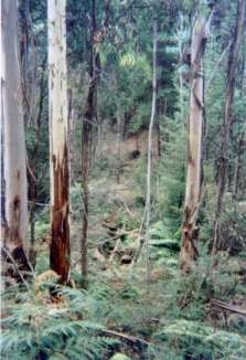
May 2003: Mathiesson Creek catchment buffer. Logging has taken place over much of the western portion of this plantation in the past 2 years. Loggers will now be targeting the Mathiesson and Pheasant Creek catchments.
King Parrot Creek: Medium to slow flowing in forest with open country downstream, gravel, rock and mud bed. Self-supporting trout population from spawning in the headwaters and recruitment from the Goulburn River. Contains mostly brown trout average 200g, maximum 900g, river blackfish to 120g, average 50g and some Macquarie perch average 320g, maximum 1.5kg with most fish 500-650g. Lower section near its junction with the Goulburn River fishes very well for trout when the Goulburn is high, cold and clear during irrigation water releases.
Source: A Guide to the Inland Angling Waters of Victoria by BR Tunbridge, PL Rogan, CA Barnham. Department Conservation and Environment. Arthur Rylah Institute for Environmental Research, 123 Brown St, Heidelberg, 3084. (4th ed - 1991)
 |
 |
 |
 |