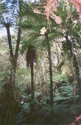
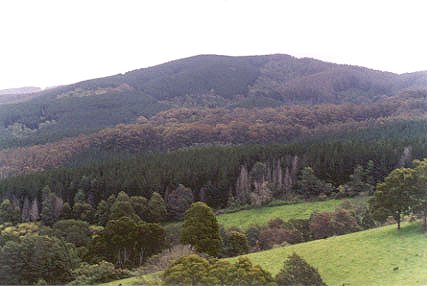
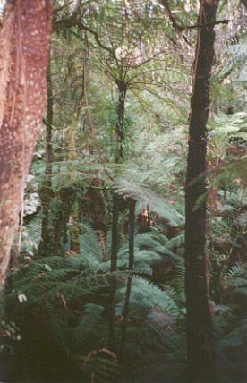
Region: StrzeleckisLegal Number: LEGL/93-92Plantation: JackConservation Priority: HighWater Catchment Area (LAND USE DETERMINATION -26/1/71): TARRA RIVER CATCHMENT SUPPLIES WATER FOR ALBERTON, PORT ALBERT, YARRAM. LUD’S REPLACED WITH SPECIAL AREA PLANS UNDER THE CATCHMENT AND LAND PROTECTION ACT 1994.Located in Yarram Water Supply Protection Area - GroundwaterAlso see: Yarram abnormalitiesArea within PaperlinX area of supply.Area within Planthard Hardwoods (Drouin West Sawmills) area of supply.Area within Brown and Dureau Softwoods (Morwell) area of supply.Strzelecki Ranges Maps HereTHREATENED FISH NOTES - STRZELECKI STREAMS: Habitat forSpotted Galaxias, Mountain Galaxias, Broadfinned Galaxias, Tupong , Blackfish and the FFG listed Australian Grayling..Responsible Authority: Wellington Shire Council/LaTrobe Shire Council? Plantation Catchment: Soils according to 1978 Geological Survey maps 1978; Kls: Cretaceous (Lower Aptian) Paludal - Strzelecki Group: Feldspathic, lithic sandstone, siltstone and mudstone, minor black coal, quartzose sandstone, conglomerate, local carbonate concentrations. Abundant plant remains. ‘A Report on the Tarra River Catchment (Yarram Waterworks Trust) 1970’ p6 “The catchment is situated on the southern slope of the South Gippsland Highlands with the off-take weir on the Tarra River about 9 miles NW of Yarram at R.L. 421 feet” . . . p11 “. . . From the weir the water travels through a nine mile long pipeline first to the service basin at Devon North, then on to the 150,000 gallons water tower in Yarram . . . the maintenance of a good summer flow is essential . . . p12 the rocky and boulder strewn stream bed keeps transported material in suspension. In the absence of a reservoir at the intake this has the detrimental effect on the nine mile pipeline . . . the occasional high turbidity readings are inescapable. . .” p10 “. . . The erosion hazard in the catchment is generally low. The soils are Jurassic sediments, which are the most common, have good structure and depth, and absorb moisture readily. This explains the absence of any form of erosion, excepting landslips. . . Landslides and slips happen during every above average wet winter. Most vulnerable to this type of erosion are the cleared, steep sided valleys and the high and steeply cut road batters . . .” "South Middle Creek rainforest South Middle Creek rainforest is bounded by the Grand Ridge Road to the north, Tarra Valley Road to the west and Whitelaws Track to the south and east. There is cool temperate rainforest along most of the length of South Middle Creek. The section without rainforest is that adjacent to plantation between Middle Creek and Middle Creek Track.
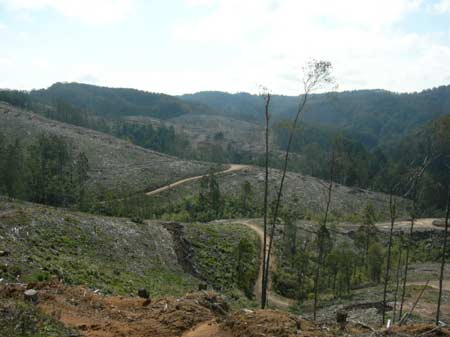
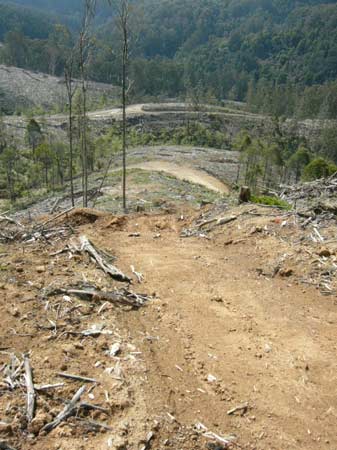
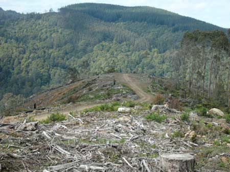
September 2009: Jack River Logging Dubois Track - Cores and Links Rainforest Reserve.
September 2009: Jack River Logging Dubois Track
September 2009: Jack River Logging Dubois Track |
Rough boundary map of plantation LEGL93-92, taking in much of the Jack River headwaters, South Middle Creek and some of the Albert River. Age dates of plantations/reforestation may differ slightly to those below due to plantings in different years being in close proximity to each other.
|
|||||||||||||||||||||||||||||||||||||||||||||||
|
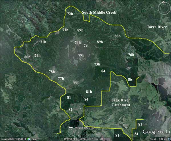
Jack River Catchment (between yellow lines) showing extent of plantations within catchment (numbers eg 76 refer to the year of plantation establishment). Approximately 1000ha appear to have occurred in 1976 (plantations within red line). Plantations established in 1980/1 (`~1000ha) were most likely established with a concoction of Amitrole (Weedagol T.L. Plus) and (Gesaprim 500) Atrazine may have been sprayed. In 2002 scientists in the United States found that Atrazine at levels as low of 0.1part per billion altered hormones in frogs. Since then Atrazine has been found to have the same effect across a range of animals. 1000ha would probably have been sprayed with the Atrazine (4 l/ha/Amitrole 7l/ha) mixture. Totals 4000 litres Atrazine, 7000 litres Amitrole). The highest risk years for drinking water quality would have been between 1974-8 & 1980-1. Prior to September 1976, it is highly likely that aerial application of 2,4,5-T @ 1.1 litres a hectare occurred. ~1000ha would have been aerially sprayed with 2,4,5-T in 1975 south of the Grand Ridge Road and west of Whitelaws Track. One could concur that ~1000ha of plantations in Jack River were aerially sprayed with 2,4,5-T in 1976. The areas marked in red show likely areas where 2,4,5-T would have been used. Total 2,4,5-T amount used 1971-1977 would have been 1100L mixed with 50,000 litres of diesel. How much of this ended up in the Jack River?
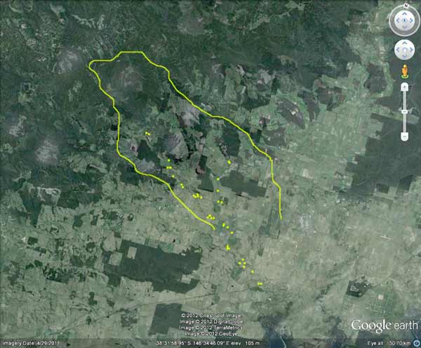
Rough map showing houses that may pump water directly from the JackRiver (area marked within yellow lines). Perhaps 40 houses could pump water from the Tarra River (80 people). All of these residences lie downstream of where 24,5,-T/Atrazine/Amitrole was sprayed, with the most pesticide loads likely for people south of Antonio Creek. Catchment Managment Authority: West Gippsland Catchment Management Authority www.hancock.forests.org.au/docs/jack.htm#content_top
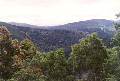
"Jack River Rainforest: Jack River rainforest is bounded by the Grand Ridge Road and Hour Track to the north, Jack Road to the east and south and the Yarram/Madalya Road to the west. There has been a lot less plantation activity on the tributary flowing south/west from Hour Track than the tributary west of Cockrem Track. The rainforest within the tributary south of Hour Track is a great deal wider and more dense than that on the western tributary. In a number of places the rainforest extends up spurs for more than 100 metres. This tributary is also an extremely rich site for slender and skirted tree ferns. However, tracks and plantation activities into the headwaters from Hour Track and Jack Track have resulted in erosion and blocked water flow on the eastern side of the headwaters. Most of the area surrounding the rainforest in this eastern tributary
is native vegetation consisting of Wet Scherophyll forest containing
large numbers of mature mountain ash and Blackwood forest. There are
some areas of Messmate forest on the eastern side of the tributary,
adjacent to Jack Track. In the northwest corner there has been some
attempt to establish mountain ash plantation, mainly from Cockrem Track,
but most of this is failed plantation and has reverted to native vegetation."
A number of sections of the rainforest on this creek are quite wide and extend more than 100 metres up the slope on the northern side. The southern side tends to be more damaged due to past clearing or plantation activity, but there are some wide sections of rainforest on that side as well.There are also extensive areas of blackwood forest, with some myrtle beech scattered within it. The major section of rainforest is in the north/west corner of the headwaters. There are many skirted and slender tree ferns in this section. There are a number of important habitat areas in the South Middle Creek Catchment. The major area of mountain ash regrowth is in the north/east corner, adjacent to the Tarra Valley Road. There is a small area of mountain ash regrowth and understorey vegetation on the steep slopes of the south east corner. There are large areas of blackwood forest north of the creek, below plantation and a small area of mountain ash regrowth in the northwest corner. There are fewer areas of regrowth in the southern side, but some small areas remain in the south-west section. As there are very few areas of mature eucalypts left in the Strzeleckis,
and the remaining few are rapidly disappearing, these areas of native
vegetation need to be preserved."
Map above indicates the extent of Hancock land from this plantation which lies within the Tarra River Proclaimed Water Catchment. For full details of all of Hancock land lieing within this catchment click here. Herbicides Used by Grand Ridge Plantations - Strzelecki Ranges and Gippsland Victoria
|
||||||||||||||||||||||||||||||||||||||||||||||||
|
Middle Creek, Boolara: A small stream, gravel bottom, joining the Morwell River below Boolara. Contains brown trout to 330g, average 160g, eels and small spiny freshwater crayfish. Not often fished. Morwell River, Morwell: Rises in mainly cleared hills, flows in a rock and mud bed through cleared river flats. Dense growth of willows on the banks below Boolara makes fishing difficult. Catchment is steep sided, and erosion has led to some of the middle and lower reaches becoming badly silted. A popular stream with local anglers. Some trout spawning occurs. Contains mainly brown trout to 560g, average is very small, also eels, spiny freshwater crayfish, carp, goldfish, tupong and river blackfish. Upper section particulary good for fly fishing. Jack River, Yarram: A tributary stream of the Albert River, fast flowing and running through partly cleared hills, rock bottom. Contains brown trout to 520g, average 160g, abundant mainly small river blackfish, tupong, both species of eels and grayling.
|
|
|||||||||||||||||||||||||||||||||||||||||||||||
|
Albert River - Below Staceys Bridge: Flows through open country, mud and sand bottom. Highly modified by agriculture, water is often turbid with wide variations in flow and water level. Where the habitat is suitable, trout will be found but, like the Agnes River, these areas are relatively inaccessible. Eels abundant and a few brown trout from 200 to 600g, occasional small river blackfish. Estuarine section often has estuary perch. Traralgon Creek, Traralgon: Small creek flowing through mostly cleared land, rock and mud bottom. Catchment modified for agriculture and the stream is at times turbid from erosion. The deeper holes are silting up. Contains mainly brown trout average 90g, maximum 600g, also eels, tupong, river blackfish, and freshwater crayfish. Creek now contains a healthy self-supporting population of small trout. Source: A Guide to the Inland Angling Waters of Victoria by BR Tunbridge, PL Rogan, CA Barnham. Department Conservation and Environment. Arthur Rylah Institute for Environmental Research, 123 Brown St, Heidelberg, 3084. (4th ed - 1991)
|
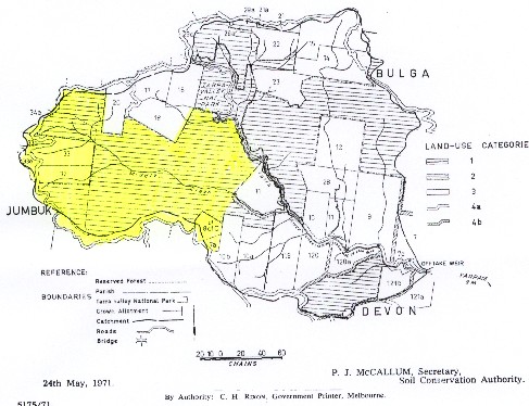
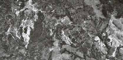
1972 aerial photograph of portion of this plantation. This shows the heavy activity within this catchment occurring mainly south of Whitelaws Track. The heavily disturbed land on left side of photo was replanted with hardwoods and pine from 1972 onwards. |