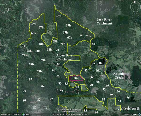
Region: StrzeleckisLegal Number:LEGL/93-89/1Plantation: AlbertConservation Priority:HighResponsible Authority:Wellington Shire Council Plantation Catchment: Also see: December 2003 Updates. Catchment Managment Authority: West Gippsland Catchment Management Authority. Located in Yarram Water Supply Protection Area - Groundwater Herbicide Regime (Incomplete); This plantation was very likely to be aerially sprayed with 2,4,5-T between 1968 and 1977. The Dioxin TCDD may still exist in soil in this plantation. For more historical data on 2,4,5-T click here. For more information concerning the continuing health crisis concerning 2,4,5-T please forward to here. Spring 2001: 608 kg of Velmac G and 798 kg of Velmac CR used on 74 ha to kill regenerating native forest. |
On 25 October 1995, Wellington Shire permitted Hancock to clear 80 ha of wattle regrowth for plantation establishment. This clearing occurred in allotment PT94B - Parish Binginwarri off Ward Road on the eastern side of the Albert River. Permit Number: WP9500347. DSE has also retained rights to harvest approximately 30-40ha of hardwood just north of Hiawatha.(see image below-area marked in purple). |
THREATENED FISH NOTES -STRZELECKI STREAMS:Habitat forSpotted Galaxias, Mountain Galaxias, Broadfinned Galaxias, Tupong , Blackfish and the FFG listed Australian Grayling.. www.hancock.forests.org.au/docs/albert.htm#content_topsee also Albert River Section 1-A |
||||||||||||||||||||||||||||||||||||||||||||||||
Area within PaperlinX area of supply.Herbicides Used by Grand Ridge Plantations - Strzelecki Ranges and Gippsland Victoria
|
||||||||||||||||||||||||||||||||||||||||||||||||||
|
||||||||||||||||||||||||||||||||||||||||||||||||||
|
|
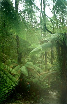
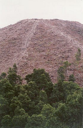
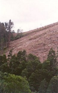
Site Visit December 01: Drove along Yarram Madalya Road. Entered northern section of plantation mass at Charcoal track. Recent logging had occurred in this area. One gully was observed having a track bulldozed through its headwaters, however the logging coupe at this location was generally of a high quality, as an area of messmate forest and mixed forest appeared to have been spared from logging. Much of this vegetation leads into buffer zones along the Albert River. The track appears to stop at a tributary of the Albert River where a slender tree fern was observed. Koalas were heard near this location and if the area is spared from logging by Hancock then a good result will eventuate. Entered plantation area near the junction of Yarram-Madalya Road and the Grand Ridge Road. At the junction of the most northerly tributary of the Albert River a myrtle beech tree was observed. This is located approximately 15 metres outside of the Hancock's LEGL boundary map. |
||||||||||||||||||||||||||||||||||||||||||||||||
|
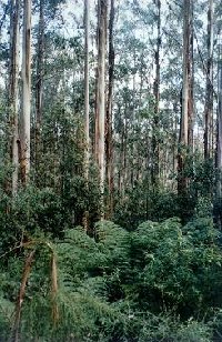
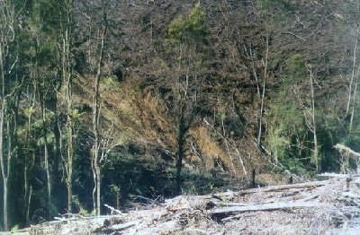
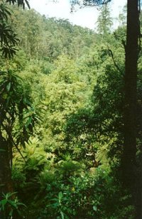
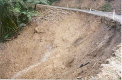
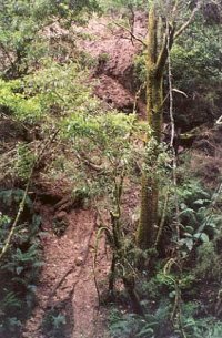
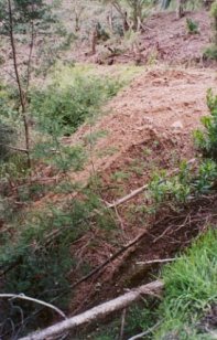
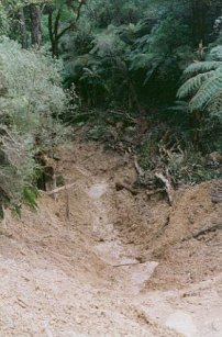
However Cool Temperate Rainforest dominates much of the Albert River for some distance. A track running alongside the eastern edge of the Albert River was followed over a couple of tributaries which also were dominated by Myrtle Beech. Logging by Hancock in 1999 of plantations established in the late 1960's have jeopardised the long term survival of much of the rainforest of the Albert River. Some older ash trees were observed on the western side of the Albert River, but it appears that much of this older forest has been terminated. About 2km from the turnoff to Yarram Madalya Road along the Grand Ridge Road heading west a large landslip has been created along one of the main tributary headwaters of the Albert River less than 30 metres from the Grand Ridge Road. | |||||||||||||||||||||||||||||||||||||||||||||||||
|
|
|
||||||||||||||||||||||||||||||||||||||||||||||||
|
For other logging photographs of this LEGL please go to the following links: http://www.hancock.forests.org.au/docs/logging_practices_8-02.htm http://www.hancock.forests.org.au/docs/may02b.html#content_top http://www.hancock.forests.org.au/docs/logging_practices_update-0101-02.htm "Albert River Rainforest: Albert River rainforest is bounded by the Grand Ridge Road to the north, the Yarram/Madalya Road to the east and Ward Road to the south. There is very little rainforest left on the Albert River. The best section of rainforest is on the section flowing south from the Grand Ridge Road parallel with the Yarram Madalya Road. Only scattered myrtle beech and tiny sections of rainforest remain on that section flowing south/east from Albert River Road. Logging operations were carried out in sections between the rainforest and the Yarram Madalya Road in late 1998 and early 1999. No buffer was left between the rainforest and the logging track and debris was pushed into the rainforest gully. Further logging operations are planned for this area in the near future. It is recommended that when these operations are conducted, a suitable buffer is left between clearing and tracks and the rainforest. Myrtle wilt is already apparent within this rainforest.
There are also sections of messmate forest and other
native vegetation between the rainforest and the Yarram Madalya Road
that need to be conserved." |
||||||||||||||||||||||||||||||||||||||||||||||||||
|
|
|
||||||||||||||||||||||||||||||||||||||||||||||||
|
Little Albert River, Staceys Bridge: A fast flowing stream running through partly cleared hills, rock bottom. Contains brown trout to 350g, average size very small, abundant small river blackfish, short finned eel, tupong and grayling. Albert River - Above Staceys Bridge: A fast flowing stream running through partly cleared hills, rock bottom. Contains brown trout to 350g, abundant, mainly small river blackfish, tupong and grayling. Albert River - Below Staceys Bridge: Flows through open country, mud and sand bottom. Highly modified by agriculture, water is often turbid with wide variations in flow and water level. Where the habitat is suitable, trout will be found but, like the Agnes River, these areas are relatively inaccessible. Eels abundant and a few brown trout from 200 to 600g, occasional small river blackfish. Estuarine section often has estuary perch. Source: A Guide to the Inland Angling Waters of Victoria by BR Tunbridge, PL Rogan, CA Barnham. Department Conservation and Environment. Arthur Rylah Institute for Environmental Research, 123 Brown St, Heidelberg, 3084. (4th ed - 1991) Albert River Section 1-A |
||||||||||||||||||||||||||||||||||||||||||||||||||