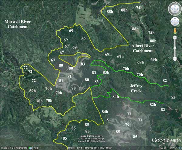
Region: StrzeleckisLegal Number: LEGL/93-88Plantation: AlbertConservation Priority: High |
||||||||||||||||||||||||||||||||||||||||||||||||||
|
|
|
||||||||||||||||||||||||||||||||||||||||||||||||
Area within PaperlinX area of supply.Area within Planthard Hardwoods (Drouin West Sawmills) area of supply.Area within Brown and Dureau Softwoods (Morwell) area of supply.Located in Yarram Water Supply Protection Area - Groundwater |
||||||||||||||||||||||||||||||||||||||||||||||||||
| Herbicide | Label Rate max as kg/ha | Used to control | Euc/Rad | Notes | Application |
| Clopyralid | 2.55 | Woody Weeds | Radiata and Eucalypts | Highly Toxic/Potential Ground water Contaminant | aerial or ground |
| Glufosinate Ammonium | 1 | Woody Weeds | Radiata | aerial or ground | |
| Glyphosate | 3.6 | Herbaceous and woody weeds, noxious weeds | Radiata, Eucalpts and Custodial | ||
| Haloxyfop-methyl | 0.13 | Annual and Pernneial Grasses | Eucalypts | Carcinogen | aerial or ground |
| Hexazinone | 4 | Woody Weeds | Radiata | Ground Water Contaminant | Aerial, ground, spot |
| Metsulfuron-Methyl | 0.06 | Woody Weeds, Noxious Weeds | Radiata, Eucalyptus and Custodial | Potential Ground Water Contaminant | Aerial, ground or spot |
| Sulfometuron Methyl | 0.6 | Annual and Perennial Grasses and broadleaf weeds | Eucalyptus | Potential Ground Water Contaminant | Aerial or Ground |
Hancock Site visit:
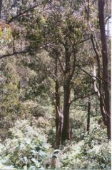
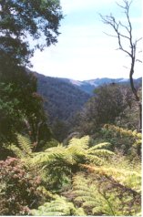
Large mass of 'plantation' approximately 4 1/2km x 6km in size. The 'plantation' takes in much of the headwaters of the Albert River, Jeffrey Creek as well as some of the headwaters of the Little Albert River. Site Visit: December 01: Entered area along Albert River Road. At McClean Road headed south along an area of remnant vegetation, including older ash trees, in the headwaters of the Jeffrey Creek. At one vantage point along this road a view was gained of the Jeffrey Creek catchment. Much of it appeared to be intact regenerating native vegetation, although probably a large proportion was young regeneration. Turned back onto Albert River Road and then headed east. It was apparent that much logging activity had been taken place in the northern portion of Albert River Road with many recent logging operations apparent. The southern side of the road consisted of the Jeffrey Creek of which it was difficult to assatain 1970 'plantation' from areas of regnerating native forest - although it could be said that much of the Jeffrey Creek headwaters is definately not plantation and is marked that way on LEGL maps. Much of the recent clearing of 1969 'plantation' to the north of Albert River Road appears to have left minimal buffer zones in many places. This is unsatisfactory and more width to buffer zones needs to be established throughout this area.
|
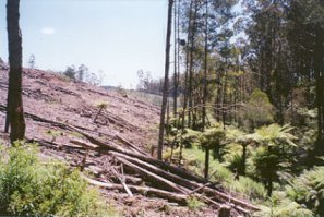
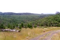
December 2001: Recently logged plantation near Livingston Track in Albert River catchment. |
|
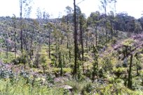
December 2001: Recently logged ash 'hardwood plantation' within Albert River catchment. Minimal buffer zones apparent at this location. |
THREATENED FISH NOTES - STRZELECKI STREAMS: Habitat forSpotted Galaxias, Mountain Galaxias, Broadfinned Galaxias, Tupong , Blackfish and the FFG listed Australian Grayling..
Responsible Authority: Wellington Shire Council
Plantation Catchment: Many Creeks HW Albert River
Several creeks HW Jeffrey Creek/Albert River
Catchment Managment Authority: West Gippsland Catchment Management Authority
Albert River - Above Staceys Bridge: A fast flowing stream running through partly cleared hills, rock bottom. Contains brown trout to 350g, abundant, mainly small river blackfish, tupong and grayling.
Albert River - Below Staceys Bridge: Flows through open country, mud and sand bottom. Highly modified by agriculture, water is often turbid with wide variations in flow and water level. Where the habitat is suitable, trout will be found but, like the Agnes River, these areas are relatively inaccessible. Eels abundant and a few brown trout from 200 to 600g, occasional small river blackfish. Estuarine section often has estuary perch.
Source: A Guide to the Inland Angling Waters of Victoria by BR Tunbridge, PL Rogan, CA Barnham. Department Conservation and Environment. Arthur Rylah Institute for Environmental Research, 123 Brown St, Heidelberg, 3084. (4th ed - 1991)
|
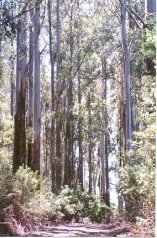
December 2001: Recently logged ash 'hardwood plantation' within Albert River catchment. Minimal buffer zones apparent at this location - although it could be worse! Further protection of the gully extending at least 20 metres at this site should have occurred. (The cleared forest has been replanted with non-endemic Shining Gum). |