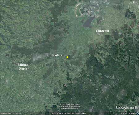
These plantations are located approximately 3km east of Boolara.
Two areas of plantation located in the Bellbook Creek catchment THOMSON/LATROBE RIVER: THOMSON/LATROBE RIVER: Australian Grayling are found in some streams in the catchment. Used to have a large population of Blackfish, but due to desnagging, sedimentation and destruction of riparian vegetation these populations have declined. Crayfish are an issue in catchment. Responsible Authority: LaTrobe Shire Council Plantation Catchment: HW 1 trib of Bellbrook Creek/Morwell River Catchment Managment Authority: West Gippsland Catchment Management Authority Herbicides Used by Grand Ridge Plantations - Strzelecki Ranges and Gippsland Victoria
Morwell River, Morwell: Rises in mainly cleared hills, flows in a rock and mud bed through cleared river flats. Dense growth of willows on the banks below Boolara makes fishing difficult. Catchment is steep sided, and erosion has led to some of the middle and lower reaches becoming badly silted. A popular stream with local anglers. Some trout spawning occurs. Contains mainly brown trout to 560g, average is very small, also eels, spiny freshwater crayfish, carp, goldfish, tupong and river blackfish. Source: A Guide to the Inland Angling Waters of Victoria by BR Tunbridge, PL Rogan, CA Barnham. Department Conservation and Environment. Arthur Rylah Institute for Environmental Research, 123 Brown St, Heidelberg, 3084. (4th ed - 1991) Hancock Watch Site visit December 2001:
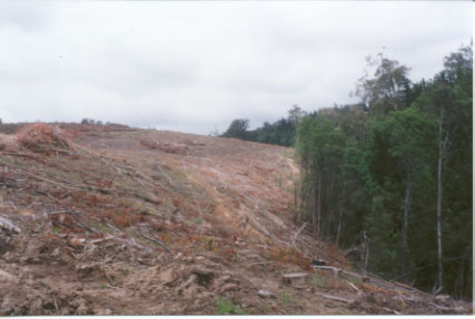
Plantation is in two parts and is located about 3-5km east of the town of Boolara. Recently cleared plantation on east side located on very mild slopes on what was probably ex-farmland. Some buffer retained along Bellbrook Creek. Plantation cleared within 5 months. Some older trees left along roadside strip along Mill Road but this buffer was quite small. Some drainage lines appeared to be replanted with pine. Did not check out separate plantation on west side. A portion of this plantation appears to take in some of Bellbrook Creek, further inspection warranted.
Feb 1967 aerial photo (top=north). Part of this plantation (top left hand corner of photo was already established with pine. The main bulk of this future plantation however was native forest which was probably cleared by the State Government in the late 1970's (bottom right half of photo).The Mill Road can quite clearly be seen on bottom right of photo. |

.jpg)