Declared Water Catchment Area: Approximately 80% of this plantation lies within Tarwin River (Meeniyan) Water Supply Catchment. PROCLAIMED 24/4/90.
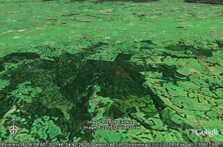
Google Earth image circa early 2001: Childers plantation marked by red dot. Declared Water Catchment: The north east portion of the plantation lies in the Narracan Creek Water Supply Catchment. This catchment supplies water to Moe, Trafalgar and Westbury. Proclaimed 7/1/81.
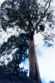
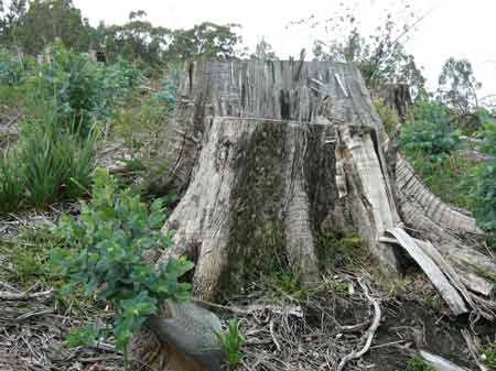
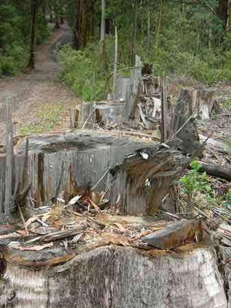
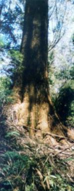
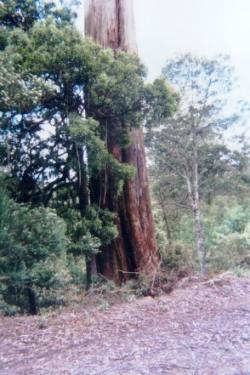
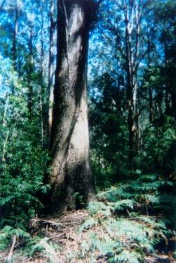
Old growth converted to Shining gum plantation in late 2007. This tree had a base of 6-7 metres round before it was logged in Hancock. Close to ten very old trees were logged from this site with a couple of hectares of 50 year old ash also logged.
This plantation was very likely to be aerially sprayed with 2,4,5-T between 1968 and 1977. The Dioxin TCDD may still exist in soil in this plantation. For more historical data on 2,4,5-T click here. For more information concerning the continuing health crisis concerning 2,4,5-T please forward to here. Area within PaperlinX area of supply.Area within Planthard Hardwoods (Drouin West Sawmills) area of supply.Area within Brown and Dureau Softwoods (Morwell) area of supply.THREATENED FISH NOTES - TARWIN RIVER: Consistent records of Australian Grayling.
Responsible Authority: Baw Baw Shire Council
Herbicides Used by Grand Ridge Plantations - Strzelecki Ranges and Gippsland Victoria
Jan 01: Drove back into area. Appears to be remnant vegetation remaining in headwaters of Watkins Creek which hasn't been logged, but could not adequately assess area due to height of regrowth. Creek crossing at Watkins Creek along Black Water Hole Track is collapsing. Also drove into pine plantation along Logging Track to try to get access to Head Waters of Watkins Creek. No access possible. Hancock Watch Site Visit Dec 00: b) Drove to southern portion of 1977 pine plantation. Drove along Childers Settlement Road. Drove down Possum Track. Logging looks like it occurred 1 year ago. Vigorous regen too thick to walk through. Noted tops of old growth eucs near gully line. Could not assatain whether old trees had been taken. Steep logging tracks in places. Took water sample from dam covered in green algae further up the road. Drove along Loop Road in northern aspect of plantation. Dominated by 1946 Ash 'regrowth' in pretty good shape. Not known when logging will take place but area looked quite intact with good understorey. Southern part of Loop Road dominated by pine plantations. Roads average. Hancock Watch Site visit Jan 01: c) Drove passed turn off of Childers Settlement Road along Childers Road away from Allambee. Old eucalyptus species along roadside on both sides of road for a portion of Hancock holdings on Childers Road. These trees were much older than 1980/81 plantations as marked on LEGL plans. Also drove down Fowkes Road. Older gully vegetation including blackwoods and ferns in gully as well as old ash species - older than 1980/83 regrowth as indicated on Hancock maps. Trees on roadside and down top end of gully along Childers Road were much older than trees marked as 1946 plantation in Headwaters of Elizabeth Creek as witnessed in December down Loop Road. ‘A report on the Narracan Creek Catchment 1980 - Soil Conservation Authority’ “. . . Moe Waterworks Trust diverts water from Narracan Creek to supply the townships of Moe and Westbury . . . Approximately 8ML of water per day is gravitated to the treatment plant from the offtake . . . Since 1946, the Trafalgar Waterworks Trust has diverted water from Narracan Creek, through a 200mm pipeline which discharges into the HW of Sunny Creek. The rate of discharge is over 1.5ML per day. . . p3 The raw water is often high in colour, turbidity and conductivity . . . p8 an area of about 63 ha in the Strzelecki part of the catchment in the NW is also public land and is leased to APM for pine plantations . . . p10 fertilisers, herbicides and persticides probably contribute to the pollution of water in streams, but no data is available to indicate the extent of that contamination . . .” Tarwin River West Branch - upstream from Allambee South: Flows through scrub covered hills, rock and gravel bed. Access restriced by private property. Self sustaining for trout in the top section. Contains predominately brown trout to 460g, average 90g, some river blackfish particularly in the tribuataries and tupong. Watkins Creek, Allambee South: Flows through scrub covered hills, rock and gravel bed. Access restricted by private property. Self-sustaining for trout in the top section. Contains predominately brown trout average 150g, maximum 600g, numerous river blackfish and grayling. Elizabeth Creek, Allambee South: Flows through scrub covered hills, rock and gravel bed. Access restricted by private property. Contains predominately brown trout to 350g, average 100g, some river blackfish and tupong. Narracan Creek, Moe: Small mud and gravel-bottomed stream flowing from open hilly country to open river flats. Catchment has been modified by agriculture, stream is turbid and in many places choked with willows. Contains a few brown trout average 350g, also eels, small river blackfish and sping freshwater crayfish. Fished mainly above Moe. Source: A Guide to the Inland Angling Waters of Victoria by BR Tunbridge, PL Rogan, CA Barnham. Department Conservation and Environment. Arthur Rylah Institute for Environmental Research, 123 Brown St, Heidelberg, 3084. (4th ed - 1991)
|