Declared Water Catchment Area: APPROXIMATELY 80% OF THESE PLANTATIONS LIES WITHIN TARWIN RIVER (MEENIYAN) WATER SUPPLY CATCHMENT. PROCLAIMED 24/4/90.
Rough map of 4 seperate plantation/native forest sites and approximate years when plantations were established. Note almost 500ha planted between 1980-84 would have been established with Atrazine @ 4L/ha and Amitrole @ 7L/ha. Meaning 2000L of Atrazine and 3500L of Amitrole sprayed into Deadlock Creek catchment between 1980-84.
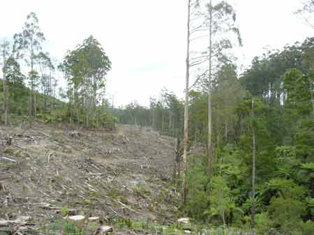
December 2007. This hardwood coupe gets the chop in the headwaters of the Tarwin River West Branch Area within PaperlinX area of supply.Area within Planthard Hardwoods (Drouin West Sawmills) area of supply.Area within Brown and Dureau Softwoods (Morwell) area of supply.THREATENED FISH NOTES - TARWIN RIVER: Consistent records of Australian Grayling. Herbicides Used by Grand Ridge Plantations - Strzelecki Ranges and Gippsland Victoria
Responsible Authority: Baw Baw Shire Council
Plantation Catchment: Catchment Managment Authority: West Gippsland Catchment Management Authority
Hancock Watch Site Visit Dec 00. Notes on Filmy Maidenhair found in this plantation on Deadlock Creek. (The largest colony of the fern, with an area of around 3.0 m2, is situated within the Allambee Plantation, Mt Worth Block, an area managed by Hancock Victorian Plantations. The surrounding streamside vegetation is currently protected by Regional prescriptions and the Code of Forest Practices 1989, which excludes timber extraction operations from streamside buffers and steep slopes. The streamside vegetation along Deadlock Creek, part of the system of corridors of native forest within the surrounding plantation, protects an undisturbed deep gully supporting a rich fern flora. Twenty-four different fern species have been noted growing near the colony (DCE, Central Gippsland) including Slender Tree-fern (Cyathea cunninghamii), classed as a rare species in Victoria (Gullan et al. 1990)).
March 2006: Deadlock Creek looking west over the plantation's east side. Site visit 29/12/00 to eastern plantation. Walked down Russell Road -off Leongatha - Yarragon Road. Walked 2km's to trib of Deadlock Creek. Recent dozer activity. Road went adjacent to and through gully. Young pines growing in gully. Saw 2 yellow-tail black cockatoos feeding off and chewing pine cones. Recent pine establishment probably less than a year old. Very steep slopes in places in places. Moe River, Moe: A large drain 10-15m wide flowing through open country, mud and gravel bottom. Some deep pools. Very fertile water carrying predominately carp average 1kg, maximum 3kg, and eels. Tarwin River West Branch - upstream from Allambee South: Flows through scrub covered hills, rock and gravel bed. Access restriced by private property. Self sustaining for trout in the top section. Contains predominately brown trout to 460g, average 90g, some river blackfish particularly in the tribuataries and tupong. Watkins Creek, Allambee South: Flows through scrub covered hills, rock and gravel bed. Access restricted by private property. Self-sustaining for trout in the top section. Contains predominately brown trout average 150g, maximum 600g, numerous river blackfish and grayling.
Source: A Guide to the Inland Angling Waters of Victoria by BR Tunbridge, PL Rogan, CA Barnham. Department Conservation and Environment. Arthur Rylah Institute for Environmental Research, 123 Brown St, Heidelberg, 3084. (4th ed - 1991)
|