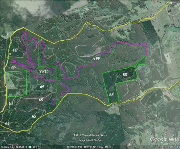
Headwater image of Bruthen Creek, showing extent of Hancock's land holdings. Hancock purchased approximately 400ha of the headwaters of Bruthen Creek in 1998 (marked on map VPC) and followed that with the purchase of an additional 700ha in 2001 with the purchase of Australian Paper Plantations. Plantations were established by the Forests Commission in the catchment between 1964-66 and 1988. The 1964-66 plantations are now in their second rotation. The Hancock controlled area contains ~300ha of native forest, including old growth forest.
Herbicides used during the eighties may have included Amitrole/Atrazine for grasses, Lontrel L (3,6-DCPA), hexazinone, glyphosate, triclopyr. Current herbicides used by Hancock (see below).
Herbicides in bluegum plantations are generally used only in the first two years. Common herbicides used in bluegum plantations include: Glyphosate, Metsulfuron Methyl*, Sulfometuron Methyl*, Simazine*, Amitrole*, Clopyralid*, Oxyfluorfen*, Haloxyfop, Terbacil* and Metosulam. Common herbicides used in radiata pine plantations include; Glyphosate, Hexazinone*, Metsulfuron Methyl*, Sulfometuron Methyl*, Haloxyfop, Carfentrazone-ethyl, Glufosinate ammonium, Triclopyr and Clopyralid*. Fertilisers, adjuvants and anti-antagonists are also used by plantation companies. (*Residual in aerobic or anaerobic soils for longer than 100 days). In terms of human health the underlined pesticides are of most concern. In new plantations, trees can be established right up to existing drainage lines, increasing the likelihood of pesticide runoff into waterways during rainfall.
Herbicides Used by Grand Ridge Plantations - Strzelecki Ranges and Gippsland Victoria
| Herbicide | Label Rate max as kg/ha | Used to control | Euc/Rad | Notes | Application |
| Clopyralid | 2.55 | Woody Weeds | Radiata and Eucalypts | Highly Toxic/Potential Ground water Contaminant | aerial or ground |
| Glufosinate Ammonium | 1 | Woody Weeds | Radiata | aerial or ground | |
| Glyphosate | 3.6 | Herbaceous and woody weeds, noxious weeds | Radiata, Eucalpts and Custodial | ||
| Haloxyfop-methyl | 0.13 | Annual and Pernneial Grasses | Eucalypts | Carcinogen | aerial or ground |
| Hexazinone | 4 | Woody Weeds | Radiata | Ground Water Contaminant | Aerial, ground, spot |
| Metsulfuron-Methyl | 0.06 | Woody Weeds, Noxious Weeds | Radiata, Eucalyptus and Custodial | Potential Ground Water Contaminant | Aerial, ground or spot |
| Sulfometuron Methyl | 0.6 | Annual and Perennial Grasses and broadleaf weeds | Eucalyptus | Potential Ground Water Contaminant | Aerial or Ground |
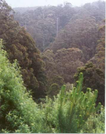
October 2001: Non-plantation ash species and native forest within supposed plantation holding. Most of this area was logged in 2003.
Hancock Watch site visit October 01: This so-called plantation actually consists of 4 separate areas with quite a large distance seperating the plantations. One pine plantation is located on flat slopes in the Reedy Creek Catchment about 2kms north west of Carrajung Lower. This plantation is of low conservation importance. A second plantation located on Bruthen Creek about 4kms south of Carrajung has not been visited. A northern portion of the Bodman Creek headwaters is also located on this plantation map. Some of the Bodman catchment appears to have been logged in the recent past, probably by the Victorian Plantation Corporation - but the rest of the catchment remains of high conservation quality.
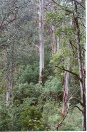
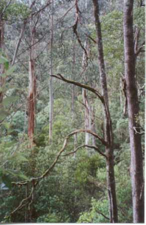
The most substantial plantation area abuts the Grand Ridge Road on the southern side between Blackwarry and Carrajung. It stretches for about 3km with pine plantations dominating the south. The area appears to be of no consequence situated on flat land which was probably cleared 100 years ago. However the eastern top half of the plantation is dominated by native forest. Entry into this area can be gained from Fergusons Road which runs in close proximity to the headwaters of the Bruthen Creek. The upper tributaries of Bruthen Creek are surrounded by plantations and farmland, however a few hundred metres from the Grand Ridge Road, Bruthen Creek is located in a deep gully with possibly 80 year Blackwoods and similar aged Mountain ash, tree ferns and silver wattle. It has a definite rainforest quality although it appears that Myrtle Beech is not present in Bruthen Creek. (Also very old and large examples of Blanket Leaf were seen at this high quality area). On the north eastern side of Bruthen Creek there are old growth Mountain Ash seen from Fergusons Road. Access to younger Mountain Ash (supposed non-plantation) is gained from Willis Road. This is a high quality area with old growth located in this area further to the south. This area must not be logged.
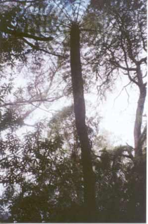
Hancock Watch site visit October 01: Ferguson Road was followed for several kms. The first km is quite a stunning walk. Access into the Bruthen Creek was made via an old plantation track. Inside the buffer zone were old ash and what possibly were blue gums. There was also found a population of enourmous slender tree ferns - at least 30 feet high and probably hundreds of years old. Some nice views into the old growth on the north eastern slopes were evident from this access point. Further down Ferguson Road the dominance of plantations is evident with a couple of main tributaries being somewhat degraded.
Hancock Watch site visit November 01: Quite a substantial amount of native vegetation is evident in the Bodman Creek catchment in the south of this plantation. It appears that Victorian Plantation Corporation most likely cleared quite a substantial part of this catchment as the area has prolific regeneration of ash species. This area in question is not marked as plantation on the LEGL maps meaning that the area was logged in the past few years. This is a shame as the Bodman Creek catchment would have been dominated by naturally regenerating messamate and mountain ash, however quite a substantial amount of this forest remains - especially along the creek itself and the eastern end of the catchment.
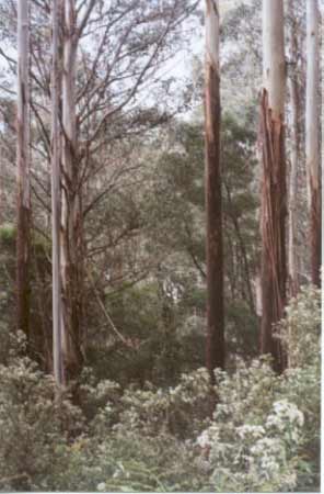
October 2001: Old growth inside Bruthen Creek catchment just off Fergusons Road.
Plantation Catchment:
a) Reedy Creek + 1 creek/Bruthen Creek
b) 1 HW trib Bruthen Creek
c) Several HW Bruthen Creek
d) 1 trib Bruthen Creek-Borders Bruthen Creek
October 2001: Remnant native vegetation (and old growth) within plantation holding on eastern slopes of Bruthen Creek on Ferguson Road.
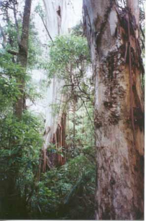
October 2001: Remnant native vegetation within plantation holding near Bruthen Creek.
.jpg)
Above: 1966 photo of Blackwarry showing that the land where this plantation was established was primarily cleared farmland. Grand Ridge Road running through near middle of photo, with Carrajung Lower Road at the bottom of the photo. Ferguson Road can be seen to the right of the photo which clearly shows retained native vegetation at the top (eastern) portion of road. To the left of Grand Ridge Road is a portion of plantation LEGL93-106 with native vegetation retained in Sassafras Creek catchment (top left of photo).
.jpg)
1972 photo showing plantation establishment well under way on both sides of Grand Ridge Road. The small area of native bush on ferguson Road can still clearly be seen.
Reedy Creek, Carrajung South: A fast flowing water with good pools, gravel bed. Access restriced by private property and difficult terrain. Contains predominately brown trout and some rainbow trout, both species averaging 200g, some fish to 450g, and eels.
Bruthen Creek, Carrajung South - Above Reedy Creek: A fast flowing water with good pools, gravel bed. Access restricted by private property and difficult terrain. Contains predominately brown trout and some rainbow trout, both species averaging 200g, some fish to 450g and eels.
Bruthen Creek - Below Reedy Creek: Very shallow, mud and sand bottom. Very few fish taken and not recommended an an angling water. Source: A Guide to the Inland Angling Waters of Victoria by BR Tunbridge, PL Rogan, CA Barnham. Department Conservation and Environment. Arthur Rylah Institute for Environmental Research, 123 Brown St, Heidelberg, 3084. (4th ed - 1991).