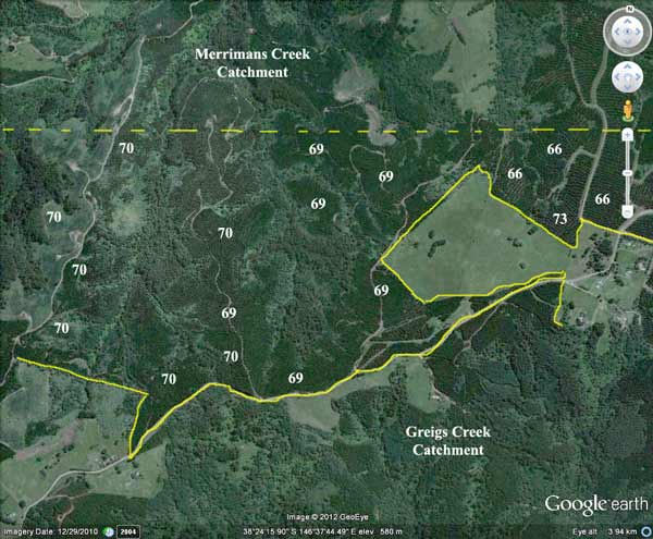
Plantation LEGL93-108 (between yellow lines), headwaters of Merrimans Creek, showing extent of plantations within catchment (numbers eg 76 refer to the year of plantation establishment).
Most (approximately 150ha) appear to have occurred between 1966-1973. It is highly likely thereforethat aerial application of 2,4,5-T @ 1.1 litres a hectare occurred. ~150ha would have been aerially sprayed with 2,4,5-T . Total amount used 1966-73 would have been 165L mixed with 7,500 litres of diesel. How much of this ended up in Merrimans Creek? How high was the dioxin content of the 2,4,5-T during the 1960's? Residents at Blackwarry, may have been exposed to spray drift.
Herbicide Regime (From incomplete information supplied by Gippsland Water)
This plantation was very likely to be aerially sprayed with 2,4,5-T between 1966 and 1973. The Dioxin TCDD may still exist in soil in this plantation. For more historical data on 2,4,5-T click here. For more information concerning the continuing health crisis concerning 2,4,5-T please forward to here.
April 2000: 120 ha sprayed with 417.6kg Trounce (glyphosate and metsulfuron methyl) to kill Blackberry and Silver Wattle.
October 2000: About 154.2 ha sprayed with 2929.8kg of Velmac G to kill silver wattle.
Herbicides Used by Grand Ridge Plantations - Strzelecki Ranges and Gippsland Victoria
| Herbicide | Label Rate max as kg/ha | Used to control | Euc/Rad | Notes | Application |
| Clopyralid | 2.55 | Woody Weeds | Radiata and Eucalypts | Highly Toxic/Potential Ground water Contaminant | aerial or ground |
| Glufosinate Ammonium | 1 | Woody Weeds | Radiata | aerial or ground | |
| Glyphosate | 3.6 | Herbaceous and woody weeds, noxious weeds | Radiata, Eucalpts and Custodial | ||
| Haloxyfop-methyl | 0.13 | Annual and Pernneial Grasses | Eucalypts | Carcinogen | aerial or ground |
| Hexazinone | 4 | Woody Weeds | Radiata | Ground Water Contaminant | Aerial, ground, spot |
| Metsulfuron-Methyl | 0.06 | Woody Weeds, Noxious Weeds | Radiata, Eucalyptus and Custodial | Potential Ground Water Contaminant | Aerial, ground or spot |
| Sulfometuron Methyl | 0.6 | Annual and Perennial Grasses and broadleaf weeds | Eucalyptus | Potential Ground Water Contaminant | Aerial or Ground |
Soils according to 1978 Carrajung Geological Survey Map:
Kls: Cretaceous (Lower Aptian) Paludal - Strzelecki Group: Feldspathic, lithic sandstone, siltstone and mudstone, minor black coal, quartzose sandstone, conglomerate, local carbonate concentrations. Abundant plant remains.
Tvo: Palaeocene/Eocene: Dense augite and olivine basalt, tuff, claystone and siltstone. Often extremely weathered and ferruginized.
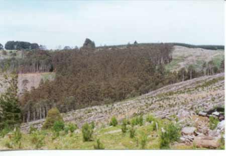
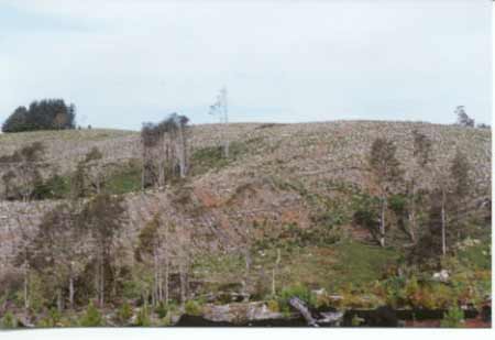
Hancock Watch Site visit October 01: Plantation located due west of Blackwarry on the south face of the Grand Ridge Road. The headwaters of a couple of tributaries feeding into Merrimans Creek are in this plantation. Buffer zones on these tributaries appear to be minimal although there is some native vegetation about one km north of the headwaters. Took photos from Grand Ridge Road looking north into pine plantation. Buffer zones appeared to be minimal in places. Tribs of Merrimans Creek require greater protection. Drove down Youngs Road through recently established pine plantations. Plantations here were established in 1969/70 and appear to have been logged about one year ago. Fairly flat topography. Some regnerating Blackwood slopes but very small in size. Also drove some way down Comming Road. Minimal buffer zones on some of the tributaries of Merrimans Creek
October 2001: Recent pine logging in tributaries of Merrimans Creek. Note lack of buffers.
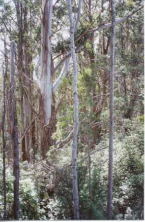
Merrimans Creek, Gormandale: The estuary contains bream, sea mullet, estuary perch, luderick and yellow-eye mullet. "Rainforest Merrimans Creek: The section of rainforest at Merrimans Creek does not extend very far down the creek but is very wide, extending high up the slope on the eastern side. There is also a very small section of old growth on the eastern edge of the rainforest. The western side of the creek was cleared for plantation purposes in late 1998 and no buffer was left for the rainforest." Rainforests in the Strzeleckis by Elaina Fraser.
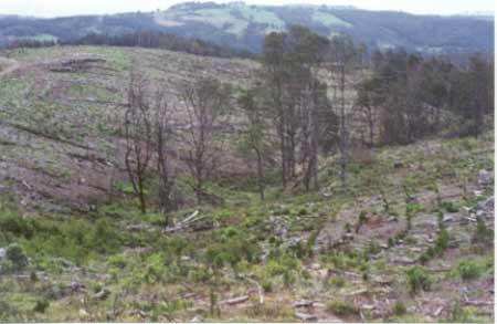
October 2001: Buffer inside Merrimans Creek catchment.