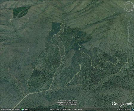
Region: OvensLegal Number: LEGL/93-155Plantation: Copper CreekConservation Priority: MediumPlantation within Australian Newsprint Mill (ANM) Ltd area of supply. Plantation within Carter Holt Harvey (now owned by International Paper) area of supply. Plantation within Dominance Industries (Alpine MDF Industries) area of supply. Plantation within D & R Henderson/Monsbent area of supply.
Cropper Creek image circa 2004. The bushfires of February 2009 burnt out this plantation. North East Victoria Plantation Map here Site of Cropper Creek hydrological study see here Feb 2011: Huge Sediment loads (up to 31.1 tonnes/ha post plantation salvage logging "Post-fire and harvesting water quality impacts were greatest during storm events. Sediment and nutrient yields from the burnt and harvested pine catchment greatly exceeded those from the burnt native forest catchments. The largest increases in yields were for sediment (33 and 180 times the yields from the two burnt native forest catchments) and particulate phosphorous (20 and 78 times). However, figures for increases in sediment yield from the pine catchment are conservative because large quantities of bedload material exported from the catchment could not be measured. The increase in sediment yield from the pine catchment was probably closer to 71 and 320 times yields from the two burnt native forest catchments. These estimates are based on a survey of eroded channels in the pine catchment combined with measurement of the post-survey sediment output Including the measured bedload, the total sediment yield following wildfire and harvesting from Clem increases to 31.1 t ha -1"
Proclaimed Water Catchment Area: This plantation area is located in the Buffalo River (Lake Buffalo) Water Supply Catchment. Herbicides Used by Hancock in Pine Plantations - North East Region Victoria
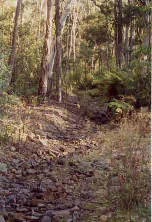
Near the headwaters of Cropper Creek. Looking south. OVENS RIVER SUPPLIES WANGARATTA WITH WATER. MURRAY RIVER SUPPLIES WATER
TO YARRAWONGA, COBRAM, BARMAH, ECHUCA , KERANG, PIANGIL, SWAN HILL,
ROBINVALE, MILDURA A Report on the Buffalo River - 1984. Soil Conservation Authority. "Lake Buffalo construction was completed in 1965. It is used for irrigation. p3 Soils: predominantly hilly and mountainous area of Ordovician mudstones, shales and sandstones, with massive granitic intrusions at Abbeyard, Mt Emu and principally Mt Buffalo . . . p8 Erosion from disturbed sites in or close to streams and the removal of ground-cover over extensive areas by wildfire are the greatest potential hazards to water quality. Some disturbances may arise through farming activities, clearing, or forest operations (roading, logging)...” “Special Investigation: North-Eastern Victoria - Ovens Softwood Plantation Zone. Land Conservation Council 1981. p11 Central Region To the north and east of the Eastern Boundary Fault lies an extensive area of mountainous terrain composed of Ordovician sandstones and mudstones that are less resistant to erosion than the rocks of the south-western region. The drainage pattern is dendritic and the streams are seperated by sharp ridges and spurs. The mountains to the south of Mount Buffalo are typical of this region, which extends east to Mount Beauty and north to Myrtleford. In the north-west around Moyhu and Bobinalwarral the ridges of Ordovician sediments become buried beneath the alluvial deposits of the riverine plain. Within the region, exposures of granitic rocks have intruded into the surrounding Ordovician sediments. Intense heat associated with the intrusions has altered (or metamorphosed) the adjacent sedimentary rocks. The granite outcrops at Mount Buffalo and Mount Emu are extremely resistant, while the surrounding sedimentary rocks which are less resistant have been deeply dissected. In contrast, the granite in the Pinnacles area to the east of Myrtleford
is more susceptible to weathering and erosion and as a consequence the
terrain in this area is more subdued. A ridge of metamorphic rocks borders
Happy Valley to the east of Myrtleford. Friable reddish and brownish
gradational soils occur on the Ordovician sediments of this region,
while the granitic rocks of Buffalo Plateau and Mount Emu exhibit a
variety of soil types. Stony loams are characteristic of rocky outcrops
while poorly drained sites contain organic loams and peats. Sandy loams
and friable gradational soils are found on the lower slopes of these
intrusions. The less resistant granitic rocks at the Pinnacles and Abbeyard
carry a variety of gradational soils on the upper slopes and a range
of duplex soils at lower elevations. The gradational soils are suitable
for softwoods, but the poorly drained duplex soils are not. |