Region: Ovens

Legal Number: LEGL/93-153/1

Plantation: Cropper Creek

Conservation Priority: High

Plantation where the Secretary CNR retains specified rights to harvest hardwood sawlogs.

Plantation within Australian Newsprint Mill (ANM) Ltd area of supply.

Plantation within Carter Holt Harvey (now owned by International Paper) area of supply.


93-153d March 01: Native vegetation vested to Hancock within Bread and Butter Creek catchment.

Plantation within Dominance Industries (Alpine MDF Industries) area of supply.

Plantation within D & R Henderson/Monsbent area of supply.

Proclaimed Water Catchment Area: This plantation area is located in the Buffalo River (Lake Buffalo) Water Supply Catchment.

North East Victoria Plantation Map here

Herbicides Used by Hancock in Pine Plantations - North East Region Victoria

Herbicide Label Rate max as kg/ha Used to control Notes Application
Carfentrazone-Ethyl 0.036      
Clopyralid 2.55 Woody Weeds Highly Toxic/Potential Ground water Contaminant air or ground
Glyphosate 3.6 Herbaceous and woody weeds, noxious weeds    
Hexazinone 4 Woody Weeds Ground Water Contaminant Aerial, ground, spot
Metsulfuron-Methyl 0.06 Woody Weeds, Noxious Weeds Potential Ground Water Contaminant Aerial, ground or spot
Triclopyr 3 Woody and Noxious Weeds   Ground, spot, basal bark


OVENS RIVER SUPPLIES WANGARATTA WITH WATER. MURRAY RIVER SUPPLIES WATER TO YARRAWONGA, COBRAM, BARMAH, ECHUCA , KERANG, PIANGIL, SWAN HILL, ROBINVALE, MILDURA

THREATENED FISH NOTES - OVENS RIVER: Most important river in Victoria in regard to the survival of the Murray Cod. Murray Cod spawn almost as far up as Myrtleford and the Ovens supplies recruitment for the Murray River as well. The Ovens has no dams and is a river of extreme national significance. Trout Cod are now being found in the Ovens and may set up a self sustaining spawning population. Trout Cod have been successfully stocked into Ovens and upper Ovens, downstream of Myrtleford and going up the King River - past Moyhu. All the tribs of the Ovens are important for native fish including King, Buffalo and Buckland Rivers.

Responsible Authority: Alpine Shire Council

Plantation Catchment: Many creeks Cropper Creek/Lake Buffalo/Buffalo River/Ovens River. Many tributaries and headwaters of Bread and Butter Creek/Cropper Creek/Lake Buffalo. Tribuaties of Lake Buffalo.

LEGL93-153: Likely DNRE concession 
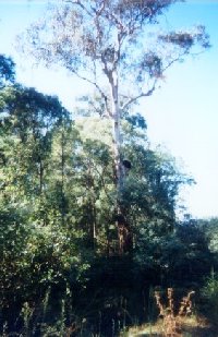
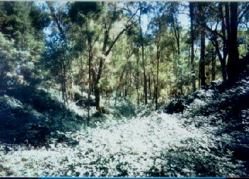
zone within Hancock plantation boundary. Impressive quality native vegetation on the west side of Lake Buffalo.

Catchment Managment Authority: North East Catchment Management Authority.

Hancock Watch site visit Mar 01: Very difficult to get proper reading of maps due to variance in maps. However it can be said that this plantation does have extensive buffer zones inside the plantation, especially along Bread and Butter creek which drains into Cropper Creek. Some of the area also has some problems with blackberrys. Did not come across too much harvesting of plantations on this trip.

Other Notes A Report on the Buffalo River - 1984. Soil Conservation Authority:

Lake Buffalo construction was completed in 1965. It is used for irrigation. p3 Soils: predominantly hilly and mountainous area of Ordovician mudstones, shales and sandstones, with massive granitic intrusions at Abbeyard, Mt Emu and principally Mt Buffalo . . . p8 Erosion from disturbed sites in or close to streams and the removal of ground-cover over extensive areas by wildfire are the greatest potential hazards to water quality. Some disturbances may arise through farming activities, clearing, or forest operations (roading, logging)...”

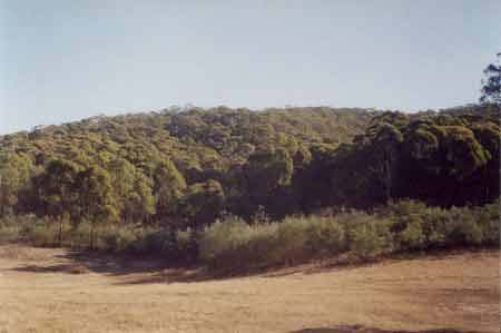
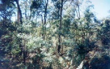
LEGL93-153: View of plantation from Carboor Road. Ridge at top of photo is State Forest and is to the east of Mount Emu.

“Special Investigation: North-Eastern Victoria - Ovens Softwood Plantation Zone. Land Conservation Council 1981.

p11 Central Region To the north and east of the Eastern Boundary Fault lies an extenisive area of mountainous terrain composed of Ordovician sandstones and mudstones that are less resistant to erosion than the rocks of the south-western region. The drainage pattern is dendritic and the streams are seperated by sharp ridges and spurs. The mountains to the south of Mount Buffalo are typical of this region, which extends east to Mount Beauty and north to Myrtleford.

In the north-west around Moyhu and Bobinalwarral the ridges of Ordovician sediments become buried beneath the alluvial deposits of the riverine plain. Within the region, exposures of granitic rocks have intruded into the surrounding Ordovician sediments. Intense heat associated with the intrusions has altered (or metamorphosed) the adjacent sedimentary rocks. The granite outcrops at Mount Buffalo and Mount Emu are extremely resistant, while the surrounding sedimentary rocks which are less resistant have been deeply dissected.

In contrast, the granite in the Pinnacles area to the east of Myrtleford is more susceptible to weathering and erosion and as a consequence the terrain in this area is more subdued. A ridge of metamorphic rocks borders Happy Valley to the east of Myrtleford. Friable reddish and brownish gradational soils occur on the Ordovician sediments of this region, while the granitic rocks of Buffalo Plateau and Mount Emu exhibit a variety of soil types. Stony loams are characteristic of rocky outcrops while poorly drained sites contain organic loams and peats. Sandy loams and friable gradational soils are found on the lower slopes of these intrusions. The less resistant granitic rocks at the Pinnacles and Abbeyard carry a variety of gradational soils on the upper slopes and a range of duplex soils at lower elevations. The gradational soils are suitable for softwoods, but the poorly drained duplex soils are not.

Ovens River: The rivers all flow north, from heavily forested mountain country through excessive river flats to the Murray River. Murray cod populations close to the Murray River. Small river blackfish are common in many rivers, Macquarie Perch are still occasionally caught, and catches of golden perch are also being reported. Brown trout widely distributed through system with rainbow trout most abundant in upper reaches.

Buffalo Lake - Dandongadale: A deep water storage surrounded by cleared land. A poor producer of trout for some unknown reason. Adult Macquarie Perch translocated in 1981 and 1991 to bolster the remnant population in the lake. Wide fluctuations in water level. Contains some brown trout to 2kg and rainbow trout to 550g, also abundant redfin, some to 1.7kg, goldfish and some Macquarie Perch. Also possibly an occasional Murray Cod. Trout spawn in the Buffalo River above the lake.

Source: A Guide to the Inland Angling Waters of Victoria by BR Tunbridge, PL Rogan, CA Barnham. Department Conservation and Environment. Arthur Rylah Institute for Environmental Research, 123 Brown St, Heidelberg, 3084. (4th ed - 1991)


93-153b March 01: Native vegetation within plantation along Carboor Road in the Bread and Butter Creek catchment.

93-153f March 01: Blackberry infestation of gully in the Bread and Butter Creek catchment..

93-153g March 01: More native vegetation inside plantation in the Bread and Butter Creek catchment.


More Pictures

HOME

Australian Newsprint Mill International Paper Buffalo Lake Dangonadale Ovens River Murray River Murray Cod Golden Perch Redfin Blackfish High Ovens (North East)