Region: OvensLegal Number: LEGL/93-150Plantation: Hurdle CreekConservation Priority: HighPlantation within Australian Newsprint Mill (ANM) Ltd area of supply. Plantation within Carter Holt Harvey (now owned by International Paper) area of supply. Plantation within Dominance Industries (Alpine MDF Industries) area of supply. Plantation within D & R Henderson/Monsbent area of supply. First plantation in Victoria to trial use of Hexazinone in 1978 Proclaimed Water Catchment Area: This plantation area is located in the Ovens River (Wangaratta) Water Supply Catchment. North East Victoria Plantation Map here
Feb 03: Recent clearfell logging in the Mayday Creek catchment. This photo taken on Hoffman Road. Extensive clearfelling has recently taken place in this plantation. MURRAY RIVER SUPPLIES WATER TO YARRAWONGA, COBRAM, BARMAH, ECHUCA , KERANG, PIANGIL, SWAN HILL, ROBINVALE, MILDURA Incomplete Herbicide Regime: This plantation was aerially sprayed with 2,4,5-T between 1968 and 1977. The Dioxin TCDD may still exist in soil in this plantation. For more historical data on 2,4,5-T click here. For more information concerning the continuing health crisis concerning 2,4,5-T please forward to here. July 1977: 162 ha sprayed with mixture of 1.4 litre a.i. butyl ester of 2,4,5-T in 48.6 litres of distallate per hectare in a portion of the plantation that drains into Scrubby Creek by Forest Commission. 2,4,5-T concentrations were below detection limit (0.3ug/l) in water in Scrubby Creek and in water from storages on private property. 2,4,5-T concentrations of up to 4.2ug/l were detected in a culvert pipe draining the main gully of the spray area on the 3rd, 4th and 5th day following spraying. (see 2,4,5-T Concentrations in Scrubby Creek Following Aerial Spraying of a young pinus radiata plantation - RJ McKimm & P Hopmans. Research Branch Report No. 93 Forests Commission 1977) Pesticides Review Committee Meeting #144 15/12/78. Letter sent from Forests Commission Victoria. "Approval sought to conduct aerial spraying to evaluate effectiveness of Velpar (active ingredient Hexazinone) for controlling woody weeds such as wattles and eucalypts in newly established pine plantations. The experiment is to be conducted in co-operation with DuPont (Australia) in the Myrtleford Forest District during mid November 1978... Water for domestic use is irregularly pumped from Emu Creek approximately 2.5km below the spray area..." Herbicides Used by Hancock in Pine Plantations - North East Region Victoria
Responsible Authority: Wangaratta Shire Council/Alpine Shire
Council
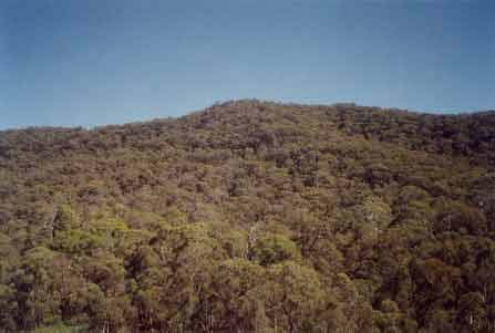
April 2003: A large area within
this plantation has been retained as native vegetation. This hill between
Emu Creek and Mayday Creek is within Hancock's holdings and has been
retained by the company. This segment of native vegetation extends over
5km's in a northerly direction and provides a wildlife link up the catchment
to State Forest in the Mount Emu area. Hancock Watch Visit Feb 03: Extensive plantation area extending 5km east to west and 4km north to south. We only scouted a small portion of the plantation. It would appear that this area could have an extensive area of native vegetation within its boundaries on the western slopes of Mayday Creek and the eastern slopes of Emu Creek. This area could extend to up to 4 km in length (north to south) and up to 500 hectares in size. Further scouting work at this plantation is warranted.
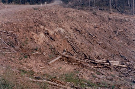
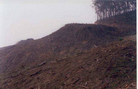
Feb 03: Recent clearfell plantation logging in the Hurdle Creek catchment. This area had decent enough buffers just outside this photo, but the headwaters were left relatively unprotected. �Special Investigation: North-Eastern Victoria - Ovens Softwood Plantation Zone. Land Conservation Council 1981. p11 Central Region To the north and east of the Eastern Boundary Fault lies an extenisive area of mountainous terrain composed of Ordovician sandstones and mudstones that are less resistant to erosion than the rocks of the south-western region. The drainage pattern is dendritic and the streams are seperated by sharp ridges and spurs. The mountains to the south of Mount Buffalo are typical of this region, which extends east to Mount Beauty and north to Myrtleford. In the north-west around Moyhu and Bobinalwarral the ridges of Ordovician sediments become buried beneath the alluvial deposits of the riverine plain. Within the region, exposures of granitic rocks have intruded into the surrounding Ordovician sediments. Intense heat associated with the intrusions has altered (or metamorphosed) the adjacent sedimentary rocks. The granite outcrops at Mount Buffalo and Mount Emu are extremely resistant, while the surrounding sedimentary rocks which are less resistant have been deeply dissected. In contrast, the granite in the Pinnacles area to the east of Myrtleford is more susceptible to weathering and erosion and as a consequence the terrain in this area is more subdued. A ridge of metamorphic rocks borders Happy Valley to the east of Myrtleford. Friable reddish and brownish gradational soils occur on the Ordovician sediments of this region, while the granitic rocks of Buffalo Plateau and Mount Emu exhibit a variety of soil types. Stony loams are characteristic of rocky outcrops while poorly drained sites contain organic loams and peats. Sandy loams and friable gradational soils are found on the lower slopes of these intrusions. The less resistant granitic rocks at the Pinnacles and Abbeyard carry a variety of gradational soils on the upper slopes and a range of duplex soils at lower elevations. The gradational soils are suitable for softwoods, but the poorly drained duplex soils are not.
Ovens River: The rivers all flow north, from heavily forested mountain country through excessive river flats to the Murray River. Murray cod populations close to the Murray River. Small river blackfish are common in many rivers, Macquarie Perch are still occasionally caught, and catches of golden perch are also being reported. Brown trout widely distributed through system with rainbow trout most abundant in upper reaches.
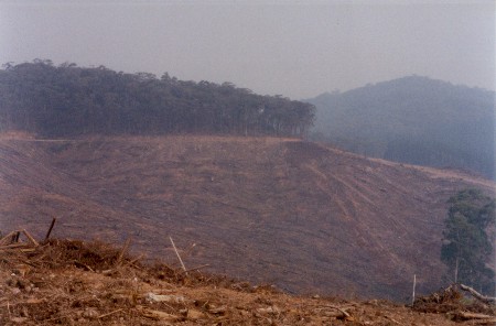
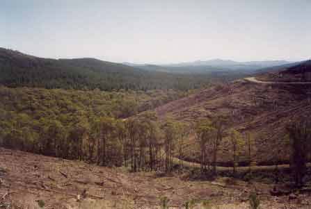
LEGL93-150: Photo looking north west down the Mayday Creek catchment. Large scale clearfell logging of plantations has recently occurred in this plantation.
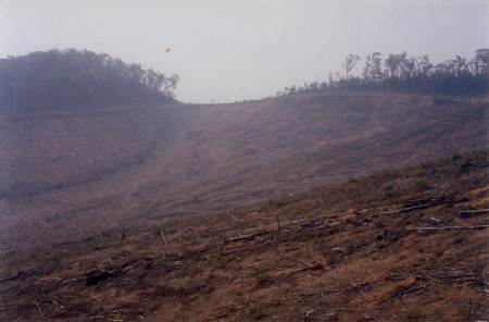
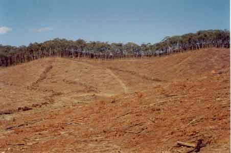
April 2003: Recent clearfell
logging in the headwaters of the Hurdle Creek catchment. Whole catchments
have been clearfelled in a relatively short space of time. |