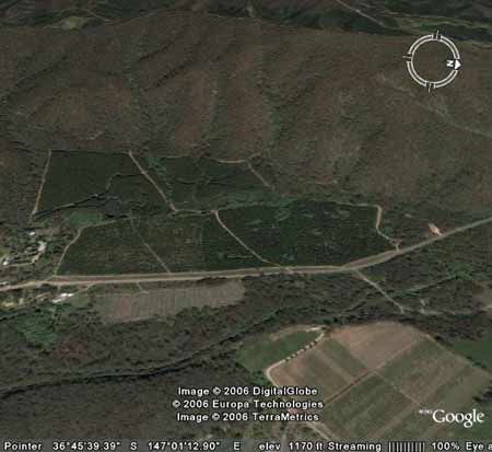
Region: OvensLegal Number: LEGL/93-133/1Plantation: FreeburghConservation Priority: Low |
| Herbicide | Label Rate max as kg/ha | Used to control | Notes | Application |
| Carfentrazone-Ethyl | 0.036 | |||
| Clopyralid | 2.55 | Woody Weeds | Highly Toxic/Potential Ground water Contaminant | air or ground |
| Glyphosate | 3.6 | Herbaceous and woody weeds, noxious weeds | ||
| Hexazinone | 4 | Woody Weeds | Ground Water Contaminant | Aerial, ground, spot |
| Metsulfuron-Methyl | 0.06 | Woody Weeds, Noxious Weeds | Potential Ground Water Contaminant | Aerial, ground or spot |
| Triclopyr | 3 | Woody and Noxious Weeds | Ground, spot, basal bark |
|
OVENS RIVER CATCHMENT SUPPLIES WANGARATTA AND BRIGHT WITH WATER. MURRAY
RIVER SUPPLIES WATER TO YARRAWONGA, COBRAM, BARMAH, ECHUCA , KERANG,
PIANGIL, SWAN HILL, ROBINVALE, MILDURA
THREATENED FISH NOTES - OVENS RIVER: Most important river in
Victoria in regard to the survival of the Murray
Cod. Murray
Cod spawn almost as far up as Myrtleford
and the Ovens supplies recruitment for the Murray River as well. The
Ovens has no dams and is a river of extreme national significance. Trout
Cod are now being found in the Ovens
and may set up a self sustaining spawning population. Trout
Cod have been successfully stocked into
Ovens and upper Ovens, downstream of Myrtleford and going up the King
River - past Moyhu. All the tribs of the Ovens are important for native
fish including King, Buffalo and Buckland Rivers.
Responsible Authority: Alpine Shire Council
Plantation Catchment: Several small creeks entering Ovens River
Catchment Managment Authority: North East Catchment Management
Authority
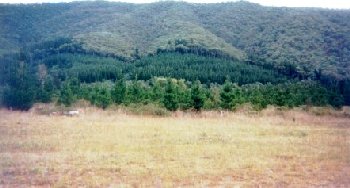
Hancock Watch site visit Mar 01: Plantation on mild slopes in
Ovens Valley. No logging appeared to be occurring. Some evidence of
pine wildings occurring up the slopes of this plantation.
‘A Report on the Ovens River (Bright) Water Supply Catchment - Soil Conservation Authority 1984’
p3 “The Ovens River catchment point at Bright covers an area of 350km2 and lies to the south-east of the town. . . Bakers Gully, a proclaimed catchment, lies to the south of Bright but is not contiguous with the Ovens River (Bright) Catchment. . . The original Bright town water supply was provided from two reservoirs in Bakers Gully, the lower constructed in 1900 and the higher in 1912. A pump on the Ovens River and rising main connecting into the town distribution system was installed in the early 1960’s, to both offset and decrease in effective storage capacity in the Bakers Gully storages which had occurred through silting, and to satisy the demand due to increases in the permanent and tourists peak populations of the town. The pumping facility at the offtake was subsequently expanded and is currently the sole source of water supply for the town. . . Although the greater part of the catchment is forested, from Harrietville the river passes through residential areas, cultivated crops, grazing land and pine plantations before reaching the offtake site within Bright township . . .
p4 . . . Dissolved salt, colour and turbidity values are low to very low. Quality overall is good for a river with a multiple-use catchment. The water supply is chlorinated at the pumping station . . . Mean annual rainfall for Bright is 1103mm and increases to more than 2000mm, due to the influence of elevation and topography, as one ascends the catchment. During winter months most of the catchment with elevations above 1500m receives its precipitation as snow and, in a normal winter, snow accumulates from June to September. High intensity storms are of short duration and occur mainly in summer. . .
p5 . . . The river valley below Harrietville is mature, surrounded by a hilly and mountainous area of Ordovician mudstones, shales and sandstones, with Quaternary deposits of gravel and alluvium on the valley floor. The area shows mature dissection with long, sharp ridges. The streams have a dendritic drainage pattern. Hillwash deposits (colluvium) and stream alluvium have been extensively distrurbed by gold-dredging . . . Friable brown and red gradational soils are present on the Ordovician sediments. On the steep slopes and northern aspects, the soils are commonly red and stony red gradational types with shallow profiles - often skeletal . . .
On the colluvium and alluvium which is found mostly along watercourses a number of different soils are found. Predominant soils are the red duplex types, friable gradational types and weakly bleached red-brown and yellow gradational soils. The past operation of floating dredges in the Ovens Valley as far as Harrietville has resulted in a re-sorting of alluvium obtained from depths as great as 25 m and more below the surface, and the deposition of stones and cobbles at the surface . . . Much of the land on the valley floor between Harrietville and Bright has been cleared and sown to pasture. The extensive dredged areas have, in the vicinity of Bright and Freeburgh, been planted to softwoods and elsewhere restored where possible . . . In the northern portion of the catchment some of the foothill country has been used to grow softwoods. . .
p6 . . . Mining has played an important part in the history of the area. Gold was first discovered at Harrietville in 1852, with quartz reef mining commencing in the 1860’s. The operation of floating dredges in the valley was extensive and continued at Harrietville and Freeburgh until the 1940’s . . . p7 . . . Erosion from disturbed sites in or close to streams and the removal of ground-cover over extensive areas by wildfire are the greatest potential hazards to water quality. Disturbances may arise through farming activities, clearing, or forest operations (roading, logging).
Turbidity and sedimentation of the water is not currently a problem, however, the impacts of disturbance being relatively short-lived . . . No camping is permitted in the Forests Commission (now Hancock) pine plantations near Bright between 15 November and 30 April as a fire protection measure, with the additional benefit of reducing human impacts on water quality. The Bright Waterworks Trust prohibits camping in the immediate vicinity of the offtake at all times . . .”
“Special Investigation: North-Eastern Victoria - Ovens Softwood Plantation Zone. Land Conservation Council 1981.
p12 The northern plains region
The north-west of the study area towards Wangaratta
contains part of the extensive riverine plains. The plains, which border
the major streams such as the King and Ovens Rivers and their tributaries,
consist of alluvial deposits, often more than 50m deep. Alluvial fans
occur along the foothill margins, and features such as river terraces
and ox-bow lakes, typical of a riverine flood plain occur along the
major river valleys. The river terraces are characterised by uniform
sandy loams and gradational soils, while the alluvial sediments of the
fllod plain are duplex soils, usually consisting of a sandy loam overlying
a clay subsoil. These soils are found in all major river valleys throughout
the study area. . .”
Ovens River: The rivers all flow north, from heavily forested mountain
country through excessive river flats to the Murray River. Murray cod
populations close to the Murray River. Small river blackfish are common
in many rivers, Macquarie Perch are still occasionally caught, and catches
of golden perch are also being reported. Brown trout widely distributed
through system with rainbow trout most abundant in upper reaches. Upstream
from Myrtleford - Brown Trout to 1.3kg, some rainbow trout, small redfin
and river blackfish.
Ovens River: Upstream from Myrtleford - Brown Trout to 1.3kg, some rainbow
trout, small redfin and river blackfish. Source: A Guide to the Inland
Angling Waters of Victoria by BR Tunbridge, PL Rogan, CA Barnham. Department
Conservation and Environment. Arthur Rylah Institute for Environmental
Research, 123 Brown St, Heidelberg, 3084. (4th ed - 1991)
HOME