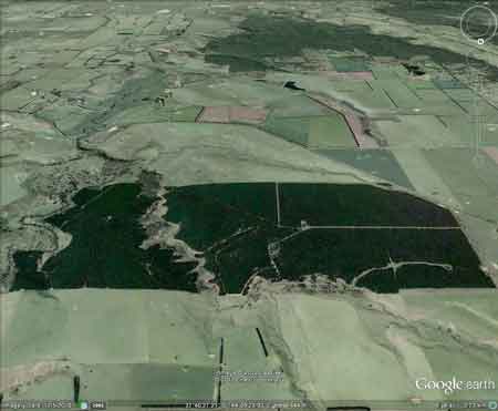
Plantation within AKD Softwoods area of supply. Plantation within SPE Exports (Geelong) area of supply.
Geelong residents as of March 2012 currently pay $1981.7 for a Megalitre of drinking water. This plantation would probably consume between 9 ML of water per hectare per year (2700ML/yr). This would equate to $5.35million worth of drinking water per year. Click here for map of Hancocks' Ballarat region plantations. Declared Water Catchment: Plantation lies within Moorabool River (Sheoaks) Catchment. Proclaimed 24/5/78. Water Supply For Geelong.Click here for map of Ballarat/Corangamite region water supply catchments.Herbicides Used by Hancock in Pine Plantations - Ballarat Region Victoria
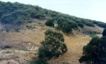
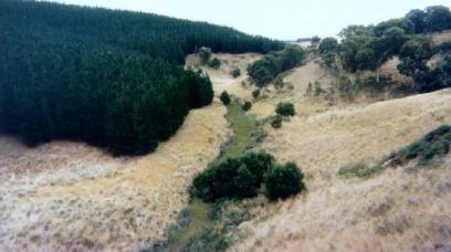
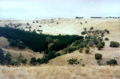
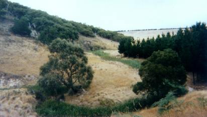
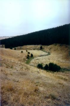
Water Catchment Area: MOORABOOL RIVER CATCHMENT - POTENTIAL DRINKING WATER FOR BANNOCKBURN, GHERINGHAP, LETHBRIDGE, MEREDITH & INVERLEIGH.THREATENED FISH NOTES - MOORABOOL RIVER: Good Blackfish population with Australian Grayling in the lower reaches. Responsible Authority: Moorabool Shire Council Plantation Catchment: Eastern edge borders Moorabool River East Branch (Downstream of Bostok Reservoir). Creek feeding into Moorabool flows through plantation. Catchment Managment Authority: Corangamite Catchment Management Authority Hancock Watch Site visit Feb 01: Quite a vast plantation lieing in a east west direction, surrounded by cleared farmland. Eastern edge lies up to Moorobool River East Branch. Most of the plantation (established in the 1980's) is pine located on mild slopes. Quite a significant area of native vegetation runs through the plantation about 2/3rds of the way from the western edge. This native vegetation runs along the banks of the Blair Creek which is a tributory of the Moorobool River East Branch. Some of this vegetation was regenerating and formed forest cover on the eastern slopes leading into Blair Creek. Pine largely covered the western slopes of Blair Creek and is established in places quite close to that Creek. On the southern end of Blair Creek the land was quite steep and rocky probably stopping the land being converted to pines. In regards to the Moorobool River East Branch, plantations have been established quite close to the Moorobool - however it was also evident that remnant vegetation was left on the banks of the Moorobool in many places and in other places NW corner a steep gorge protected the Moorobool East from plantations and the area had been fenced off. This native vegetation is important as there seems to be little native vegetation in the vacinity of the area - all native vegetation needs to be protected. PROCLAMATION OF THE MOORABOOL (SHEOAKS) WATER SUPPLY CATCHMENT. Soil Conservation Authroity 1978. �p3 In the early 1960�s the Geelong Waterworks and Sewerage Trust requested that the catchments to Korweinguboora and Bostok Reservoirs be proclaimed as water supply catchments . . . Catchment Description (a) General: The catchment area to the offtake weir at Sheoaks is approximately 460km2 and runs from the Great Dividing Range to within 25 km of Geelong. The catchment is approximately 50km long and 10 km wide and runs North - South . . . (b) Geology: In the north part of the catchment, the predominant rock types are Ordovician sandstone, mudstone and siltstones, with a couple of volcanic flows down old river beds. Twin stream development can be seen along these southerly moving flows. The central part of the catchment and along the Eastern edge are dominated by Quaternary basalt flows from some half dozen volcanic cones. Tertiary sands and gravels are the main feature in the South of the catchment, but also occur in the centre and along the western boundary . . . (c) Physiography: The Great Dividing Range in the North part of the catchment reaches an elevation of over 800m above sea level, and the area to the north of the Western Hwy is dominated by the foothills below the Range. South of the highway, there is mainly a basalt plain at about 500 m elevation, often with twin stream development deeply dissecting the underlying Ordovician or Tertiary sediments . . . (d) Climate: Rainfall varies from 1000mm in the north to 600 mm in the south. Average summer rainfall varies from 140mm to 105 mm, and average winter rainfall varies from 300mm to 150 mm . . . Average annual evaporation would be approximately 1100mm. Winds are predominantly from west to north west . . . Soils and Vegetation . . . both grey duplex and red gradational soils are found on the basalt material, gradational red and yellow soil are found on Tertiary sands and gravels . . . It is sufficient to note that most of the original vegetation has been removed from the basalt plains, but not from the Ordovician sediments or Tertiary deposits. Recent large scale clearing of the mixed species forest on the Northern Ordovician sediments has taken place for softwood conversion. Land Use Most of the northern part of the catchment is Reserved Forest, particularly on the Ordovician sediments . . . Hazards to the Water Supply The erosion hazard in the catchment is fairly low, but areas of steep Ordovician sediments, basalt escarpments, and steeper Tertiary derived soils should be protected from intensive development . . . overclearing has led to increasing salinity within the catchment and forest management (particularly softwood conversion) needs to be more strictly controlled . . ." East Branch Moorabool River: Bolwarrah to junction of East and West Branches. Flows through grazing land and carries brown trout to 1.3kg, redfin to 220g, tench and river blackfish. Source: A Guide to the Inland Angling Waters of Victoria by BR Tunbridge, PL Rogan, CA Barnham. Department Conservation and Environment. Arthur Rylah Institute for Environmental Research, 123 Brown St, Heidelberg, 3084. (4th ed - 1991)
|