Region: Ballarat
Legal Number: LEGL/93-41
Plantation: Glen Park
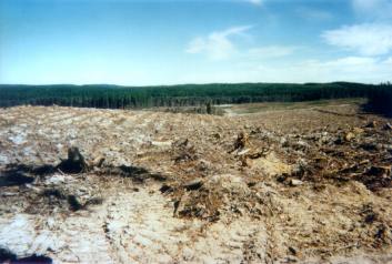
 93-41d: Feb
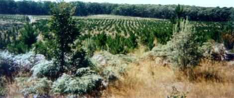
01 Newly planted area in headwaters of Murray Darling Basin. Young
growing trees use plenty of water. It has been estimated that pine
plantations use about 2ML (2 million litres) of water per hectare
per year, more than if that land was retained as pasture. Hancock
are not paying for the water that their trees draw upon. This subsidy
would be worth millions of dollars each year.
93-41d: Feb
01 Newly planted area in headwaters of Murray Darling Basin. Young
growing trees use plenty of water. It has been estimated that pine
plantations use about 2ML (2 million litres) of water per hectare
per year, more than if that land was retained as pasture. Hancock
are not paying for the water that their trees draw upon. This subsidy
would be worth millions of dollars each year. |
Conservation Priority: High
Plantation within AKD Softwoods area of supply.
Plantation within SPE Exports (Geelong) area of supply.

Approximate size of this plantation is 700ha and
is located 9km north east of the city of Ballarat. A portion of it lies
in the catchment of White Swan Reservoir.
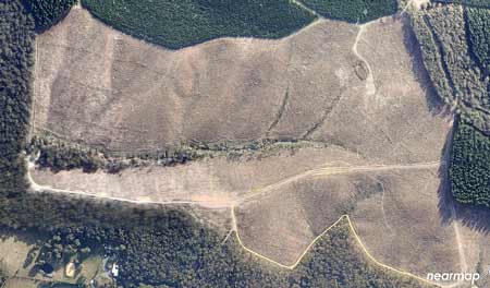
Early 2012: Large clearfelling continues. Many
trees in this drainage line appear to have blown over post logging.
Image Source Nearmap
Click
here for map of Hancocks' Ballarat region
plantations.
This plantation was very likely to be aerially
sprayed with 2,4,5-T between 1968 and 1977. The Dioxin TCDD may still
exist in soil in this plantation. For more historical data on 2,4,5-T
click
here. For more information concerning the
continuing health crisis concerning 2,4,5-T please forward to
here.
Herbicides Used by Hancock
in Pine Plantations - Ballarat Region Victoria
| Herbicide |
Label Rate max as kg/ha |
Used to control |
Notes |
Application |
| Clopyralid |
2.55 |
Woody Weeds |
Highly Toxic/Potential Ground water Contaminant |
air or ground |
| Glufosinate
Ammonium |
1 |
Woody Weeds |
|
|
| Glyphosate |
3.6 |
Herbaceous and woody weeds, noxious weeds |
|
|
| Hexazinone |
4 |
Woody Weeds |
Ground Water Contaminant |
Aerial, ground, spot |
| Metsulfuron-Methyl |
0.06 |
Woody Weeds, Noxious Weeds |
Potential Ground Water Contaminant |
Aerial, ground or spot |
| Triclopyr |
3 |
Woody and Noxious Weeds |
|
Ground, spot, basal bark |
Plantation where the Secretary CNR retains specified rights to harvest
hardwood sawlogs.
April 04: Anderson Gully in the
Tullaroop Proclaimed Water Catchment. Massive clearfell extending for
several kilometres.
Declared Water Catchment Area:
Southern most plantation (Glen Park) lies in close proximity (<1km)
to White Swan Reservoir within the Ballarat Water Supply Catchment.
(The Ballarat catchment boundary runs through the western half of the
plantation. Ballarat catchment proclaimed 19/12/79).
Click
here for map of Ballarat/Corangamite region
water supply catchments.
Declared Water Catchment Area:
Almost the entire plantation (bar the far western portion - near Waubra
Junction and the southern most plantation (Glen Park)) lies within the
Tullaroop Reservoir Catchment. Tullaroop Water Catchment Proclaimed
4/6/80. Numerous Headwater creeks of Tullaroop Reservoir lie in this
plantation which is situated in the Murray-Darling Basin. Tullaroop
Reservoir supplies irrigation water to northern Victoria and domestic
water to the City of Maryborough and the surrounding area including
Adelaide Lead, Alma, Havelock, Majorca and Betley.
Click
here for map of North Central Water Supply
Catchments
January 2003: Plantation within
Ballarat's water supply just upstream from the White Swan Reservoir.
THREATENED FISH NOTES - LODDON RIVER: Tullaroop Creek is a
good Blackfish
water. Slaty Creek and Creswick Creek have popluations of Mountain
Galaxias. The lower reaches
of the Loddon also provide good habitat for Murray
Cod and Yellow
Belly.
Responsible Authority: Ballarat City Council
Plantation Catchment: Sawpit Creek, Petticoat Creek, Mopoke
Creek/Crewick/Creswick Creek/Clunes/Tullaroop Creek/Tullaroop Reservoir.
Plus HW of some gullys flowing west to Burumbeet Creek/Lake Burumbeet
(These gullys include Bullock, Gloucester, Larkins, Brittania and Green
(Leak?) Gully. HW one creek flowing into Slattery Creek/Creswick Creek
etc.
Soils: Sourced from Geological Maps of Victoria
Ocl: Ordovician (Lancefieldian): Deep marine
deposits, metasandstone, grey and black slate, dominantly sand-rich
turbidite facies; moderately to well sorted, variably rounded quartz
with minor feldspar and lithic grains in Quartz silt or clay matrix
. . .
Qp: Neogene/Quaternary: Dissected colluvial,
alluvial and swamp deposits; occurs in headwaters of streams disrupted
by Newer Volcanics, gravel, sand, silt and clay, containing clasts of
sandstone, slate and vein quartz from bedrock or granite sand from granite;
generally poorly sorted and subangular; moderately to well consolidated;
ferruginized in part.
Qrc: Recent: Colluvial deposits; common around
hill bases and in gullies; polymictic gravel, sand, silt and clay; poorly
sorted, angular to sub-rounded, stratified; laminated or massive.
Ppw: White Hills Gravel: Alluvial braid-plain,
outwash fan and colluvial deposits; well rounded pebbles and cobbles
of vein quartz and bedrock clasts; moderately to well sorted, massive
to crudely stratified, occassionally channelled, variably ferruginized
. . .
Catchment Managment Authority: North Central Catchment Management
Authority.
Ex Gold Mining Area: Shallow
gold workings occurred along creeklines through most of this plantation.
The most extensive gold mining occurred in Sawpit Gully, Mopoke Gully,
Petticoat Gully, Moore Gully, Bullock Gully, Gloucester Gully, Larkins
Gully, Kulloid Hill, Tavistock Hill, Brittania Gully and Green (Leak?)
Gully. Disturbance of these old gold mine diggings could worsen water
quality.
Hancock Watch Site visit Feb 01: Saw wildings problem in forest adjoining
Canara plantation. Entered Moores plantation. Drove south and then west
looking for DNRE licence area. Found area with expanse of regrowth.
Kept to track which adjoined DNRE licence area - witnessed massive erosion
in gullys leading out of plantation. 20 foot high erosion problems etc,
with extremely black water. Headed back onto main access road and saw
a long strip of native vegetation along road leading out of plantation.
Hancock Watch Site Visit Oct 02: Drove into plantation from
the north (Midland Highway). Drove into plantation and headed south
east. A massive amount of plantation - several km’s in size had been
recently logged. A minimal buffer of native vegetation had been left
on Anderson’s Gully and this should be a priority area for revegetation.
A tributary of Anderson’s Gully had what appeared to be the large tracks
of a bulldozer driven straight down the creeksides and up the other
side. This had caused a build up of soil inside the tributary which
led to a build up of stagnant water.
Hancock Watch Site Visit Jan 03: Drove into plantation from
near the White Swan Reservoir. Logging of several hectares of plantations
inside Ballarat's water supply catchment had occurred probably a year
or so earlier in the Glen Park Plantation. Drove back to Anderson's
Gully in the northern aspect of the plantation. Logging had continued
and the entire northern quarter of the plantation now appears to be
logged. This plantation will continue to draw on vast amounts of water
as the young trees take root.
(To view photos of October 2002 updates go to following link and
scroll down to photos: 4, 5, 6, 7 & 17).
http://www.hancock.forests.org.au/docs/oct02.htm
It appeared that the bulldozer operator had taken a ‘short-cut’ at
this location and rather than driving around the tributary on existing
roads, decided to drive through it. It was also evident that the plantation,
once growing will consume a vast amount of water. It has been estimated
that pine plantations can consume 2 million litres (ML) of water per
hectare per year when growing. In times of drought this water use can
play havoc with localised waterways and can impact significantly on
water yield further downstream.
Other notes: A Report on the Ballarat Water Supply Catchment 1979.
Soil Conservation Authority.
White Swan Reservoir (1952) is the largest of the terminal reservoirs
in the Ballarat system. It has a capacity of 14,107ML... p18 The potential
exists for pesticides and weedicides to enter the water from cropping
and other agricultural enterprises...”
A Report on the Tullaroop Reservoir Catchment by the Land Conservation
Council 1980
“Most streams in the catchment exhibit great variation in flow. Records
show that flow in many catchment streams ceases in summer while after
heavy rainfall, flood discharges of short duration occur. This pattern
of flow produces a corresponding variation in water quality especially
in regard to turbidity, colour and E.coli levels... The catchment to
Tullaroop Reservoir lies on the northern slopes within the Western Highlands
of Victoria. The catchment incorporates part of the basalt plain sloping
gently towards the north, with patches of higher lands scattered along
the southern and western boundaries ... Throughout the catchment, basalt
of the newer volcanic series predominates. . . Ordovician sediments,
the oldest material in the catchment, form the basement rock for much
of the catchment. They outcrop in a large area about Creswick, in the
Highlands of the south east and at several locations along the catchment
boundary in the west . . . Climate within the catchment ranges from
the moist cool highlands of the Great Dividing Range in the southeast.
. .
Soils derived from basalt material predominates throughout the catchment.
These soils range from the red gradational types with fine structure
found on the gentle hills in the moist southern areas . . . All the
above soils are deep, with clay to clay loam textures. Excepting for
the well structured soils in the south, internal drainage is very slow;
consequently surface pounding across the plain is common following rain...
Most of the land within the catchment has undergone development. As
a result, native vegetation characteristics of the area has to a large
degree disappeared, and now, is confined to the State Forest . . .
Areas of softwood plantations occur about Creswick and in the south-east.
Based on information given in the Land Conservation Council’s reports
for the North Central and Melbourne study areas, native forests in the
south and south-east would conform to an open forest II structural form
with open forest III occurrinng in the more sheltered situations. Dominant
species are messmate stringybark, associated with manna gum and broad
leaf peppermint. . . Much of the land within the Creswick State Forest
has in the past been affected by gold mining activities. Stabilisation
of the worst affected areas has been achieved with softwood plantations.
Additional planting of adjacent areas has followed. . .
Hazards to the Water Supply Turbidity to the water supply
Since the cessation of mining activities and the rehabilitation of
the affected areas, the general condition of the catchment land has
remained relatively stable. Under present management it is not expected
that the land will have serious erosion problems endangering storage
capacity. With respect to sediment and turbid runoff, the hazard it
poses to the water supply will be greatest during periods of high runoff
from the following areas:
*the intensively cropped land in the south.
*roads
*eroded gully systems particularly to the south and south-east of Creswick.
*to a limited extent the tailings dumps
*the forested land with a high to moderate erosion hazard, during the
following forestry operations until revegetation occurs...”
Creswick Creek: Headwater of the Birch-Tullaroop Creek system. The catchment is highly modified grazing land which was heavily mined for gold in the past. Many parts of the stream have silted up badly with once deep holes now shallow or filled. Contains redfin to 350g, some small brown trout and river blackfish.
Burrumbeet Creek: A small creek flowing into Lake Burrumbeet. Popular eel water and also contains redfin, tench and roach.
Source: A Guide to the Inland Angling Waters of Victoria by BR Tunbridge, PL Rogan, CA Barnham. Department Conservation and Environment. Arthur Rylah Institute for Environmental Research, 123 Brown St, Heidelberg, 3084. (4th ed - 1991)
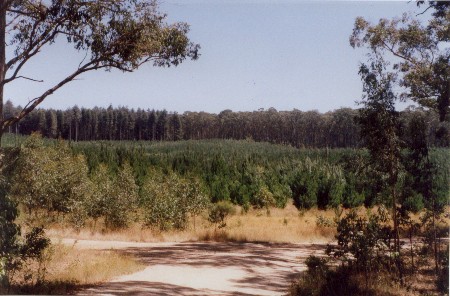
 93-41a: Feb 01: DNRE/Hancock
licence area. Young regrowth in area probably worked over by gold
miners in the late 19th Century.
93-41a: Feb 01: DNRE/Hancock
licence area. Young regrowth in area probably worked over by gold
miners in the late 19th Century. |
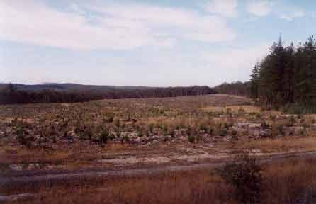
 93-41b:
Feb 01: Large plantation area recently logged in Tullaroop water
supply catchment.
93-41b:
Feb 01: Large plantation area recently logged in Tullaroop water
supply catchment. |
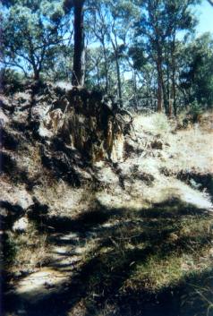 93-41c: Feb 01: Will logging
worsen this erosion? Shot taken most probably in Green Gully which
flows west eventually emptying into Burumbeet Creek and then Lake
Burrumbeet. This area was extensively mined for gold in the 19th
Century.
93-41c: Feb 01: Will logging
worsen this erosion? Shot taken most probably in Green Gully which
flows west eventually emptying into Burumbeet Creek and then Lake
Burrumbeet. This area was extensively mined for gold in the 19th
Century. |
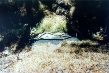 93-41e: Feb 01: Gully erosion
possibly a tributary of Burrumbeet Creek - most likely Green Gully.
Note the black liquid oozing from plantation. Is this old pollution
from ex gold mines in the area? What impact will logging have
in this catchment, especially after periods of heavy rainfall?
93-41e: Feb 01: Gully erosion
possibly a tributary of Burrumbeet Creek - most likely Green Gully.
Note the black liquid oozing from plantation. Is this old pollution
from ex gold mines in the area? What impact will logging have
in this catchment, especially after periods of heavy rainfall? |
HOME
|