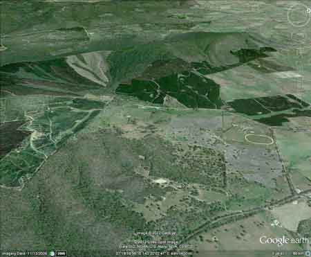
Click here for map of Hancocks' Ballarat region plantations. The Nationally Threatened Temperate Grassland & Grassy Eucalypt Woodland Ecological Community may occur in this plantation or in close proximity. More Information: http://www.environment.gov.au/epbc/publications/pubs/grasslands-victoria.pdf
Avoca River headwaters, looking west, dominated by Hancock pine plantations. A small part of this plantation lies in the Declared Water Catchment of Trawalla Creek. Proclaimed 16/10/63.
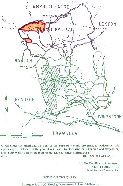
Above - map of Trawalla Creek Declared Water Supply Catchment showing extent of Hancock plantations in headwaters (in orange). Click here for maps of Glenelg-Hopkins RegionWater Supply Catchments This plantation was very likely to be aerially sprayed with 2,4,5-T between 1968 and 1977. The Dioxin TCDD may still exist in soil in this plantation. For more historical data on 2,4,5-T click here. For more information concerning the continuing health crisis concerning 2,4,5-T please forward to here. Herbicides Used by Hancock in Pine Plantations - Ballarat Region Victoria
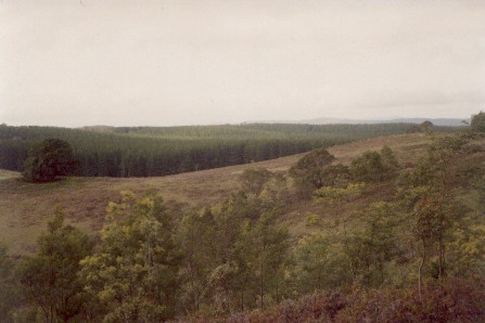
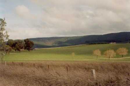
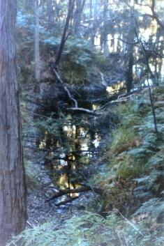
July 2003: This photo faces east and was taken from Little Breakneck Road on the Great Dividing Range. The photo clearly shows some of the headwaters of the Trawalla Creek Declared Water Supply system (covered in pine plantations). Trawalla Creek drains south into Mount Emu Creek and provides water for stock further downstream. The cleared land in the photo foreground drains north into the Avoca River. Some of the northern plantations in this LEGL lie in the Avoca River catchment and come under the following classifications as described by the Soil Conservation Authority:
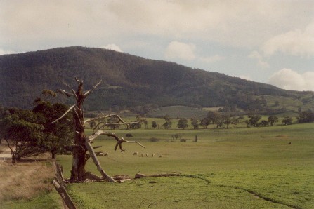
July 2003: Photo facing south south west, looking into the headwaters of the Avoca River. Plantations extend along much of the headwaters of the Avoca River (Dark green vegetation along ridge line). Land System: Pyrenees South. Land Form: Mountain Ridge Geology: Cambrian sandstone and slate. Average Rainfall: 590mm - 625mm. Soil Deterioration: High risk of Sheet erosion with a moderate risk of landslips and gully erosion. Slopes mainly 10-17% Plantation Catchment: This plantation seperates Mount Cole State Forest. The headwaters and at least 5 major creeks (with at least 15 tributaries) of the north flowing Avoca River. There is also a narrow band of land approximately 4km long and 1/2 km wide extending on the eastern face of Mount Lonarch in the Avoca River catchment which is controlled by Hancock. Numerous upper tributaries of the south flowing Trawalla Creek/Mount Emu Creek/Hopkins River also are taken in by this plantation.
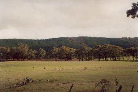
July 2003: The eastern side of Mount Lonarch showing some of this plantation which was probably established on old farmland. Catchment Managment Authority: Glenelg-Hopkins Catchment Management Authority/North Central Catchment Management Authority Hancock Watch Site visit Feb 01: Entered area through LEGL 93-36. Drove down Little BreakneckRoad toward Amphitheatre. Saw recent pine plantations north of main plantation bulk. Turned back and then headed down Avoca River Road. Here there were at least 3 gullys consisting of native vegetation, all of which were marked on the maps. On the LEGL map one appeared to be the downstream HW of the Avoca River - native vegetation in gully with pines on the ridges. Also saw an area of native vegetation extending along Old ? Road, which I perceived to be the boundary of the plantation. More study of the area is warranted.
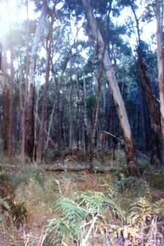
July 2003: Another photo (facing south west) showing the headwaters of the Avoca River which are dominated by pine plantations. Avoca River: Stream is badly silted, turbid and has low summer flow and water level. Upstream from Bealiba: Flows through grazing land, sand and pebble bed. This is the only section of the river which has clear water for the whole year. Predominately redfin average 250g, maximum 500g, brown trout to 700g, tench, carp, goldfish and small river blackfish. Other Notes: Soil Conservation Authority: An Ecological and Land Use Survey of the Trawalla Creek Catchment 1962. “p2 . . . The catchment is within hilly country composed of Ordovician sediments and is adjacent to the Great Dividing Range near Beaufort . . . The only source of freshwater are likely to be those tributaries draining sedimentary hills and Trawalla Creek is the biggest of these streams and it is desirable for the high quality waters in Trawalla Creek to be maintained . . . p3 The Headwaters of Trawalla Creek rise on the southern slopes of the Great Dividing Range to the north of Beaufort in the Central Highlands Region. After flowing for ten miles in a south easterly direction it empties into Mt. Emu Creek near Trawalla . . . p4 Hills of Ordovician shales and mudstones have been maturely dissected by Trawalla Creek and its tributaries . . . The catchment is sharply defined on the east, north and west by high ridges from which spurs and lower hills gradually drop in elevation until the plain of Trawalla Creek is reached . . . The northern ridge is part of the Great Dividing Range whose elevation above sea level is generally between 1500 feet and 1700 feet culminating in Ben Major at 2000 feet . . . p5 Solodic soils are the dominant soil group. They are divisible into two sub-groups, namely, red solodics and yellow solodics, and their chief feature is a sharp and marked texture boundary. Red solodic soils are associated with the Ordovician hill slopes. They derive their name from the red to reddish-brown clay of the subsoil which underlies a light brown, gravelly, sandy loam. A characteristic feature of these soils is the large amounts of quartz stone in the upper horizons, the stones being particularly noticeable on those profiles exposed along road cuttings. Sometimes red podzolics are found which differ from red solodics in having a clay loam horizon between the sandy loam and clay . . . p6 Associated with the Ordovician hills and red solodics is a mixed dry sclerphyll forest of messmate, red stringybark, narrow-leaf peppermint, long leaf box and apple box . . . p11 The contribution made by Trawalla Creek to Mt Emu Creek includes both the quantity of water and its quality . . . the quality of water from Trawalla Creek is of greater importance to Mt Emu Creek than the quantity . . . Trawalla Creek drains the area of highest rainfall within Mt Emu Creek’s catchment . . . It appears that Trawalla Creek contributes most the of the good quality water that enters Mt Emu Creek and dimunition of this quality would increase the salinity of Mt Emu Creek . . . p12 In view of the low productivity and revenue arising from the present eucalypt forests, the Forests Commission should be asked to investigate the suitability of the Reserved Forests for pine plantations as an alternative cover to the present eucalypt forests . . .”
Mount Emu Creek: Flows through forest and grazing land, (basalt country) with a rocky bottom in many sections and deep pools. Scattered red gums along banks. Considerable erosion in the upper catchment. Source: A Guide to the Inland Angling Waters of Victoria by BR Tunbridge, PL Rogan, CA Barnham. Department Conservation and Environment. Arthur Rylah Institute for Environmental Research, 123 Brown St, Heidelberg, 3084. (4th ed - 1991)
|