Region: StrzeleckisLegal Number: LEGL/93-114Plantation: Leongatha
Conservation Priority: Medium |


| Herbicide | Label Rate max as kg/ha | Used to control | Euc/Rad | Notes | Application |
| Clopyralid | 2.55 | Woody Weeds | Radiata and Eucalypts | Highly Toxic/Potential Ground water Contaminant | aerial or ground |
| Glufosinate Ammonium | 1 | Woody Weeds | Radiata | aerial or ground | |
| Glyphosate | 3.6 | Herbaceous and woody weeds, noxious weeds | Radiata, Eucalpts and Custodial | ||
| Haloxyfop-methyl | 0.13 | Annual and Pernneial Grasses | Eucalypts | Carcinogen | aerial or ground |
| Hexazinone | 4 | Woody Weeds | Radiata | Ground Water Contaminant | Aerial, ground, spot |
| Metsulfuron-Methyl | 0.06 | Woody Weeds, Noxious Weeds | Radiata, Eucalyptus and Custodial | Potential Ground Water Contaminant | Aerial, ground or spot |
| Sulfometuron Methyl | 0.6 | Annual and Perennial Grasses and broadleaf weeds | Eucalyptus | Potential Ground Water Contaminant | Aerial or Ground |
Responsible Authority: South Gippsland Shire Council
Plantation Catchment: 2 creeks/2 HW running SE into Tarwin River West Branch/Anderson Inlet/Venus Bay. Two plantations seperated by farmland.
Catchment Managment Authority: West Gippsland Catchment Management Authority
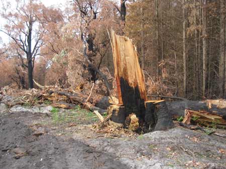
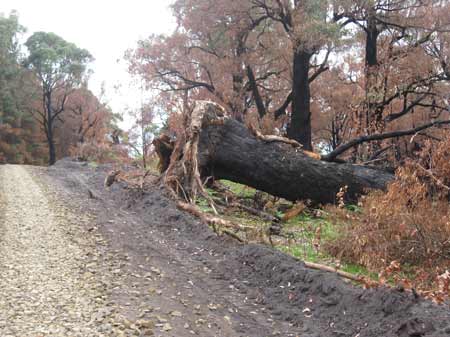
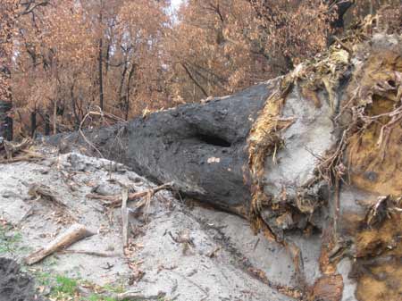
May 2013: Old growth destroyed for no reason
Hancock Watch Site visit Jan 01: Travelled along Forresters Road. Went into plantation on west side. Scattered remnant old growth stringybark etc at north end of plantation. Found a wedgetail eagle feather. Possibly 50 trees in all. Travelled into plantation on east side. Area borders State Forest with mixed species - mainly stringybark regrowth. Not many older trees - trees possibly 40 - 50 years old. Northern aspect covered in regrowth. Pine plantations established on east side of northern aspect of plantation. Drove down main access track. Possibly 500 metres of regrowth stringy on both sides of track. Drove into plantation. Road average in places. All tribs marked on LEGL's dominated by pine. Occasional euc's in plantations including old trees. Buffer of Manna Gums and farmland along Tarwin River West Branch. River looked in poor shape. Not much flow.
Tarwin River, Tarwin - Alambee South to Wilkur Creek: Slower flowing water with deep holes, mud and sand bottom. Contains some brown trout to 350g, average 90g, but occasional larger fish. Abundant river blackfish and tupong. Access restricted by private property.
Source: A Guide to the Inland Angling Waters of Victoria by BR Tunbridge, PL Rogan, CA Barnham. Department Conservation and Environment. Arthur Rylah Institute for Environmental Research, 123 Brown St, Heidelberg, 3084. (4th ed - 1991)
 |
 |
 |