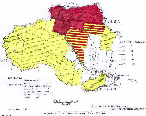
(Above) Map showing extent of Hancock land which lies within the Tarra River Domestic Water Supply Catchment. Marked in yellow. Land marked purple is Tarra Bulga National Park and the land marked with yellow and purple stripes is land leased from the Crown for forestry purposes - eg Potential Pulp for the PaperlinX pulp mill.
Click here for Merriman's Creek Water Supply Catchment.
Tarra River water catchment lies on the south face of the Strzelecki Ranges and was proclaimed by the Victorian State Government on 26th January 1971.. Original vegetation within the catchment would have been dominated by cool temperate rainforest and mountain ash. Remnants of this original forest type remain in isolated pockets and gullies. Much of the water catchment was controlled by the Victorian State Government up until November 1998, when much of the land that was controlled by the Victorian Plantations Corporation was leased out to the American company John Hancock Financial Services. The Tarra River also supplies drinking water to the towns of Alberton and Port Albert.
Amcor, also owned private land within the catchment boundary. Some of this private land was included in the Tarra Bulga National Park, however 4 allotments of land located just off the Grand Ridge Road, remained under Amcor control. These allotments included 16, 17, 18, 20 Section C Parish of Bulga. Much of these allotments were logged in 2003 and herbicide application will occur in the near future. These allotments are now controlled by John Hancock Financial Services who bought out the plantation assets of PaperlinX (Amcor's predecessor) in August 2001.
Ex State owned pine plantations within this catchment now controlled by Hancock also include: Click on the following numbers for further information - LEGL93-92, 93-93, 93-96.

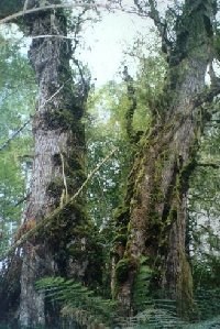
Ex- Amcor land bordering Tarra Bulga National Park. No buffers left on this cool temperate rainforest. September 2003.
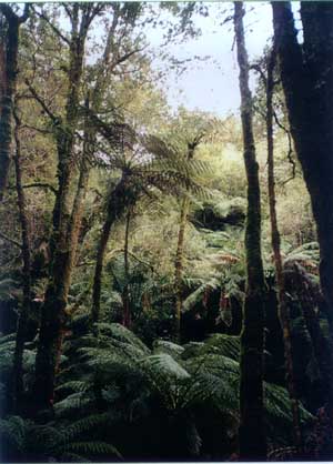
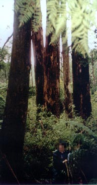
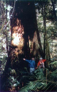
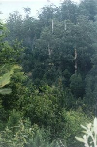
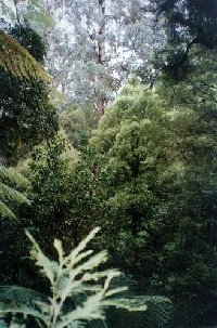
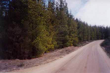
3 different photos showing cool temperate rainforest in the South Middle Creek catchment which flows into the Tarra River.
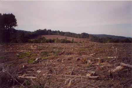
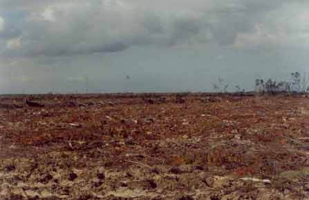
Probably allotments 16 & 17 Section C Parish of Bulga in the headwaters of the Tarra River Water Supply Catchment. Recently clearfelled by Hancock - July 2003.
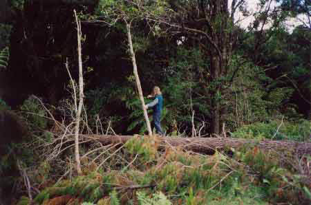
Ex- Amcor land bordering Tarra Bulga National Park. No buffers left on this cool temperate rainforest. September 2003. Probably allotment 18 Section C Parish of Bulga.
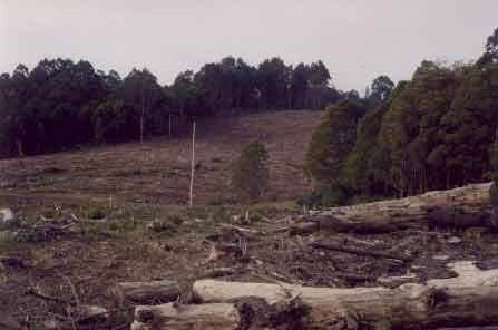
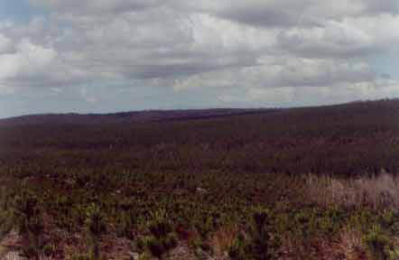
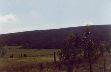
July 2003: Strzelecki Ranges (Allotment 16 Section C Parish of Bulga) - Recent pine plantation logging in the South Middle Creek catchment in the Tarra River Water Supply (proclaimed 26th January 1971). This catchment supplies drinking water to the towns of Yarram, Alberton and Port Albert in South Gippsland. Australian Paper Plantations owned 4 allotments of land in this catchment located in the Parish of Bulga. The allotments 16, 17, 18 and 20 section C are all now mortgaged with Westpac Bank after the Hancock takeover of A.P.P in 2001. Many plantations in the Strzeleckis have been planted in close location to Cool Temperate Rainforest and may well threaten the long term survival prospects of such rainforest. South Middle Creek contains a large amount of Cool Temperate rainforest.
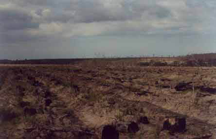
Recent plantation clearfelling lower down the Tarra River catchment in ex-Victorian Government plantations. Note the non-plantation species competing with plantation trees. In order to kill this regeneration herbicides are aerially sprayed by the plantation company. This is not a good land use in a domestic water supply catchment.
For a map of Merrimans Creek Domestic Water Supply Catchment click here.
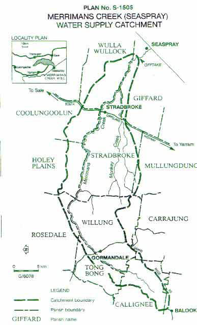
This water supply is a long catchment stretching primarily from west to east on the north eastern face of the Strzelecki Ranges and is 544 square kilometres in size. The catchment extends west from the offtake through three topographical zones, the eastern-most is of Quaternary sediments the topography of which are hills and swales and plains. The central zone is dominated by the Tertiary sediments which have a moderate hill relief. The third zone, forming the headwaters for Merrimans Creek consist of Cretaceous sediments interspersed with older basalt cappings taking the form of deeply dissected hills.
The soils of the catchment include leached sands which may or may not have a cemented layer, isolated pockets of duplex soils interspersed with the sands, brown gradational (sedimentary) and red gradational (volcanic) soils.
Seaspray has a population of about 700, with numbers swelling to about 5000 in summer.
The upper headwaters of the catchment are located on quite steep slopes (in places). There is also a small stand of remnant cool temperate rainforest that remains in the headwaters of this catchment. Lower down, the catchment become less steep and in the lower portion of the catchment the land is quite flat. APM established vast pine plantations in the lower portion of the catchment and many of these are now being logged by Hancock.
Over 90% of the headwaters of the catchment are controlled by Hancock Victorian Plantations on plantations established by the Victorian Forests Commission. These plantations are located in the Parishes of Bulga and Callignee. There are also extensive plantations in the Parishes of Willung and Tong Bong further down the catchment that were established by APM (now Hancock). Ex APM plantations also have been extensively established in the Parishes of Rosedale and Stradbroke. Small areas of ex APM plantations in the Parishes of Coolungoolun and Holey Plains have also been established in the Merrimans Creek Water Supply Catchment.
Ex State owned pine plantations within this catchment now controlled by Hancock also include: Click on the following numbers for further information - LEGL93-106, 93-107, 93-108, 93-116.
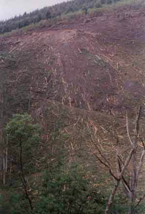
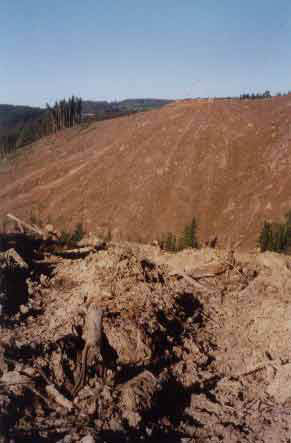
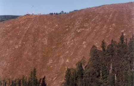
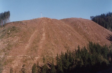
Photos showing recent clearfelling of pine plantations in the upper reaches of Merrimans Creek. July and September 2003. These plantations in the upper headwaters of the catchment are located on soils that are highly erodable. Cretaceous Sediments.
Parish of Callignee Clearfell of pine near the headwaters of Merrimans Creek. October 2003.
Parish of Callignee. Remnant cool temperate and old growth forests still remain near the headwaters of this catchment, although their long term future is precarious.

Parish of Willung, further down the catchment showing ex APM plantations now owned by John Hancock Financial Services. Plantation located on Tertiary Sediments.
Parish of Willung. Ex APM plantations of which about 676 ha are leased from the government under a Plantation Lease Agreement signed on 1/1/85 for 35 years. The rest of the Willung plantations are now owned by Hancock Victorian Plantations. This area is in the Bayliss Creek catchment which is a tributary of Merrimans Creek.
Allotment 307E Parish of Rosedale - which comes under a lease to APM signed on 1/2/63 under the Land (Plantation Areas) Act 1959. This particular 60 year lease includes some 2742 acres of land. APM (PaperlinX) have an annual lease fee for this land of $180. This particular plantation straddles the ridge between Merrimans Creek and the Latrobe River Catchment. This plantation is in close proxiimty to Merrimans Creek.
Allotment 51 D Parish of Tong Bong on land that was also leased to APM under the Land (Plantation Areas) Act 1959. This plantation is located about 3km north east of the Gippsland town of Gormandale.
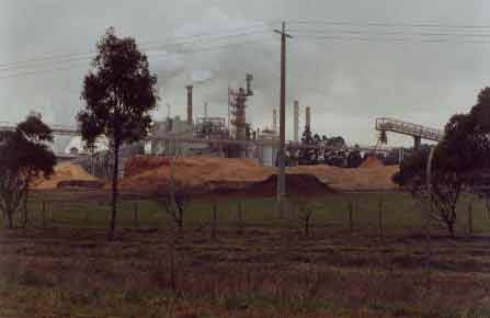
Maryvale pulp mill, owned by Paperlinx. This is the ultimate destination for pine plantations grown in the Merrimans Creek Catchment.
Parish of Stradbroke. Extensive plantations owned by Hancock lie in this Parish. Note the typical flatness of much of this land. One worry may be the application of herbicides such as Hexazinone, Cloyralid and Simazine which are known to leach into groundwater - especially in sandy soils.
Parish of Stradbroke. More pine trees being planted for pulp in the Merrimans Creek Water Supply Catchment.
Recent pine logging in the Mt Joy region of the upper reaches of the Merrimans Creek Catchment. Soils are the highly erodable Cretaceous Sediments.