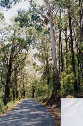
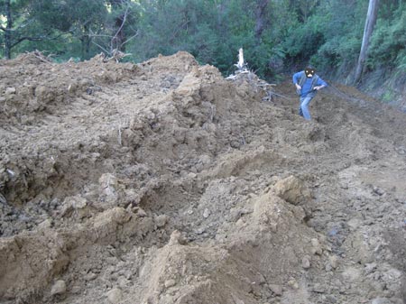
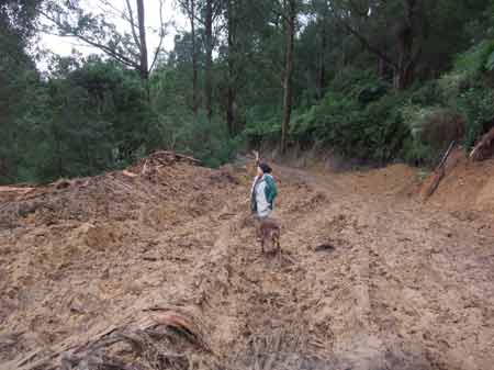
January 2004 - Strzelecki Ranges: Budgeree Road. Damp Forest which is an Endangered Ecological Vegetation Class in the Strzelecki Bioregion. This forest type is supposed to be afforded the highest level protection under Victorian State Government law. This forest contains habitat for Koalas, Powerful Owl, Quolls? and Greater Gliders. This road has been identified by Grand Ridge Plantations (Hancock) as an Identified Timber Haulage Route. Local Government and the Victorian Farmers Federation are also lobbying for this forest to be cleared and the road widened.
Super Koala Habitat Faces Bulldozing Oct 2 2005 (The Age)
CRITICAL habitat supporting the so-called Strzelecki "super-koala" and endangered powerful owls is to be bulldozed as part of a controversial road-widening project in South Gippsland. Several hundred trees, many home to koalas and with hollows suitable for nesting owls and other wildlife, will be lost, despite consultants warning the Latrobe City Council that the damp forest habitat is virtually irreplaceable in a region largely cleared of native vegetation. The local member for Morwell, Brendan Jenkins, is appealing to Environment Minister John Thwaites for an 11th-hour reprieve after local conservationists lost their case in the Victorian Civil and Administrative Tribunal. Latrobe Council wants to widen Budgeree Road so that logging trucks servicing plantations can pass each other. Trucks now travel one way down the road and return via another route. Budgeree Road is also a tourist drive to Tarra Bulga National Park. The tribunal initially raised strong objections to the project, near Boolarra, in the face of evidence that the council took little account of the vegetation affected, that traffic volumes did not justify the scale of the works, and that a redesign could save most trees. Then, in a surprise turnaround, it approved the project last month with minor amendments. Advertisement Advertisement Strzelecki koalas are a genetically superior group that may hold the key to the species' long-term survival in Victoria. All other koalas in the state are descended from a handful of individuals transferred to French Island more than a century ago, a few years before koalas were hunted to near-extinction on the mainland. The French Island colony was used to repopulate the state, but inbreeding is now becoming apparent. The Strzelecki koalas, however, appear to be a remnant of the original and genetically diverse mainland population. The roadside forest is rare in its own right, being of "very high conservation significance". This category has legislative protection under the Native Vegetation Management framework, and can be cleared only under exceptional circumstances. The loss of hollow-bearing trees is also listed as a threat under the Flora and Fauna Guarantee Act. Consultants from Biosis Research told Latrobe Council it would be difficult to find other damp forest areas that could offset the loss of roadside remnants. Susie Zent, from Friends of the Gippsland Bush, said VCAT had set conditions for the roadworks based on a mistaken classification by the Department of Sustainability and Environment as to the vegetation's significance. She said the VCAT decision could be set aside if the department admitted to an error of judgement and requested amendments to its permit conditions. Latrobe's chief executive officer, Paul Buckley, said he expected VicRoads to sign off the final plans within three or four weeks. He said the additional width was needed to improve safety. A spokesman for Mr Thwaites said the department was waiting for final details from the council, particularly in relation to offset measures. "Offset measures are required to ensure there is no overall loss of areas that have ecological significance," he said.
Road widening plan triggers green fears Oct 4, 2005 ABC News
Latrobe City Council is considering scaling back a road widening project to protect sensitive vegetation in the Strzelecki Ranges. A Victorian tribunal has rejected an appeal against council's plan to widen Budgeree Road near Boolara. Conservationists say hundreds of trees will be bulldozed if the road is widened to improve access for log trucks. They are concerned habitat for koalas and endangered powerful owls will be destroyed. The council's Michael Edgar says a more environmentally sensitive design is being drafted. "The road widening varies along the road width anyway, on the straight sections it's a particular width and on the bends it needs to be a little bit wider to accommodate the turning movement of the trucks," he said. "Overall what we're looking at is whether or not we can reduce the overall width of the road but still retain the safety features, if it's a lesser width then there's less impact on the vegetation." Susie Zent, from the Friends of the Gippsland Bush group, says the roadside forest is of very high conservation significance. "I've been in the area for 30 years and that road is far safer, has better paving on it than many other roads in the region and I think other money could be spent far more wisely educating people and upgrading roads that are in far worse condition," she said.
Council agrees to reduce road widening Oct 19, 2005 ABC News
Latrobe City Council has voted to scale back a road widening project in the Strzelecki Ranges. The council wants to widen Budgeree Road to improve access for log trucks. The Friends of the Gippsland Bush group took the case to a Victorian tribunal, but the appeal was rejected. The council's Michael Edgar says council has decided to reduce the width of the original roadworks by 1.5 metres. He says the revised plan will reduce the number of sensitive trees and ferns that need to be logged. "It would bring the number of trees down from the hundreds down to probably less than 40 as part of these works, so there's be a positive impact, certainly initially, to the roadside vegetation," he said. But Susie Zent from the Friends of the Gippsland Bush group says the Latrobe council still plans to fully widen the road in the long-term. She says the decision to go ahead with the roadworks represents environmental vandalism. "There's two stages to this project, the first stage they claim they're only taking 40 trees, but we don't know which sections, it could be oldest growth section on the road and the second phase is to go to the original plan which is removing hundreds of trees," she said.
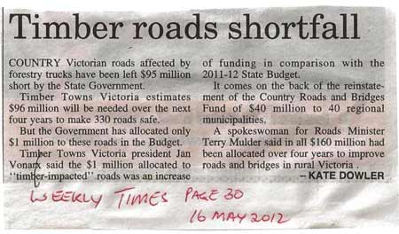
TIRES Road Funding Strzeleckis
In 1997, a Department of Natural Resources and Environment Report, Infrastructure Impediments in Private Forestry, described a statewide strategy for developing infrastructure to provide cost-efficient transport for an expanded internationally competitive Victorian timber industry. The major impediment was the cost of upgrading and enhancing local roads and bridges to cope with increased timber haulage traffic from new areas.
Under the TIRES (Timber Industry Roads Evaluation Study) 307 local road and bridge upgrading projects were identified statewide in December 2000. These works were estimated to cost about $100 million over 10 years. Timber Towns Victoria (TTV), in cooperation with the Private Forestry Council of Victoria and Vicroads steered TIRES in order to develop transport for 'an internationally competitive Victorian timber industry'. TIRES was seen to meet the objectives of the Commonwealth Government's Vision 2020 for plantation development (which plans to treble the Nation's plantation base by the year 2020) and Regional Forest Agreements. TTV spearheaded the TIRES campaign.
The Chief Executive of Vicroads advised that $3.3 million of Better Roads Victoria (BRV) would be made to local timber roads in 2001/02 and that more funding would be allocated towards local roads based primarily on the recommendations of the TIRES Report. Local governments get funded through the scheme to widen roads primarily for the interests of the logging industry. Hancock will be the main beneficiaries of TIRES in the Gippsland region (and probably statewide) and will benefit by the destruction of High Conservation Valued Forest such as the forest identified above on Budgeree Road. How can this be a justified sustainable outcome?
The Statewide TIRES Committee included:
John Tanner (Chair), John Houlihan - Private Forestry Council/DNRE, Peter Anderson - Department of Infrastructure, Kevin Hadingham - Vicroads, Jon Drohan & Kevin Wright - Victorian Association of Forest Industries, Malcolm Tonkin - Plantations Australia.
North East Committee: 8 municipalities - John Tanner
Gippsland Committee: 6 Municipalities - Cr Helen Hoppner
Central West Committee: 10 Municaplities - Cr Bob Orr
South West Committee: 5 Munipalities - Cr Mick Murphy
Case Study 1: Jumbuk Road Strzelecki Ranges September - November 2009
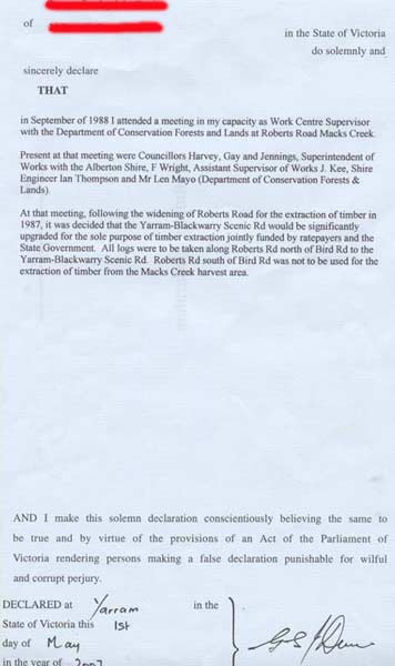
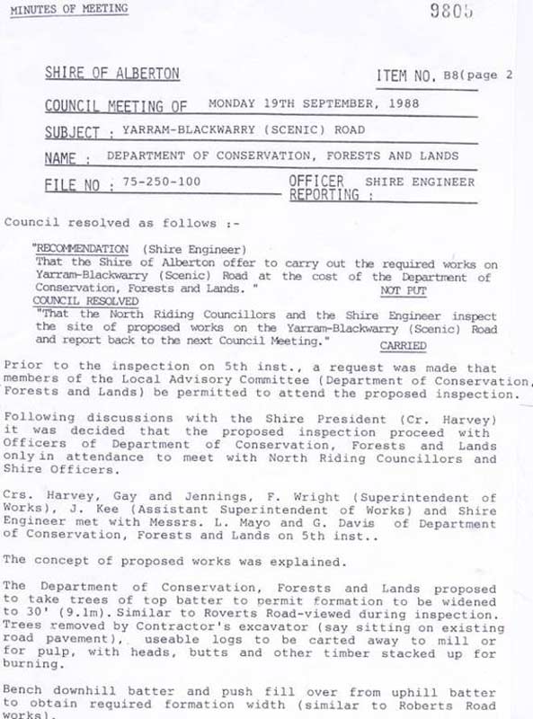
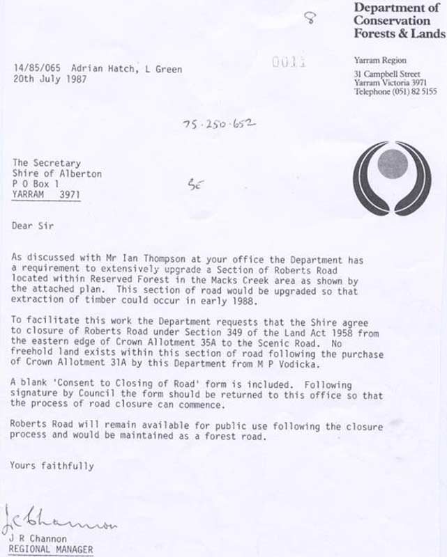
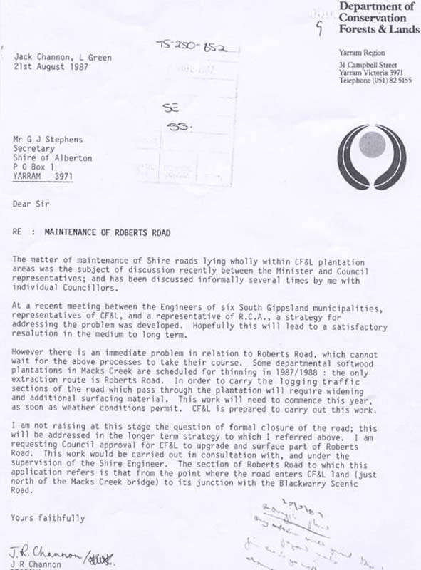
Case Study 2: Roberts Road Strzelecki Ranges 2007-2009
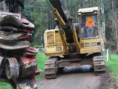
June 2010: Strzelecki Ranges/Middle Creek Catchment. Local residents have to endure Hancock logging equipment on their roads (this shows logging equipment on Middle Creek Road). Who pays for road maintenance? Contractors promised that they wouldn't be using Middle Creek Road, but they are. This road was made undrivable by non-4WD vehicles for weeks after this event.
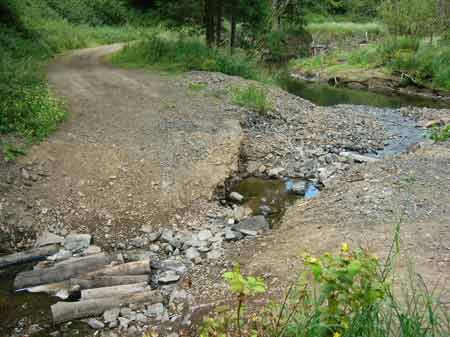
October 2011: College Creek - Site of National Conservation Significance and Rainforest Reserve. Culverts removed after logging!
October 2011: College Creek - Site of National Conservation Significance and Rainforest Reserve
May 2012/Strzelecki Ranges: Ward Road
May 2012/Strzelecki Ranges: Ward Road
February 2011/Strzelecki Ranges. We have witnessed many kilometres of crown reserves removed by Hancock over the years
July 2010: Strzelecki Ranges/College Creek. Burning of crown roadside reserve - Grand Ridge Road.

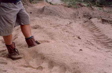
August 2009 - Otway Ranges Gellibrand River/Stevensons Falls. Note deep wheel ruts.
December 2007: Strzelecki Ranges - Middle Creek catchment. Where Smiths Creek meets Middle Creek. This is a hazard to members of the public who use this road and also is a hindrance to fire fighting, as fire trucks will not be able to negotiate this road.
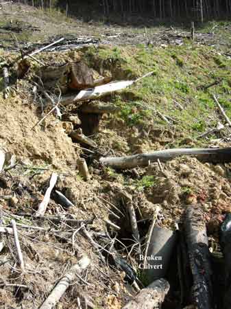
October 2007 - Otway Ranges - Gellibrand River Catchment. Stevensons Falls Plantation. This is the site of where a culvert has either washed out or has been deliberately broken. The culvert has been replaced with a log, which in turn has caused a scouring of the drianage line. All of this has occurred with FSC's apparent blessings. FSC operations are only audited once a year (over a week period) meaning that the vast majority logging coupes are not audited at all.
April 2004: Northern Strzeleckis/Jeeralangs. Traralgon Creek Catchment - west side. Ex state government plantation planted to pine in 1973. Close up of soils on logging track inside plantation. In the event of heavy rainfall this will create massive soil movement. For more information about this ex state owned plantation click here. Note also that applications of herbicides on sandy soils can lead to groundwater pollution.
April 2004: Northwest Strzeleckis. Ex APP land. Allotment 14 - Parish of Allambee East (Deadlock Creek/Tarwin River Catchment). A logging road has been 'upgraded' through the western side of Deadlock Creek. For more information about proclaimed water catchments in Gippsland click here. About 1000 hectares of pine plantation occurs in the Deadlock Creek catchment.
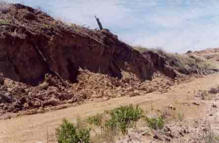
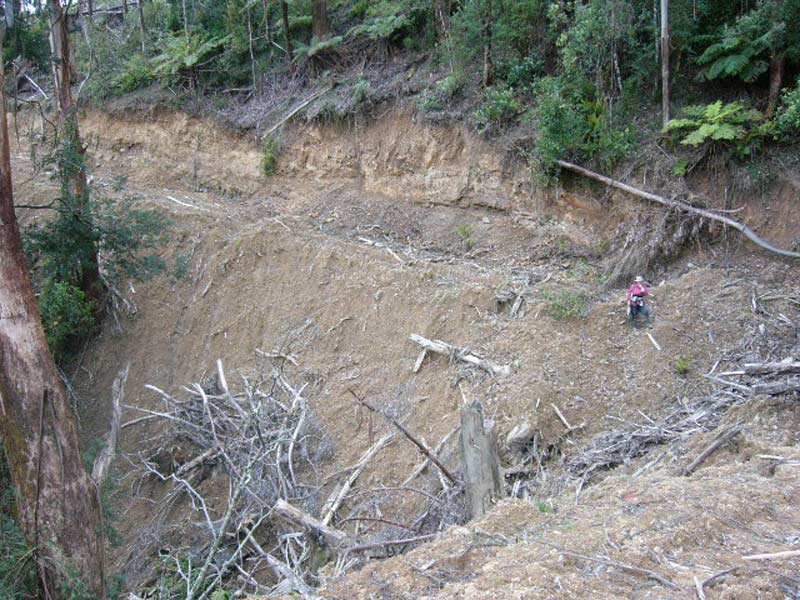
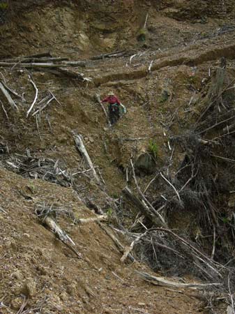
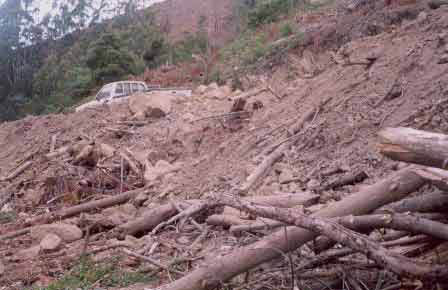
Feb 04: Albert River Tributary - Southern Strzelecki Ranges. Badly eroding logging track west of Fairview Track- note collapsing road batters. No remediation has taken place at this site. Large amounts of topsoil have been displaced. This is an unsustainable outcome.
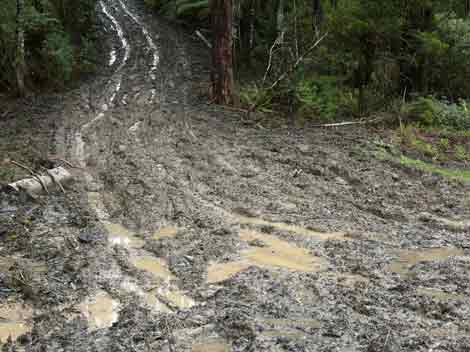
September 2004 - Strzelecki Ranges: Appalling roading and drainage on Snakes Back Track in the Morwell River Catchment. This exact spot was known to be habitat for the endangered Strzelecki Burrowing Crayfish.
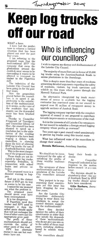
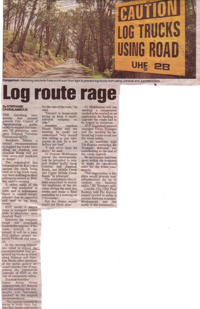
October 10 2011: Residents plan to fight Latrobe Valley Express
Residents plan to fight By Nikita Vas 10 Oct 2011.
THE removal of 30 trees and a recent Latrobe City Council decision to tear down some native vegetation have left residents adamant they will bring their fight to the Victorian Civil and Administrative Tribunal. Council recently voted in favour of the removal of 2300 square metres of native vegetation along Jumbuk Road to allow the widening of the road. Prior to council's decision, more than 30 trees were sighted to have been removed near the area, instigating a fierce response among residents. Jumbuk resident Richard Northover said the removal of some trees prior to council's decision made him question if a double standard existed within the law. "There's rules for us and none for (Latrobe City Council) ... I guarantee you that the land will slip in three to four years if they continue along the path they're heading," Mr Northover said. "As a ratepayer I don't want to have to pay for repairs once that happens." Mr Northover said Latrobe City Council's decision had instilled fear in the residents who were hoping VCAT would stop the removal of 170 trees before "it's too late". Jumbuk resident Bill Roberts slammed council's decision as "schizophrenic" saying it underestimated the road conditions by approving the widening of its corners, so trucks carrying timber would be able to travel through. The decision to allow log trucks to travel via Jumbuk Road has left a fellow resident Brian Kilday fearing the road would not be able to handle the additional weight. Mr Kilday said residents would not have had a problem if the road met council's minimal requirements. "Council are not prepared to meet its standards because it would involve additional costs," Mr Kilday said. "They've understated the load of trucks and overstated the cost of works needed. "The issue is the road isn't going to be safe... Jumbuk road is the lowest rated road." Jumbuk residents said council's refusal to pay heed to an alternative, safer route put forward by residents displayed a "lack of consistency". Latrobe City acting manager built and natural environment Michael Edgar confirmed council was not involved in the illegal removal of the 30 trees. "This alleged vegetation removal is not directly related to the proposed vegetation removal which was considered as part of a planning application by council on 3 October," Mr Edgar said. Mr Edgar said council had commenced investigation to establish how the vegetation removal may have occurred. In response to residents' concerns regarding potential landslips, a report prepared on behalf of council by GHD Pty Ltd made recommendations which were adopted by council. However, Jumbuk Road residents believe the recommendations made by the report to curb any problems during the widening process, would be measures taken too late and have opted to approach VCAT instead.
See Latrobe City Council Minutes October 3 Page 111
VicRoads allocated $280,000 in the 2010/2011 financial year under the Better Roads Victoria Rural Local Timber Roads Program to stage 1 of the upgrade works and Latrobe City Council has allocated $200,000 to the project within 2011/2012 capital works budget.
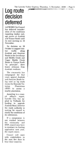
April 8 2010: Log Decision Angers (Latrobe Valley Express)
Log decision angers BY STEPHANIE CHARALAMBOUS AND EBONNIE LORD 08 Apr, 2010
TENSION between Latrobe City Council and the Jeeralang community was high at Tuesday's council meeting when the City continued its push to allow log trucks to use Jumbuk and Junction roads. The community has campaigned for four years against the roads being used by log trucks contracted to Hancock Victorian Plantations (HVP) which needs a secure route to transport timber from a plantation near Jumbuk. Council and VicRoads are expected to jointly fund upgrades to the roads, but residents say the project does not go far enough to address their safety fears. Will Ernst drops his daughters aged eight and 10 off at the Junction/Jumbuk road bus stop at 7.50am every school morning and was one of six speakers at the meeting opposed to the log route. He said he feared for his children's safety when he could not pick them up. ``The council say it will be just for the next 10 years, but that's my daughters' whole school education and who's to say the council won't extend the time for HVP?,'' Mr Ernst said. Council moved a recommendation two-way timber traffic use the roads, one truck at a time with voluntary 40km/h and 60km/h speed restriction on parts of the route. Trucks are not permitted on the roads when school buses are using them. Residents told the meeting they feared the roads were not wide enough to pull over safely to make way for trucks and sharp bends prevented them from seeing oncoming traffic. Jumbuk Junction Safety Action Group spokesperson Bill Roberts told the meeting ``all we're arguing is we don't want to get run over, a log truck can do 40km/h and still kill you''. ''They have identified 11 points where they can widen the road, but what about everywhere else?,'' Mr Roberts said. Councillors Rohan Fitzgerald, Sandy Kam, Kellie O'Callaghan and Sharon Gibson voted against the motion. Cr Ed Vermeulen told the meeting he believed the establishment of a community reference group would be an appropriate forum for the residents' safety concerns. It is believed HVP's predecessors had an agreement with Morwell Shire Council about the log route. Latrobe City acting chief executive officer Michael Edgar would not comment on whether the agreement was considered legally binding and whether that was the reason for council's stance.
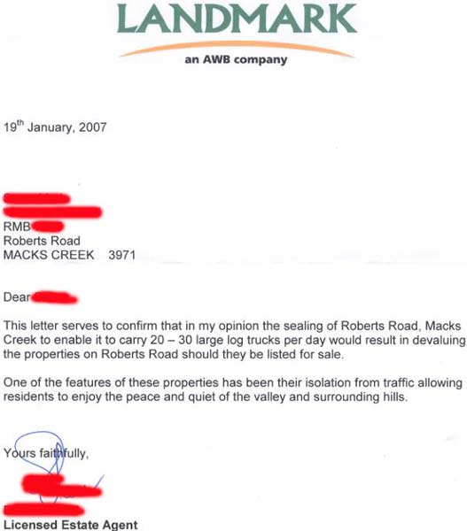
Submission to the Wellington Shire 07.05.07 regarding proposals to replace Bookers Bridge and upgrade Roberts Road compiled by Affected residents
We ask that the above proposals not proceed for the following reasons: * Community * Environmental * Economical * Current and alternative routes * Validity of applications * Bridge condition
What benefit to the wider community of Wellington Shire and the local community will the replacement of Bookers Bridge and the upgrade of Roberts Road provide? We can find none. In fact we believe that the opposite will occur that should this proposal go ahead it will be to the detriment of both communities. Should this proposal be abandoned ; No jobs will be lost · Grand Ridge Plantations, a subsidiary of Hancocks, will be quite capable of absorbing the extremely small cost of a slightly longer route · Logs will continue to be successfully transported to the Yarram Mill via the safest route ie The Blackwarry Road dual all weather road upgraded specifically for use by log trucks see information local paper and archives 1988 · Residents will continue to travel Roberts Road, their only route to services in their local town and beyond, in safety · Wellington Shire can use the money saved more appropriately
Should the proposal go ahead · The Barn at Glenwood will be unable to be run as a viable business due to restriction of trade, ie expenses will remain the same but bookings will be severely restricted · Bookings will only be taken if Grand Ridge Plantations can make assurances to owners that log trucks will not travel on Roberts Road at these times these assurances are not legally binding and will be subject to change should Grand Ridge Plantations so wish · Grand Ridge will in effect control these bookings and will have to be consulted constantly, therefore controlling the management of The Barn at Glenwood · Log trucks may travel the road as early as 3.30am as is currently happening on Bulga Park Rd if they choose, in fact at any time day or night impossible to market Bed & Breakfast during the week · Grand Ridge Plantations benefit ratepayers/tax payers provide a free road. · Glenwood Farm lose main source of income/livelihood earn locally, spend locally. · Largest customer not in Wellington Shire could it be that the largest percentage of timber from Macks Creek with be taken out of the Shire to Paper LinX in the Latrobe Valley ?. · Outside contractors involved in construction of road/bridge what is the guarantee that they are from Wellington Shire and contribute to our economy. · Road funded by Wellington Shire that suits the wants of Grand Ridge Plantations, with most of the timber transported to and processed in other shires (community benefit none ) · Devaluation of all properties on Roberts Rd.

Reasons Councils are reluctant to rock the boat Many rural councils exhibited an area of 40 hectares to retain a mechanism to address the issue of road damage. Councils contend, and the timber industry acknowledges, that logging trucks can cause substantial damage to roads and bridges, particularly due to the concentration of heavily laden vehicles during harvesting operations. The timber industry is concerned that if permits are required, plantation expansion will be impeded and potential investors will be discouraged. This would be contrary to the Victorian Private Forestry Strategy Private Forestry in Victoria: Strategy Towards 2020, May 1998, a joint industry-government strategy that aims to treble Victorias plantation area by the year 2020, in line with the national target for plantations set in July 1996 by the Ministerial Council on Forestry, Fisheries and Aquaculture. The timber industry is also concerned that councils will impose a range of disparate conditions on permits, particularly relating to the issue of roads. This will undermine the opportunity to achieve a consistent statewide approach to timber production. Panels/advisory committees for the new format planning schemes have recommended a consistent statewide approach to resolving this issue.