Region: Ballarat
Legal Number: LEGL/93-24
Plantation: Castlemaine
Plantation is located approximately 2km north east
of the town of Castlemaine and represents a major fire hazard.
Conservation Priority: High
Plantation within AKD Softwoods area of supply.
|
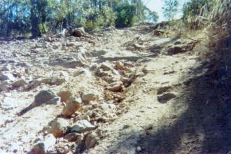
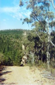 93-24a Feb 01: Southern
boundary track. Photo doesn't pick up steepness of the track,
but this track is one of the worst examples found.
93-24a Feb 01: Southern
boundary track. Photo doesn't pick up steepness of the track,
but this track is one of the worst examples found. |
|
February 12 2013: Castlemaine
Pines Fire Causes Concern
February 18 2013: Castlemaine
Plantation a High Fire Risk Says Research
Castlemaine
Goldfields Limited currently
conducting Gold Exploration in this plantation.
"We have carried out a conceptual study into locating a portal
and plant nestled within the plantation. We are comfortable with permitting
issues at this time in this area that is devoid of any park values and
buffered away from housing."
Plantation within SPE Exports (Geelong) area of supply.
Responsible Authority: Mount Alexander Shire Council
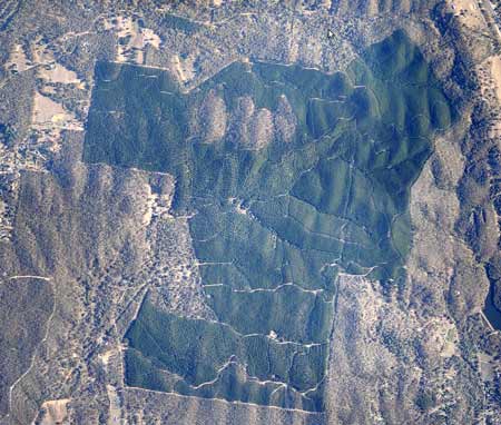
Image of plantation early 2012: Image
Source Nearmap
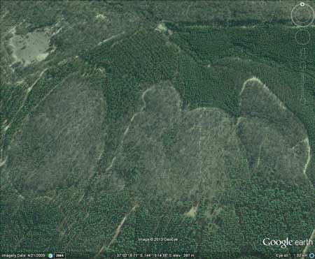
Over 20ha of native forest lies within this plantation
boundary. The plantation is also surrounded by thousands of pine wildings.
Click
here for map of Hancocks' Ballarat region
plantations.
This plantation was very likely to be aerially
sprayed with 2,4,5-T between 1968 and 1977. The Dioxin TCDD may still
exist in soil in this plantation. For more historical data on 2,4,5-T
click here.
For more information concerning the continuing health crisis concerning
2,4,5-T please forward to
here.
Herbicides Used by Hancock
in Pine Plantations - Ballarat Region Victoria
| Herbicide |
Label Rate max as kg/ha |
Used to control |
Notes |
Application |
| Clopyralid |
2.55 |
Woody Weeds |
Highly Toxic/Potential Ground water Contaminant |
air or ground |
| Glufosinate
Ammonium |
1 |
Woody Weeds |
|
|
| Glyphosate |
3.6 |
Herbaceous and woody weeds, noxious weeds |
|
|
| Hexazinone |
4 |
Woody Weeds |
Ground Water Contaminant |
Aerial, ground, spot |
| Metsulfuron-Methyl |
0.06 |
Woody Weeds, Noxious Weeds |
Potential Ground Water Contaminant |
Aerial, ground or spot |
| Triclopyr |
3 |
Woody and Noxious Weeds |
|
Ground, spot, basal bark |
Declared Water Catchment: Plantation
located in Cairn Curran Proclaimed Water Catchment. Proclaimed 30/6/62.
Click
here for map of North Central Water Supply
Catchments
Plantation Catchment: Numerous creeks flow through Castlemaine.
Forest Creek/Loddon River?
Catchment Managment Authority: North Central Catchment Management
Authority.
Ex Gold Mine Area:
It is highly likely that Coppers Gold Mine was located on the northern
aspect of this plantation in the 19th century. Numerous Reefs
included; Nimrod, Greater Ox, Fiddlers, Magenta, Bismark, Sebastopol,
Welcome, Napiers. Cappers, Shellback, Specimen, Tongues, Peelers Flat
etc
Hancock Watch Site visit Feb 01: Drove into area from west -
Castlemaine side. Drove up main logging road to top of plantation. Saw
wildings growing outside of plantation. Roads appeared to be OK. Some
recent thinning had taken place. Drove on logging road that headed in
a southerly direction. Came to plantation boundary road. Extreme slopes
and very poor roading stretching the entire length of the south face
of the plantation. Exposed bedrock. Massive erosion potential. Drove
back to centre of plantation took a logging track that headed north.
Came upon quite a large wetland/dam probably denying water for the stream
downstream - which was bone dry. Saw some erosion problems along gully
and road line. Boundary road needs to be shut down in places.
 93-24b Feb 01: Close up
of southern boundary track which breaches the Code of Forest Practices.
93-24b Feb 01: Close up
of southern boundary track which breaches the Code of Forest Practices. |
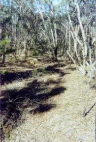 93-24c Feb 01: Pine wildings
emerging in native bush east of the plantation.
93-24c Feb 01: Pine wildings
emerging in native bush east of the plantation. |
 93-24d Feb 01: Close up
of southern boundary track.
93-24d Feb 01: Close up
of southern boundary track. |
 93-24e Feb 01: Wildings
in native bush to the east of the plantation.
93-24e Feb 01: Wildings
in native bush to the east of the plantation. |
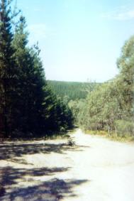 93-24f Feb 01: Plantation
boundary eastern edge.
93-24f Feb 01: Plantation
boundary eastern edge. |
HOME
|